Share on Facebook
 Share on X
 Share by Email
 Share on Google Classroom
Fort Sainte-Thérèse is a 17th and 18th century military site. The first fort was built on the banks of the Richelieu River in 1665. It served as a supply post for the Carignan-Salières regiment to fight the Haudenosaunee. It was later abandoned and then rebuilt twice before the fall of New France, after which it fell into oblivion for nearly 150 years.
Strategic Waterway
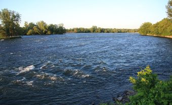
The Richelieu River was already used as a north-south communication line for the First Nations long before European colonization. It provided access to the St. Lawrence River to the north and Lake Champlain to the south, which leads to the Hudson River.
For New France, the river was both a military advantage and a weakness. A highway well ahead of its time, it was the scene of clashes during most of the conflicts of the French and British colonial periods.
First Fort in 1665
As early as 1665, New France wanted to put an end to the Haudenosaunee attacks that limited the colonization in the Montreal region and the economic development of the colony. (See Settlement of New France.) Authorities ordered the construction of a series of five fortifications along the Richelieu River: Richelieu (Sorel), Saint-Louis (Chambly), Sainte-Thérèse, Saint-Jean and Sainte-Anne (Isle La Motte).
In September 1665, Governor Alexandre de Prouville de Tracy instructed the commander of the Carignan-Salières regiment, Henri de Chastelard, Marquis de Salières, to construct a fort along the Richelieu River, a few leagues south of Fort Chambly. The rapids between Fort Chambly and the site of the future fort justified the choice of its location, as portaging was necessary to continue navigating the river.

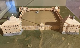
About 350 soldiers accompanied Henri de Chastelard de Salières. In early October, the troops built a double wooden palisade about fifteen feet high. The new fort was rectangular in shape and equipped with four bastions. Construction was completed on 15 October, the feast day of St. Teresa in the Catholic liturgical calendar.
During the campaigns of 1666 and 1667, Fort Sainte-Thérèse served as a staging post, a supply post and a rallying point for the troops.
After the peace treaty with the Haudenosaunee was signed in 1667, the fort was abandoned. However, in 1704, the site was used as a gathering place for the members of the expedition against the village of Deerfield, New England. Later, it was also used to hide contraband goods.
Second Fort in 1747
During the War of the Austrian Succession, the colonial authorities feared that the inhabitants of the British colonies would try to invade New France via the Richelieu River. The site of the former Fort Sainte-Thérèse seemed ideal for serving as a rallying point for troops on their way to Fort Saint-Frédéric, south of Lake Champlain. In March 1747, Paul Marin de la Malgue, lieutenant of troupes de la Marine, was entrusted with the construction of a new military structure on this site.
However, in 1748, Fort Saint-Jean was rebuilt. When a road was constructed connecting it to La Prairie, Fort Saint-Jean supplanted Fort Sainte-Thérèse, which was once again abandoned. Instead, the authorities requisitioned any usable equipment for the work on Fort Saint-Jean. The surrounding land was also used for settlers. (See Settlement of New France.)
Third Fort in 1760
During the Seven Years' War, Fort Sainte-Thérèse came back to life. It housed about twenty soldiers and served as a food and ammunition warehouse. Engineer Michel Chartier de Lotbinière was tasked with strengthening its defences in the fall of 1759.
The British army moved up the Richelieu Valley towards Montreal in the summer of 1760. On the night of June 15–16, an expedition of Robert Rogers' rangers set fire to the fort, the village, the provisions and the boats. They killed the livestock and captured French soldiers and civilians.
The commander-in-chief of the French troops, knight François-Gaston de Lévis, quickly ordered its reconstruction. His goal was to halt the enemy's advance. However, by the end of August 1760, as the British army was closing in, the French army abandoned and disabled the forts in the Richelieu Valley. Fort Sainte-Thérèse was burned for the second time in a few weeks. It was never rebuilt.
On 1 September 1760, British General William Haviland set up camp there while waiting to continue his journey to Montreal. A small garrison remained there for a few weeks.
Later, during the American Revolution, a detachment of the American rebel army occupied the site briefly from 1775 to 1776, as it moved up the Richelieu Valley to lay siege to Montreal.
Archaeological Remains
The Historic Sites and Monuments Board of Canada recognized Fort Sainte-Thérèse’s historical significance in 1923. (See National Historic Sites of Canada.) However, the exact location of the fort continued to be a subject of debate. In 2007, an aerial photo taken in 1938 confirmed the location of the last fort from 1760, half of which had been swallowed up by the Richelieu River. Parks Canada oversaw archaeological digs in 2008, 2009 and 2010. These lead to the conclusion that the forts of 1665, 1747 and 1760 were built on top of each other. Today, although vegetation has invaded the area, interpretive panels mark the location of the lost and rediscovered fort.