
Browse "Places"
-
Article
Western Manitoba Centennial Auditorium
Western Manitoba Centennial Auditorium. Multi-purpose auditorium located next to the Queen Elizabeth II Music Building of Brandon University. The facility is operated by an incorporated board of governors appointed by the municipal and provincial governments.
"https://thecanadianencyclopedia.ca/images/tce_placeholder.jpg?v=e9dca980c9bdb3aa11e832e7ea94f5d9" // resources/views/front/categories/view.blade.php
https://thecanadianencyclopedia.ca/images/tce_placeholder.jpg?v=e9dca980c9bdb3aa11e832e7ea94f5d9
-
Article
Western Ontario Conservatory of Music
Western Ontario Conservatory of Music (WOCM). Teaching and examining body operated under the auspices of the University of Western Ontario 1934-97.
"https://thecanadianencyclopedia.ca/images/tce_placeholder.jpg?v=e9dca980c9bdb3aa11e832e7ea94f5d9" // resources/views/front/categories/view.blade.php
https://thecanadianencyclopedia.ca/images/tce_placeholder.jpg?v=e9dca980c9bdb3aa11e832e7ea94f5d9
-
Article
Westlock
Westlock, Alta, incorporated as a town in 1916, population 4823 (2011c), 5008 (2006c). The Town of Westlock is located 80 km northwest of Edmonton.
"https://thecanadianencyclopedia.ca/images/tce_placeholder.jpg?v=e9dca980c9bdb3aa11e832e7ea94f5d9" // resources/views/front/categories/view.blade.php
https://thecanadianencyclopedia.ca/images/tce_placeholder.jpg?v=e9dca980c9bdb3aa11e832e7ea94f5d9
-
Article
Westmount
Westmount, Quebec, incorporated as a village in 1874, as a city in 1908, population 19,658 (2021 census), 20,312 (2016 census). Westmount is located on the western slopes of Mount Royal, hence its name.
"https://d3d0lqu00lnqvz.cloudfront.net/media/media/cf92a9ab-23d8-46fd-a222-55134cd53cb5.jpg" // resources/views/front/categories/view.blade.php
https://d3d0lqu00lnqvz.cloudfront.net/media/media/cf92a9ab-23d8-46fd-a222-55134cd53cb5.jpg
-
Article
Westport
Westport, NS, incorporated as a village in 1946, population 234 (2011c), 249 (2006c). The Village of Westport is located at the southern tip of Digby Neck, on the eastern side of Brier Island.
"https://thecanadianencyclopedia.ca/images/tce_placeholder.jpg?v=e9dca980c9bdb3aa11e832e7ea94f5d9" // resources/views/front/categories/view.blade.php
https://thecanadianencyclopedia.ca/images/tce_placeholder.jpg?v=e9dca980c9bdb3aa11e832e7ea94f5d9
-
Article
Westville
Westville, NS, incorporated as a town in 1894, population 3798 (2011c), 3805 (2006c). The Town of Westville is located near the Middle River, 8 km southwest of NEW GLASGOW.
"https://thecanadianencyclopedia.ca/images/tce_placeholder.jpg?v=e9dca980c9bdb3aa11e832e7ea94f5d9" // resources/views/front/categories/view.blade.php
https://thecanadianencyclopedia.ca/images/tce_placeholder.jpg?v=e9dca980c9bdb3aa11e832e7ea94f5d9
-
Article
Wetaskiwin
Wetaskiwin, Alta, incorporated as a city in 1906, population 12 525 (2011c), 11 689 (2006c). The City of Wetaskiwin is one of Alberta’s oldest cities. It began (1891) as Siding 16 on the Calgary-Edmonton Railway and was a point of departure for early, predominantly Scandinavian homesteaders.
"https://thecanadianencyclopedia.ca/images/tce_placeholder.jpg?v=e9dca980c9bdb3aa11e832e7ea94f5d9" // resources/views/front/categories/view.blade.php
https://thecanadianencyclopedia.ca/images/tce_placeholder.jpg?v=e9dca980c9bdb3aa11e832e7ea94f5d9
-
Article
Weyburn
In the 1950s the Weyburn oil field was discovered in the area and since then oil has played a very significant role in the city's economy. Agricultural production continues to be its dominant industry.
"https://thecanadianencyclopedia.ca/images/tce_placeholder.jpg?v=e9dca980c9bdb3aa11e832e7ea94f5d9" // resources/views/front/categories/view.blade.php
https://thecanadianencyclopedia.ca/images/tce_placeholder.jpg?v=e9dca980c9bdb3aa11e832e7ea94f5d9
-
Article
W.H. Hodgins & Co.
W.H. Hodgins & Co. Turn-of-the-century music store and publishing firm in Toronto's Yonge St Arcade. Over 100 copyright and non-copyright sheet music titles are extant, the earliest (1897-1900) published by Amey & Hodgins, and the remainder (1900-7) by W.H. Hodgins & Co.
"https://thecanadianencyclopedia.ca/images/tce_placeholder.jpg?v=e9dca980c9bdb3aa11e832e7ea94f5d9" // resources/views/front/categories/view.blade.php
https://thecanadianencyclopedia.ca/images/tce_placeholder.jpg?v=e9dca980c9bdb3aa11e832e7ea94f5d9
-
Article
Whale Cove
Whale Cove, Nunavut, incorporated as a hamlet in 1976, population 407 (2011c), 353 (2006c). The Hamlet of Whale Cove is located on the west coast of HUDSON BAY about 80 km south of RANKIN INLET.
"https://thecanadianencyclopedia.ca/images/tce_placeholder.jpg?v=e9dca980c9bdb3aa11e832e7ea94f5d9" // resources/views/front/categories/view.blade.php
https://thecanadianencyclopedia.ca/images/tce_placeholder.jpg?v=e9dca980c9bdb3aa11e832e7ea94f5d9
-
Article
Whatì
Whatì, NWT, established as community government in 2005, population 492 (2011c), 460 (2006c). The community of Whatì (earlier spelling Wha Ti) is located on Lac La Martre, 164 km northwest of Yellowknife.
"https://thecanadianencyclopedia.ca/images/tce_placeholder.jpg?v=e9dca980c9bdb3aa11e832e7ea94f5d9" // resources/views/front/categories/view.blade.php
https://thecanadianencyclopedia.ca/images/tce_placeholder.jpg?v=e9dca980c9bdb3aa11e832e7ea94f5d9
-
Article
Whistler
Whistler, British Columbia, incorporated as a resort municipality in 1975, population 11,854 (2016 census), 9,824 (2011 census). The resort municipality of Whistler is located about 120 km north of Vancouver near Garibaldi Provincial Park. Whistler is named after the hoary marmots (called “whistlers” because of their high-pitched warning call) that are common on Whistler Mountain.
"https://d3d0lqu00lnqvz.cloudfront.net/media/media/9d17a681-d98d-4376-ab50-e8e9ce579448.jpg" // resources/views/front/categories/view.blade.php
https://d3d0lqu00lnqvz.cloudfront.net/media/media/9d17a681-d98d-4376-ab50-e8e9ce579448.jpg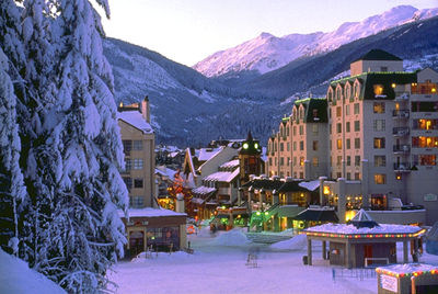
-
Article
Whitby
Whitby, Ontario, incorporated as a town in 1855, population 138,501 (2021 census), 128,377 (2016 census). The town of Whitby is located on Lake Ontario, 56 km east of Toronto.
"https://thecanadianencyclopedia.ca/images/tce_placeholder.jpg?v=e9dca980c9bdb3aa11e832e7ea94f5d9" // resources/views/front/categories/view.blade.php
https://thecanadianencyclopedia.ca/images/tce_placeholder.jpg?v=e9dca980c9bdb3aa11e832e7ea94f5d9
-
Article
Whitchurch-Stouffville
Whitchurch-Stouffville, Ontario, incorporated as a town in 1971, Regional Municipality of York, population 45,837 (2016 census), 37,628 (2011 census). The town of Whitchurch-Stouffville is located 47 km northeast of Toronto. The Jean-Baptiste Lainé Site, originally known as the Mantle Site, is located just south of Whitchurch-Stouffville. The site was the location of a large, 16th century Huron-Wendat village.
"https://thecanadianencyclopedia.ca/images/tce_placeholder.jpg?v=e9dca980c9bdb3aa11e832e7ea94f5d9" // resources/views/front/categories/view.blade.php
https://thecanadianencyclopedia.ca/images/tce_placeholder.jpg?v=e9dca980c9bdb3aa11e832e7ea94f5d9
-
Article
White Pass
White Pass, elevation 888 m, sits on the Alaska-BC boundary, approximately 125 km south of Whitehorse, YT. In 1887 the federal government sent William Ogilvie to survey the 141st meridian national boundary where it crosses the Yukon River; members of his party found the pass.
"https://thecanadianencyclopedia.ca/images/tce_placeholder.jpg?v=e9dca980c9bdb3aa11e832e7ea94f5d9" // resources/views/front/categories/view.blade.php
https://thecanadianencyclopedia.ca/images/tce_placeholder.jpg?v=e9dca980c9bdb3aa11e832e7ea94f5d9