
Browse "Places"
-
Article
Betula Lake
Betula Lake, Manitoba, is a freshwater lake and resort area in Whiteshell Provincial Park, 145 km by road northeast of Winnipeg. Opened to cottage development in the 1950s, Betula is a popular swimming, waterskiing and fishing area.
"https://thecanadianencyclopedia.ca/images/tce_placeholder.jpg?v=e9dca980c9bdb3aa11e832e7ea94f5d9" // resources/views/front/categories/view.blade.php
https://thecanadianencyclopedia.ca/images/tce_placeholder.jpg?v=e9dca980c9bdb3aa11e832e7ea94f5d9
-
Article
Biggar
Two large secondary industries process barley for malt and manufacture environmental storage tanks. A greenhouse comprising 2 ha for plant micropropagation, a salt mine and a poultry farm also provide employment. Its well-known slogan "New York is Big ... but this is Biggar" greets visitors as they enter the town.
"https://thecanadianencyclopedia.ca/images/tce_placeholder.jpg?v=e9dca980c9bdb3aa11e832e7ea94f5d9" // resources/views/front/categories/view.blade.php
https://thecanadianencyclopedia.ca/images/tce_placeholder.jpg?v=e9dca980c9bdb3aa11e832e7ea94f5d9
-
Article
Black Creek Pioneer Village
Black Creek Pioneer Village, Toronto, Ont, depicts life as it was in rural UPPER CANADA [Ontario] before 1867. The nucleus comprises 5 buildings constructed on the site by Daniel Stong, including a 3-room cabin built 1816.
"https://d3d0lqu00lnqvz.cloudfront.net/media/media/7bd60d6b-69f6-4c5a-8511-05e7168b0127.jpg" // resources/views/front/categories/view.blade.php
https://d3d0lqu00lnqvz.cloudfront.net/media/media/7bd60d6b-69f6-4c5a-8511-05e7168b0127.jpg
-
Editorial
Editorial: The Arrival of Black Loyalists in Nova Scotia
The following article is an editorial written by The Canadian Encyclopedia staff. Editorials are not usually updated. “Freedom and a Farm.” The promise was exciting to the thousands of African Americans, most seeking to escape enslavement, who fought in British regiments during the American Revolutionary War (1775–83). Following the war, they joined tens of thousands of Loyalists — American refugees who had sided with the British. Between 80,000 and 100,000 Loyalists eventually fled the United States. About half came to British North America. The main waves arrived in 1783 and 1784. The territory that now includes the Maritime provinces became home to more than 30,000 Loyalists. Most of coastal Nova Scotia received Loyalist settlers, as did Cape Breton and Prince Edward Island (then called St. John’s Island).
"https://d3d0lqu00lnqvz.cloudfront.net/media/media/be13527b-b76d-408a-afca-30acbd4f7bfc.png" // resources/views/front/categories/view.blade.php
https://d3d0lqu00lnqvz.cloudfront.net/media/media/be13527b-b76d-408a-afca-30acbd4f7bfc.png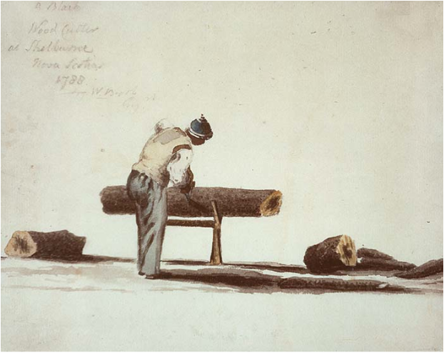
-
Article
Siksika (Blackfoot)
The Siksika, also known as the Blackfoot (or Blackfeet in the United States), are one of the three nations that make up the Blackfoot Confederacy (the other two are the Piikani and Kainai). In the Blackfoot language, Siksika means “Blackfoot.” As of February 2026, the Siksika Nation registered population was 8,056, with 4,349 living on Siksika Nation's reserve in Alberta.
"https://d3d0lqu00lnqvz.cloudfront.net/media/media/48719197-b6cd-42c6-ae22-4978290d2f26.jpg" // resources/views/front/categories/view.blade.php
https://d3d0lqu00lnqvz.cloudfront.net/media/media/48719197-b6cd-42c6-ae22-4978290d2f26.jpg
-
Article
Blainville
Blainville, Quebec, incorporated as a city in 1968, population 59,819 (2021 census), 56,863 (2016 census). Blainville is located 25 km north of Montreal on the North Shore of the St. Lawrence River.
"https://d3d0lqu00lnqvz.cloudfront.net/media/media/f10e3371-4bbb-40a2-b591-f640fdca2af3.jpg" // resources/views/front/categories/view.blade.php
https://d3d0lqu00lnqvz.cloudfront.net/media/media/f10e3371-4bbb-40a2-b591-f640fdca2af3.jpg
-
Article
Blanc-Sablon Archaeological Sites
The Blanc-Sablon area is located on Québec's eastern edge, close to the border with Labrador.
"https://d3d0lqu00lnqvz.cloudfront.net/media/media/43ea7f0d-1cb8-4765-8fe8-6a9bd647b147.jpg" // resources/views/front/categories/view.blade.php
https://d3d0lqu00lnqvz.cloudfront.net/media/media/43ea7f0d-1cb8-4765-8fe8-6a9bd647b147.jpg
-
Article
Blind River
Blind River, Ont, incorporated as a town in 1906, population 3549 (2011c), 3780 (2006c). The Town of Blind River is located at the mouth of the Mississagi River on the North Channel of Lake Huron, 132 km southeast of Sault Ste Marie.
"https://thecanadianencyclopedia.ca/images/tce_placeholder.jpg?v=e9dca980c9bdb3aa11e832e7ea94f5d9" // resources/views/front/categories/view.blade.php
https://thecanadianencyclopedia.ca/images/tce_placeholder.jpg?v=e9dca980c9bdb3aa11e832e7ea94f5d9
-
Article
Bloodvein River
Named, perhaps, for the red granite stripes running through the bedrock near its source, the Bloodvein River begins in the vast wilderness of the Canadian Shield, 600 km northwest of Thunder Bay, Ont, and 500 km northeast of Winnipeg.
"https://thecanadianencyclopedia.ca/images/tce_placeholder.jpg?v=e9dca980c9bdb3aa11e832e7ea94f5d9" // resources/views/front/categories/view.blade.php
https://thecanadianencyclopedia.ca/images/tce_placeholder.jpg?v=e9dca980c9bdb3aa11e832e7ea94f5d9
-
Article
Bloody Falls
Bloody Falls are rapids located about 15 km above the mouth of the Coppermine River in the central Arctic.
"https://d3d0lqu00lnqvz.cloudfront.net/media/media/ae69d3f2-aebe-4a53-b1a8-ddfebac57e3f.jpg" // resources/views/front/categories/view.blade.php
https://d3d0lqu00lnqvz.cloudfront.net/media/media/ae69d3f2-aebe-4a53-b1a8-ddfebac57e3f.jpg
-
Article
Blue Mountains
The Blue Mountains (Montagnes Bleues) is a 240 km long group of high hills along the Canada and United States border in the Eastern Townships.
"https://thecanadianencyclopedia.ca/images/tce_placeholder.jpg?v=e9dca980c9bdb3aa11e832e7ea94f5d9" // resources/views/front/categories/view.blade.php
https://thecanadianencyclopedia.ca/images/tce_placeholder.jpg?v=e9dca980c9bdb3aa11e832e7ea94f5d9
-
Article
Bluefish Caves
Bluefish Caves contain the oldest undisturbed archaeological evidence in Canada.
"https://d3d0lqu00lnqvz.cloudfront.net/media/media/b91c5592-6724-4e23-8a45-aa3a4ce223f0.jpg" // resources/views/front/categories/view.blade.php
https://d3d0lqu00lnqvz.cloudfront.net/media/media/b91c5592-6724-4e23-8a45-aa3a4ce223f0.jpg
-
Article
Bocabec Archaeological Site
The 1883 excavation of a portion of the Bocabec site by the Natural History Society of New Brunswick marked the beginning of systematic, scientific examinations of shell-bearing archaeological sites (see shell middens) in Canada.
"https://d3d0lqu00lnqvz.cloudfront.net/media/media/29f3aa50-f086-4d99-9f28-dbc389692cf9.jpg" // resources/views/front/categories/view.blade.php
https://d3d0lqu00lnqvz.cloudfront.net/media/media/29f3aa50-f086-4d99-9f28-dbc389692cf9.jpg
-
Article
Bois-des-Filion
Bois-des-Filion owes its name to Antoine Feuillon dit Filion, the French pioneer who settled there in 1684, and to the large maple grove located on the Filion family property.
"https://d3d0lqu00lnqvz.cloudfront.net/media/media/c3935abd-db71-4e62-bb4b-b6fa5fc7d2ed.jpg" // resources/views/front/categories/view.blade.php
https://d3d0lqu00lnqvz.cloudfront.net/media/media/c3935abd-db71-4e62-bb4b-b6fa5fc7d2ed.jpg
-
Article
Boisbriand
First set up as a municipality under the name of Sainte-Thérèse-Ouest in 1946, its name was changed in 1974. The name recalls Michel-Sidrac Dugué, Sieur de Boisbriand (1638-88), to whom was granted the seigneury des Mille-Îles in 1683.
"https://thecanadianencyclopedia.ca/images/tce_placeholder.jpg?v=e9dca980c9bdb3aa11e832e7ea94f5d9" // resources/views/front/categories/view.blade.php
https://thecanadianencyclopedia.ca/images/tce_placeholder.jpg?v=e9dca980c9bdb3aa11e832e7ea94f5d9