
Browse "Places"
-
Article
Morris
Morris, Manitoba, incorporated as a town in 1883, population 1797 (2011c), 1643 (2006c). The Town of Morris is located at the confluence of the Red and Morris rivers, 55 km south of Winnipeg.
"https://thecanadianencyclopedia.ca/images/tce_placeholder.jpg?v=e9dca980c9bdb3aa11e832e7ea94f5d9" // resources/views/front/categories/view.blade.php
https://thecanadianencyclopedia.ca/images/tce_placeholder.jpg?v=e9dca980c9bdb3aa11e832e7ea94f5d9
-
Article
Motherwell Homestead
Motherwell Homestead, near Abernethy, Saskatchewan, was the residence of William R. MOTHERWELL for over 60 years. He homesteaded in what is now Saskatchewan in 1882.
"https://thecanadianencyclopedia.ca/images/tce_placeholder.jpg?v=e9dca980c9bdb3aa11e832e7ea94f5d9" // resources/views/front/categories/view.blade.php
https://thecanadianencyclopedia.ca/images/tce_placeholder.jpg?v=e9dca980c9bdb3aa11e832e7ea94f5d9
-
Article
Music at Mount Allison University
Mount Allison Ladies' College instituted a music program at its inception. In 1874 its first certificates in music, both in piano, were awarded to Ravinia Stewart and Alma Hickman.
"https://d3d0lqu00lnqvz.cloudfront.net/media/media/5e608cc7-1a54-41d1-b9ca-9b40604eaefe.jpg" // resources/views/front/categories/view.blade.php
https://d3d0lqu00lnqvz.cloudfront.net/media/media/5e608cc7-1a54-41d1-b9ca-9b40604eaefe.jpg
-
Article
Mount Assiniboine
Mount Assiniboine, elevation 3618 m, the highest mountain between the Trans-Canada Highway and the US border in the Rocky Mts, is often called "The Matterhorn of the Canadian Rockies."
"https://thecanadianencyclopedia.ca/images/tce_placeholder.jpg?v=e9dca980c9bdb3aa11e832e7ea94f5d9" // resources/views/front/categories/view.blade.php
https://thecanadianencyclopedia.ca/images/tce_placeholder.jpg?v=e9dca980c9bdb3aa11e832e7ea94f5d9
-
Article
Mount Assiniboine Provincial Park
Mount Assiniboine Provincial Park (est 1922, 386 km 2 ) is an area of mountain peaks, alpine meadows and lakes dominated by Mount ASSINIBOINE (about 35 km south of BANFF , Alberta). The park, which is mainly above 1500 m,
"https://thecanadianencyclopedia.ca/images/tce_placeholder.jpg?v=e9dca980c9bdb3aa11e832e7ea94f5d9" // resources/views/front/categories/view.blade.php
https://thecanadianencyclopedia.ca/images/tce_placeholder.jpg?v=e9dca980c9bdb3aa11e832e7ea94f5d9
-
Article
Mount Carleton Provincial Park
New Brunswick's largest PROVINCIAL PARK, Mount Carleton Provincial Park (established 1970, 174.27 km2), features forests and abundant wildlife.
"https://thecanadianencyclopedia.ca/images/tce_placeholder.jpg?v=e9dca980c9bdb3aa11e832e7ea94f5d9" // resources/views/front/categories/view.blade.php
https://thecanadianencyclopedia.ca/images/tce_placeholder.jpg?v=e9dca980c9bdb3aa11e832e7ea94f5d9
-
Article
Mount Edith Cavell
Mount Edith Cavell, elevation 3368 m, the highest mountain in the environs of Jasper, Alberta, is situated west of the Athabasca River, 24 km south of Jasper.
"https://thecanadianencyclopedia.ca/images/tce_placeholder.jpg?v=e9dca980c9bdb3aa11e832e7ea94f5d9" // resources/views/front/categories/view.blade.php
https://thecanadianencyclopedia.ca/images/tce_placeholder.jpg?v=e9dca980c9bdb3aa11e832e7ea94f5d9
-
Article
Mount Edziza Provincial Park
Mount Edziza Provincial Park (est 1972, 2300 km 2 ha) comprises part of the Tahltan Highlands, between the Stikine and Iskut rivers in BC. The nearest community is Telegraph Creek, 20 km northwest of the park.
"https://thecanadianencyclopedia.ca/images/tce_placeholder.jpg?v=e9dca980c9bdb3aa11e832e7ea94f5d9" // resources/views/front/categories/view.blade.php
https://thecanadianencyclopedia.ca/images/tce_placeholder.jpg?v=e9dca980c9bdb3aa11e832e7ea94f5d9
-
Article
Mount Logan
Mount Logan, with an elevation of 5,959 m, is Canada's highest mountain. It is also the second tallest peak in North America after the United States’ Mount Denali. Mount Logan is located within Yukon’s Kluane National Park and Reserve as well as within the traditional territories of the Kluane and White River First Nations (see First Nations in Yukon).
"https://d3d0lqu00lnqvz.cloudfront.net/mountlogan/mount-logan.jpg" // resources/views/front/categories/view.blade.php
https://d3d0lqu00lnqvz.cloudfront.net/mountlogan/mount-logan.jpg
-
Article
Mount Lucania
Lucania, Mount, elevation 5226 m, the third-highest mountain in Canada, is located 29 km east of the Alaska border and 50 km north of Mt LOGAN in the Yukon's St Elias Range. It was named by the duke of Abruzzi, who viewed it from Mount St Elias in 1897.
"https://thecanadianencyclopedia.ca/images/tce_placeholder.jpg?v=e9dca980c9bdb3aa11e832e7ea94f5d9" // resources/views/front/categories/view.blade.php
https://thecanadianencyclopedia.ca/images/tce_placeholder.jpg?v=e9dca980c9bdb3aa11e832e7ea94f5d9
-
Article
Mount Pearl
Mount Pearl, NL, incorporated as a city in 1988, population 24 284 (2011c), 24 671 (2006c). The City of Mount Pearl, the province's second-largest city, is situated just southwest of St John's.
"https://thecanadianencyclopedia.ca/images/tce_placeholder.jpg?v=e9dca980c9bdb3aa11e832e7ea94f5d9" // resources/views/front/categories/view.blade.php
https://thecanadianencyclopedia.ca/images/tce_placeholder.jpg?v=e9dca980c9bdb3aa11e832e7ea94f5d9
-
Article
Mount Revelstoke National Park
Mount Revelstoke National Park (est 1914, 259.7 km2) is a place of contrasting landscape, varying from rain forests and lush alpine meadows to barren, rocky ridges and glaciers. The jagged spires of the Selkirk Mountains are the backdrop for this park. Grizzly bear and caribou range throughout, while mountain goats frequent the rocky bluffs. Due to the small size of the park, and extensive clear-cut logging in adjacent lands, the park lacks ecological integrity, and its populations of large mammals, particularly caribou, are threatened. Alpine meadows feature pika, hoary marmot and golden-mantled ground squirrel, often under the gaze of the golden eagle. Between October and June the park is covered in a thick blanket of snow, but in the brief summer, meadows glow with the blossoms of lupine, aster and Indian paintbrush. The Meadows in the Sky Parkway provides road access to lush alpine meadows.
"https://d3d0lqu00lnqvz.cloudfront.net/media/media/d2b11ccd-0a14-4857-aafd-b31bb02c12ec.jpg" // resources/views/front/categories/view.blade.php
https://d3d0lqu00lnqvz.cloudfront.net/media/media/d2b11ccd-0a14-4857-aafd-b31bb02c12ec.jpg
-
Article
Mount Robson
Mount Robson, with a maximum elevation of 3,954 m, making it the highest mountain in the Canadian Rockies, is located 72 km northwest of Jasper townsite and 10 km southwest of the Continental Divide.
"https://d3d0lqu00lnqvz.cloudfront.net/mountrobson/mount-robson.jpg" // resources/views/front/categories/view.blade.php
https://d3d0lqu00lnqvz.cloudfront.net/mountrobson/mount-robson.jpg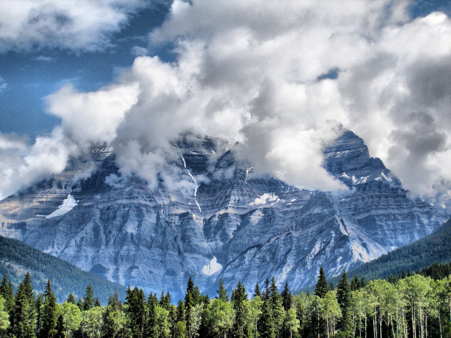
-
Article
Mount Royal
Mount Royal is a short mountain with a wide base covering ten square kilometres. It is close to the geographic centre of the Island of Montreal. Mount Royal is Montreal’s defining physical feature and a protected site; it was designated a Historic and Natural District by the government of Quebec in 2005. By law, new buildings in Montreal may not be taller than Mount Royal. The mountain occupies a central position, not only in the urban landscape of the city of Montreal, but also in its history, culture and society.
"https://d3d0lqu00lnqvz.cloudfront.net/media/media/Mount-Royal.jpg" // resources/views/front/categories/view.blade.php
https://d3d0lqu00lnqvz.cloudfront.net/media/media/Mount-Royal.jpg
-
Article
Mount Royal (town)
The Town of Mount Royal (Ville de Mont-Royal in French, also known by its English-language initials TMR), Quebec, founded 1912, population 20,953 (2021 census), 20,276 (2016 census). The Town of Mount-Royal is a planned community located on the island of Montreal, located northwest of the small mountain for which it is named (Mount Royal). It is an affluent and independent suburb entirely encircled by the city of Montreal. It is an excellent example of the garden city model city concept popular in the early 20th century. The community was created to finance the construction of the Mount Royal Tunnel, a railway tunnel that allowed the Canadian Northern Railway to access downtown Montreal.
"https://d3d0lqu00lnqvz.cloudfront.net/Parc_Connaught_Park.jpg" // resources/views/front/categories/view.blade.php
https://d3d0lqu00lnqvz.cloudfront.net/Parc_Connaught_Park.jpg