
Browse "Places"
-
Article
Ksan
Ksan (or ‘Ksan) is a historical village, museum and campground, owned and operated by the Gitanmaax Band. It is located at the junction of the Skeena and Bulkley rivers in Hazelton, British Columbia. Ksan was established in 1970 as way to promote and preserve Gitxsan culture and history.
"https://d3d0lqu00lnqvz.cloudfront.net/media/media/2fd73ae3-5ed7-4894-b6ae-caa2ac25e639.jpg" // resources/views/front/categories/view.blade.php
https://d3d0lqu00lnqvz.cloudfront.net/media/media/2fd73ae3-5ed7-4894-b6ae-caa2ac25e639.jpg
-
Article
Kugaaruk
Kugaaruk, Nunavut, incorporated as a hamlet in 1972, population 771 (2011c), 688 (2006c). The Hamlet of Kugaaruk is located in the northeastern Arctic on the coast within Pelly Bay
"https://thecanadianencyclopedia.ca/images/tce_placeholder.jpg?v=e9dca980c9bdb3aa11e832e7ea94f5d9" // resources/views/front/categories/view.blade.php
https://thecanadianencyclopedia.ca/images/tce_placeholder.jpg?v=e9dca980c9bdb3aa11e832e7ea94f5d9
-
Article
Kugluktuk
Kugluktuk, Nunavut, incorporated as a hamlet in 1981, population 1,382 (2021 census), population 1,491 (2016 census). The Hamlet of Kugluktuk, formerly known as Coppermine, is situated west of the mouth of the Coppermine River on the mainland Arctic coast. The hamlet changed its name in 1996 to Kugluktuk, which means "place of rapids," referring to the rapids at Bloody Falls, 15 km upstream.
"https://d3d0lqu00lnqvz.cloudfront.net/kugluktuk/Kugluktuk-2006.jpg" // resources/views/front/categories/view.blade.php
https://d3d0lqu00lnqvz.cloudfront.net/kugluktuk/Kugluktuk-2006.jpg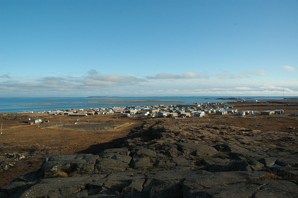
-
Article
La Baie
La Baie was founded in 1838 by employees of the Société des Vingt-et-un, a Charlevoix forestry company bought by William Price in 1842. Price's sawmills were soon joined by port facilities, making La Baie, a natural harbour, a major port on the Atlantic coast.
"https://thecanadianencyclopedia.ca/images/tce_placeholder.jpg?v=e9dca980c9bdb3aa11e832e7ea94f5d9" // resources/views/front/categories/view.blade.php
https://thecanadianencyclopedia.ca/images/tce_placeholder.jpg?v=e9dca980c9bdb3aa11e832e7ea94f5d9
-
Article
La Grande Rivière
La Grande Rivière, 893 km long, rises in the rugged forest highlands of central Québec and drains west into James Bay.
"https://d3d0lqu00lnqvz.cloudfront.net/media/media/33649494-8426-4ec2-8001-9f2613ea3d08.jpg" // resources/views/front/categories/view.blade.php
https://d3d0lqu00lnqvz.cloudfront.net/media/media/33649494-8426-4ec2-8001-9f2613ea3d08.jpg
-
Article
Grosse Île and the Irish Memorial National Historic Site
Grosse Île is an island in the St. Lawrence Estuary, 46 km downstream from Quebec City. It is 2.9 km long and 1 km wide and consists of a wooded Appalachian ridge surrounded by a coastline of coves and capes. It is one of the 21 islands composing the Isle-aux-Grues archipelago. It has also been known as Île de Grâce and Quarantine Island. From 1832 to 1937, it was used as a quarantine station for the port of Quebec City. Over this century of activity, more than 4 million immigrants passed through this station, including nearly 90,000 during the “black year” of 1847. Closely tied to memories of Irish immigration to Canada, Grosse Île is a Canadian national historic site, administered by Parks Canada and open to the public.
"https://d3d0lqu00lnqvz.cloudfront.net/media/media/44499914-6865-46c3-8511-b96092327f81.jpg" // resources/views/front/categories/view.blade.php
https://d3d0lqu00lnqvz.cloudfront.net/media/media/44499914-6865-46c3-8511-b96092327f81.jpg
-
Article
La Loche
The NORTH WEST COMPANY had a post at the Portage as early as 1808 and the HUDSON'S BAY COMPANY soon followed suit. Here the Athabasca and Mackenzie River brigades exchanged goods and furs with the La Loche brigade.
"https://thecanadianencyclopedia.ca/images/tce_placeholder.jpg?v=e9dca980c9bdb3aa11e832e7ea94f5d9" // resources/views/front/categories/view.blade.php
https://thecanadianencyclopedia.ca/images/tce_placeholder.jpg?v=e9dca980c9bdb3aa11e832e7ea94f5d9
-
Article
La Maison des Canadiens
“Within sight of this house over 100 men of the Queen’s Own Rifles were killed or wounded, in the first few minutes of the landings.”
"https://d3d0lqu00lnqvz.cloudfront.net/media/media/3a69be0a-4b74-40aa-a2d9-cfe6007d77a2.jpg" // resources/views/front/categories/view.blade.php
https://d3d0lqu00lnqvz.cloudfront.net/media/media/3a69be0a-4b74-40aa-a2d9-cfe6007d77a2.jpg
-
Article
La Malbaie
La Malbaie, Quebec, incorporated as a town in 1999, pop 8,235 (2021 census), 8,271 (2016 census). La Malbaie is situated on the lower north shore of the St. Lawrence River at the mouth of Rivière Malbaie, 150 km east of Quebec City. The town is the result of two mergers. The first occurred in 1995 and involved La Malbaie (incorporated as a town in 1958) and Pointe-au-Pic (village, 1876). Four years later, Rivière-Malbaie (town, 1938), Saint-Fidèle (town, 1997), Cap-à-l'Aigle (village, 1916) and Sainte-Agnès (parish municipality, 1855) were included.
"https://d3d0lqu00lnqvz.cloudfront.net/media/media/e8e68977-8038-4c47-8ee4-2970a6e433c3.jpg" // resources/views/front/categories/view.blade.php
https://d3d0lqu00lnqvz.cloudfront.net/media/media/e8e68977-8038-4c47-8ee4-2970a6e433c3.jpg
-
Article
La Mauricie National Park
La Mauricie National Park (est 1977, 536.1 km2), first set aside in 1970, is situated about 220 km northeast of Montréal. The gently rolling Laurentian Highlands form a backdrop for the park's billion-year-old Precambrian granite and gneiss landscape, sculpted by the action of glaciers during the last Ice Age. The same glaciers scraped out the numerous lakes dotting the park.
"https://d3d0lqu00lnqvz.cloudfront.net/media/media/3996aa5e-19b5-4483-b7b5-84ce22f09502.jpg" // resources/views/front/categories/view.blade.php
https://d3d0lqu00lnqvz.cloudfront.net/media/media/3996aa5e-19b5-4483-b7b5-84ce22f09502.jpg
-
Article
Montreal's Little Italy
The product of two major Italian immigration cohorts to Canada (one from 1880 until the First World War, and the other from 1950 to 1970), Montreal’s Italian Canadian community has been gathering in the Madonna della Difesa (Notre-Dame-de-la-Défense) parish since 1910. This neighbourhood, nestled within the Rosemont-La Petite-Patrie borough, is located along Saint-Laurent Boulevard, with Saint-Zotique and Jean-Talon streets marking its limits. Always at the heart of Italian-Canadian community and cultural life in Montreal, Little Italy (Piccola Italia) is known for its buildings’ remarkable architecture and decor. It is also home to a true institution of Montreal’s cityscape: the Jean‑Talon Market.
"https://d3d0lqu00lnqvz.cloudfront.net/media/media/b11aa219-9b12-4d95-a4b5-29522e0bbbf8.JPG" // resources/views/front/categories/view.blade.php
https://d3d0lqu00lnqvz.cloudfront.net/media/media/b11aa219-9b12-4d95-a4b5-29522e0bbbf8.JPG
-
Article
La Pocatière
In 1672, François Pollet de La Combe-Pocatière received the seigneurie de la Grande-Anse as a gift from his father-in-law, Nicholas Juchereau de Saint-Denys. This territory became the parish of Ste-Anne-de-La-Pocatière, and later, the city of La Pocatière.
"https://d3d0lqu00lnqvz.cloudfront.net/media/media/b102f2b5-4d17-48f9-a9d0-64c5fb825bac.jpg" // resources/views/front/categories/view.blade.php
https://d3d0lqu00lnqvz.cloudfront.net/media/media/b102f2b5-4d17-48f9-a9d0-64c5fb825bac.jpg
-
Article
La Prairie
La Prairie, Quebec, incorporated as a town in 1909, population 26,406 (2021 census), 24,110 (2016 census). A suburb of Montreal, La Prairie is located in the South Shore of the St. Lawrence River.
"https://d3d0lqu00lnqvz.cloudfront.net/media/media/thumbnails/e19b5124-6937-4ec1-bb31-a56594daed20.jpg" // resources/views/front/categories/view.blade.php
https://d3d0lqu00lnqvz.cloudfront.net/media/media/thumbnails/e19b5124-6937-4ec1-bb31-a56594daed20.jpg
-
Article
La Ronge
Occupation of the present townsite started when Archdeacon John Alexander Mackay established a residential school and sawmill (1898). Not accessible by road until 1947, the largely Indigenous community grew very slowly for many years.
"https://thecanadianencyclopedia.ca/images/tce_placeholder.jpg?v=e9dca980c9bdb3aa11e832e7ea94f5d9" // resources/views/front/categories/view.blade.php
https://thecanadianencyclopedia.ca/images/tce_placeholder.jpg?v=e9dca980c9bdb3aa11e832e7ea94f5d9
-
Article
La Sarre
HistoryFounded in 1917, it was one of the first agricultural centres to be settled when the transcontinental railway opened up the Abitibi region around 1910.
"https://thecanadianencyclopedia.ca/images/tce_placeholder.jpg?v=e9dca980c9bdb3aa11e832e7ea94f5d9" // resources/views/front/categories/view.blade.php
https://thecanadianencyclopedia.ca/images/tce_placeholder.jpg?v=e9dca980c9bdb3aa11e832e7ea94f5d9