
Browse "Places"
-
Article
Fredericton
Fredericton, NB, incorporated as a city in 1848, population 58,220 (2016 c), 56,224 (2011 c). The city of Fredericton is the provincial capital and is located in central New Brunswick, just below the head of tide on the Saint John River, 135 km inland from the Bay of Fundy.
"https://d3d0lqu00lnqvz.cloudfront.net/media/media/61e2af78-c031-49ab-b8d2-9e86e8377475.jpg" // resources/views/front/categories/view.blade.php
https://d3d0lqu00lnqvz.cloudfront.net/media/media/61e2af78-c031-49ab-b8d2-9e86e8377475.jpg
-
Article
Music in Fredericton
Fredericton, NB. New Brunswick's capital city, located on the Saint John River on the site of a 1732 Acadian, and later Loyalist English, settlement at St Anne's Point. The name Fredericton was adopted in 1785. Incorporation as a city was accomplished in 1848.
"https://thecanadianencyclopedia.ca/images/tce_placeholder.jpg?v=e9dca980c9bdb3aa11e832e7ea94f5d9" // resources/views/front/categories/view.blade.php
https://thecanadianencyclopedia.ca/images/tce_placeholder.jpg?v=e9dca980c9bdb3aa11e832e7ea94f5d9
-
Article
French River
The French River, 290 km long (to head of Sturgeon River), rises from Lake Nipissing in northeastern Ontario and flows 110 km west towards Georgian Bay.
"https://thecanadianencyclopedia.ca/images/tce_placeholder.jpg?v=e9dca980c9bdb3aa11e832e7ea94f5d9" // resources/views/front/categories/view.blade.php
https://thecanadianencyclopedia.ca/images/tce_placeholder.jpg?v=e9dca980c9bdb3aa11e832e7ea94f5d9
-
Article
French Shore
The French Shore was an area of coastal Newfoundland where French fishermen enjoyed treaty rights granted by the British from 1713 to 1904.
"https://thecanadianencyclopedia.ca/images/tce_placeholder.jpg?v=e9dca980c9bdb3aa11e832e7ea94f5d9" // resources/views/front/categories/view.blade.php
https://thecanadianencyclopedia.ca/images/tce_placeholder.jpg?v=e9dca980c9bdb3aa11e832e7ea94f5d9
-
Article
Frobisher Bay
Iqaluit is near a traditional South Baffin Inuit fishing camp, where a summer camp was established each year to fish (photo by Barbara Brundege and Eugene Fisher).\r\n Frobisher Bay is a deep indentation in the extreme southeast coastline of BAFFIN ISLAND, over 230 km long and 40 km wide at the mouth, narrowing to 20 km towards its head. The configuration of the bay has a funnelling effect, so that the harbour of the city...
"https://d3d0lqu00lnqvz.cloudfront.net/media/media/66fc9616-fe99-4ef4-a49a-d7528ad2566e.jpg" // resources/views/front/categories/view.blade.php
https://d3d0lqu00lnqvz.cloudfront.net/media/media/66fc9616-fe99-4ef4-a49a-d7528ad2566e.jpg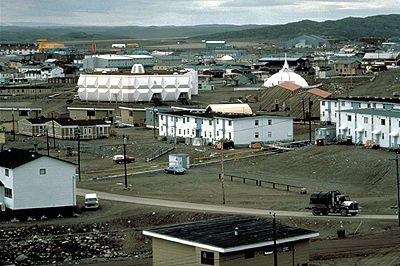
-
Article
Fruitvale
Fruitvale, BC, incorporated as a village in 1952, population 2016 (2011c), 1952 (2006c). The Village of Fruitvale is located in the southern interior of BC close to the US border, 11 km east of TRAIL, 645 km east of Vancouver.
"https://d3d0lqu00lnqvz.cloudfront.net/media/media/0f6874e9-2706-4ff6-a872-f66d45e622f8.jpg" // resources/views/front/categories/view.blade.php
https://d3d0lqu00lnqvz.cloudfront.net/media/media/0f6874e9-2706-4ff6-a872-f66d45e622f8.jpg
-
Article
Fundy National Park
Fundy National Park (established 1948, 205.9 km2), renowned for its high tides averaging 9 m, stretches for 13 km along the Bay of Fundy and extends inland where wooded hills are cut by deep valleys and tumbling streams.
"https://d3d0lqu00lnqvz.cloudfront.net/media/media/4bc5b21a-e673-4f22-9e76-db46b45d42b6.jpg" // resources/views/front/categories/view.blade.php
https://d3d0lqu00lnqvz.cloudfront.net/media/media/4bc5b21a-e673-4f22-9e76-db46b45d42b6.jpg
-
Article
Funk Island
Funk Island, 25 ha, is a flat, 15 m high, wedge-shaped granite island 800 m by 400 m lying 60 km off Newfoundland's northeast coast, east of FOGO ISLAND. The origin of the name is unknown, though it may have been inspired by the smell of the guano that covers much of the island.
"https://thecanadianencyclopedia.ca/images/tce_placeholder.jpg?v=e9dca980c9bdb3aa11e832e7ea94f5d9" // resources/views/front/categories/view.blade.php
https://thecanadianencyclopedia.ca/images/tce_placeholder.jpg?v=e9dca980c9bdb3aa11e832e7ea94f5d9
-
Article
Fur Trade Route Networks
Throughout the period of the historical fur trade (early 17th to the mid-19th century), water routes were the natural “highways” of First Nations trappers and European fur traders. Water trading networks connected Indigenous societies from the Atlantic Ocean, along the St. Lawrence River to the Great Lakes, and then on towards the Hudson Bay watershed. North America’s waterborne geography facilitated intracontinental travel, enabled European expansion and settlement into Indigenous North America, and shaped the contours of Euro-Indigenous relations in the context of the fur trade. These extensive and interconnected systems of rivers, lakes and overland trails criss-crossed Indigenous territories and had been used for generations. At the height of the fur trade, the principal canoe route extended westward from the Island of Montreal through the Great Lakes, and from the northwestern shore of Lake Superior over the height of land into the Hudson Bay watershed. From the Lake Winnipeg basin, Indigenous trappers and European traders fanned out towards the Western Prairies via the Assiniboine, Qu’Appelle and Souris rivers, towards the foothills of the Rocky Mountains via the North and South branches of the Saskatchewan River, and finally towards the Athabasca Country via the Sturgeon-weir River and the Methye Portage.
"https://d3d0lqu00lnqvz.cloudfront.net/media/media/6a52818a-3f78-427a-a201-5e6bc9c5d874.jpg" // resources/views/front/categories/view.blade.php
https://d3d0lqu00lnqvz.cloudfront.net/media/media/6a52818a-3f78-427a-a201-5e6bc9c5d874.jpg
-
Article
Fury and Hecla Strait
Fury and Hecla Strait is located at the northern end of Foxe Basin, connecting the basin with the Gulf of Boothia, and separating Melville Peninsula on the mainland and Baffin Island to the north.
"https://d3d0lqu00lnqvz.cloudfront.net/media/media/4aad02e3-72bd-400c-87ab-d1380ccad4dc.jpg" // resources/views/front/categories/view.blade.php
https://d3d0lqu00lnqvz.cloudfront.net/media/media/4aad02e3-72bd-400c-87ab-d1380ccad4dc.jpg
-
Article
Gagetown
Gagetown, NB, incorporated as a village in 1966, population 698 (2011c), 719 (2006c). The Village of Gagetown is situated on Gagetown Creek, adjacent to the SAINT JOHN RIVER and opposite the mouth of the Jemseg River.
"https://thecanadianencyclopedia.ca/images/tce_placeholder.jpg?v=e9dca980c9bdb3aa11e832e7ea94f5d9" // resources/views/front/categories/view.blade.php
https://thecanadianencyclopedia.ca/images/tce_placeholder.jpg?v=e9dca980c9bdb3aa11e832e7ea94f5d9
-
Article
Galiano Island
Galiano Island, 5787 ha, is one of BC's GULF ISLANDS, named for Spanish navy commander Dionisio Alcalá-Galiano, who explored the area in 1792. It has the driest climate of the islands.
"https://thecanadianencyclopedia.ca/images/tce_placeholder.jpg?v=e9dca980c9bdb3aa11e832e7ea94f5d9" // resources/views/front/categories/view.blade.php
https://thecanadianencyclopedia.ca/images/tce_placeholder.jpg?v=e9dca980c9bdb3aa11e832e7ea94f5d9
-
"https://d3d0lqu00lnqvz.cloudfront.net/1200px-Old_Post_Office_Galt_Cambridge_Ontario.jpg" // resources/views/front/categories/view.blade.php
https://d3d0lqu00lnqvz.cloudfront.net/1200px-Old_Post_Office_Galt_Cambridge_Ontario.jpg
-
Article
Gambo
Gambo, NL, incorporated as a town in 1964, population 1984 (2011c), 2072 (2006c). The Town of Gambo is an amalgamation of three communities - Dark Cove, Middle Brook and Gambo - stretching along the shore at the end of Freshwater Bay, a long indraft of BONAVISTA BAY.
"https://thecanadianencyclopedia.ca/images/tce_placeholder.jpg?v=e9dca980c9bdb3aa11e832e7ea94f5d9" // resources/views/front/categories/view.blade.php
https://thecanadianencyclopedia.ca/images/tce_placeholder.jpg?v=e9dca980c9bdb3aa11e832e7ea94f5d9
-
Article
Gananoque
Gananoque, Ont, incorporated as a town in 1890, population 5194 (2011c), 5285 (2006c). The Town of Gananoque is located at the confluence of the St Lawrence and Gananoque rivers, 29 km east of Kingston.
"https://thecanadianencyclopedia.ca/images/tce_placeholder.jpg?v=e9dca980c9bdb3aa11e832e7ea94f5d9" // resources/views/front/categories/view.blade.php
https://thecanadianencyclopedia.ca/images/tce_placeholder.jpg?v=e9dca980c9bdb3aa11e832e7ea94f5d9