Browse "Places"
-
Article
Sackville
Sackville, NB, incorporated as a town in 1903, population 5558 (2011c), 5411 (2006c). Sackville is situated 50 km southeast of Moncton on the Tantramar River, near the Nova Scotia border.
"https://d3d0lqu00lnqvz.cloudfront.net/media/media/5dbfbca9-4ef2-40d8-b045-723f078917dd.jpg" // resources/views/front/categories/view.blade.php
https://d3d0lqu00lnqvz.cloudfront.net/media/media/5dbfbca9-4ef2-40d8-b045-723f078917dd.jpg
-
Article
Saddle Lake Cree Nation
The Saddle Lake Cree Nation (onihcikiskwapiwinihk in Cree) is located in central Alberta approximately 180 km northeast of Edmonton. Saddle Lake Cree Nation is signatory to Treaty 6, which was signed at Fort Pitt, Saskatchewan, on 9 September 1876. Saddle Lake is a forced amalgamation of four nations: Onchimanhos/Chief Little Hunter, Seenum Band/Chief John Seenum, Blue Quill Band/Chief Blue Quill and Wasatnow Band/Chief Bear Ears. The traditional language of the Saddle Lake peoples is Plains...
"https://thecanadianencyclopedia.ca/images/tce_placeholder.jpg?v=e9dca980c9bdb3aa11e832e7ea94f5d9" // resources/views/front/categories/view.blade.php
https://thecanadianencyclopedia.ca/images/tce_placeholder.jpg?v=e9dca980c9bdb3aa11e832e7ea94f5d9
-
Article
Sagkeeng First Nation (Fort Alexander)
The people of Sagkeeng have resided at or near the Fort Alexander 3 Indian Reserve along the Winnipeg River and Traverse Bay for centuries. Treaty 1 was signed in 1871 by ancestors of the people of Sagkeeng. The reserve is located on both north and south shores at the mouth of the Winnipeg River. Derived from the Ojibwe term Zaagiing, the name Sagkeeng means “mouth of the river.” As of February 2026, the registered population...
"https://thecanadianencyclopedia.ca/images/tce_placeholder.jpg?v=e9dca980c9bdb3aa11e832e7ea94f5d9" // resources/views/front/categories/view.blade.php
https://thecanadianencyclopedia.ca/images/tce_placeholder.jpg?v=e9dca980c9bdb3aa11e832e7ea94f5d9
-
Article
Saguenay River
The Saguenay River, approximately 170 km long, issues from Lac Saint-Jean in the Laurentian Highlands of Quebec. It has a drainage basin of 88,000 km2 and a mean discharge of 1,750 m3/s. It discharges from the lake through two channels, which join some 10 km from the lake near Alma.
"https://d3d0lqu00lnqvz.cloudfront.net/media/media/a2c21ed3-15d9-49da-a892-5c898eeba2d4.jpg" // resources/views/front/categories/view.blade.php
https://d3d0lqu00lnqvz.cloudfront.net/media/media/a2c21ed3-15d9-49da-a892-5c898eeba2d4.jpg
-
Article
Saguenay-St Lawrence Marine Park
At the confluence of Fjord du Saguenay and the St Lawrence River estuary is Saguenay-St Lawrence Marine Park (established in 1998, 1138 km2). In 1990, the federal and Québec governments agreed to establish the marine park, which is to be co-managed by the federal and provincial governments. The park consists of most of the Fjord du Saguenay riverbed and the northern half of the St. Lawrence Estuary. Parc du Saguenay runs parallel to the park on either side of the fjord.
"https://d3d0lqu00lnqvz.cloudfront.net/media/media/d0d93bdb-a7a6-4b76-a22b-57d9f2138218.jpg" // resources/views/front/categories/view.blade.php
https://d3d0lqu00lnqvz.cloudfront.net/media/media/d0d93bdb-a7a6-4b76-a22b-57d9f2138218.jpg
-
Article
Saint Andrews (NB)
Saint Andrews, NB, incorporated as a town in 1903, population 1889 (2011c), 1798 (2006c). The Town of Saint Andrews is located at the mouth of the ST CROIX RIVER in the southwest corner of New Brunswick.
"https://thecanadianencyclopedia.ca/images/tce_placeholder.jpg?v=e9dca980c9bdb3aa11e832e7ea94f5d9" // resources/views/front/categories/view.blade.php
https://thecanadianencyclopedia.ca/images/tce_placeholder.jpg?v=e9dca980c9bdb3aa11e832e7ea94f5d9
-
Article
Saint-Augustin-de-Desmaures
The area was first settled in 1658, more than 20 years before the creation of the parish of Saint-Augustin-de-Desmaures. The name Saint-Augustin was supposedly given to the parish in honour of the governor of New France from 1663-1665, Augustin de Saffray de MÉZY.
"https://thecanadianencyclopedia.ca/images/tce_placeholder.jpg?v=e9dca980c9bdb3aa11e832e7ea94f5d9" // resources/views/front/categories/view.blade.php
https://thecanadianencyclopedia.ca/images/tce_placeholder.jpg?v=e9dca980c9bdb3aa11e832e7ea94f5d9
-
Article
Saint-Basile-le-Grand
Saint-Basile-le-Grand, Qué, Town, pop 15 605 (2006c), 12 385 (2001c), inc 1969. Saint-Basile-le-Grand is located between Mont Saint-Bruno and the Rivière RICHELIEU about 35 km east of MONTRÉAL.
"https://thecanadianencyclopedia.ca/images/tce_placeholder.jpg?v=e9dca980c9bdb3aa11e832e7ea94f5d9" // resources/views/front/categories/view.blade.php
https://thecanadianencyclopedia.ca/images/tce_placeholder.jpg?v=e9dca980c9bdb3aa11e832e7ea94f5d9
-
Article
Saint-Benoît-du-Lac
The community was founded by Dom Paul Vannier in 1912 when he acquired a farm at Point Gibraltar, a peninsula sloping down towards the lake. He and 3 other monks began farming and providing religious services.
"https://d3d0lqu00lnqvz.cloudfront.net/media/media/31ddf4eb-2a59-4969-932c-cea873fe5f25.jpg" // resources/views/front/categories/view.blade.php
https://d3d0lqu00lnqvz.cloudfront.net/media/media/31ddf4eb-2a59-4969-932c-cea873fe5f25.jpg
-
Article
Saint-Bruno-de-Montarville
Saint-Bruno-de-Montarville, Quebec, incorporated as a city in 1958, population 26,273 (2021 census), 26,197 (2016 census). From 2002 to 2006, it was a borough of the new city of Longueuil, which was created from the amalgamation of eight distinct municipalities, including Saint-Bruno-de-Montarville. It is a picturesque suburb located about 30 km east of downtown Montreal. It is nestled on the slopes of Mont Saint-Bruno, one of the Montérégiennes hills. Most of this beautiful mountain is the site of a provincial park. In winter, it is home to the largest and most productive downhill ski school in Quebec.
"https://thecanadianencyclopedia.ca/images/tce_placeholder.jpg?v=e9dca980c9bdb3aa11e832e7ea94f5d9" // resources/views/front/categories/view.blade.php
https://thecanadianencyclopedia.ca/images/tce_placeholder.jpg?v=e9dca980c9bdb3aa11e832e7ea94f5d9
-
Article
Saint-Charles-Borromée
Saint-Charles-Borromée, Quebec, incorporated as a municipality in 1845, population 15,285 (2021 census), 13,791 (2016 census). Saint-Charles-Borromée lies on the west bank of Rivière L'Assomption, adjacent to the city of Joliette. It is about 70 km north of Montreal.
"https://d3d0lqu00lnqvz.cloudfront.net/media/media/658ad4b0-7b40-456f-a582-61e2305fc015.jpg" // resources/views/front/categories/view.blade.php
https://d3d0lqu00lnqvz.cloudfront.net/media/media/658ad4b0-7b40-456f-a582-61e2305fc015.jpg
-
Article
Saint-Charles
Saint-Charles, Quebec, municipality incorporated in 1924, population 1,357 (2021 census), 1,482 (2016 census). Saint-Charles is located on the Richelieu River, 25 km northwest of Saint-Hyacinthe.
"https://thecanadianencyclopedia.ca/images/tce_placeholder.jpg?v=e9dca980c9bdb3aa11e832e7ea94f5d9" // resources/views/front/categories/view.blade.php
https://thecanadianencyclopedia.ca/images/tce_placeholder.jpg?v=e9dca980c9bdb3aa11e832e7ea94f5d9
-
Article
Saint-Constant
Saint-Constant, Quebec, incorporated as a city in 1973, population 29,954 (2021 census), 27,359 (2016 census). Saint-Constant is located some 30 km south of Montreal, on the South Shore of the St. Lawrence River.
"https://thecanadianencyclopedia.ca/images/tce_placeholder.jpg?v=e9dca980c9bdb3aa11e832e7ea94f5d9" // resources/views/front/categories/view.blade.php
https://thecanadianencyclopedia.ca/images/tce_placeholder.jpg?v=e9dca980c9bdb3aa11e832e7ea94f5d9
-
Article
Saint-Denis
Saint-Denis, Quebec, incorporated in 1903, population 1,048 (2021 census), 985 (2016 census). Saint-Denis-sur-Richelieu is located on the Richelieu River, 30 km northwest of Saint-Hyacinthe.
"https://thecanadianencyclopedia.ca/images/tce_placeholder.jpg?v=e9dca980c9bdb3aa11e832e7ea94f5d9" // resources/views/front/categories/view.blade.php
https://thecanadianencyclopedia.ca/images/tce_placeholder.jpg?v=e9dca980c9bdb3aa11e832e7ea94f5d9
-
Article
Saint-Émile
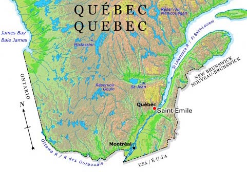
Saint-Émile, Quebec, is a former city and a current sector of Quebec City. On 1 January 2002, the city of Saint-Émile was amalgamated into Quebec City alongside several other cities and municipalities in the region. Now, Saint-Émile identifies the sector of Quebec City which corresponds to the old city of Saint-Émile’s territory.
"https://d3d0lqu00lnqvz.cloudfront.net/media/media/2356d51d-54fe-4333-830f-9d6ab470d821.jpg" // resources/views/front/categories/view.blade.php
https://d3d0lqu00lnqvz.cloudfront.net/media/media/2356d51d-54fe-4333-830f-9d6ab470d821.jpg