
Browse "Cities & Populated Places"
-
Article
Bowmanville
Bowmanville, Ontario, population centre, population 39,371 (2016 census), 35,168 (2011 census). Bowmanville is located 25 km east of Toronto on Highway 401. Originally called Darlington Mills, it was renamed in the 1830s after Charles Bowman, the principal landowner. Bowmanville was incorporated as a village in 1852 and as a town in 1857. In January 1974, Bowmanville became part of the town of Newcastle (now Clarington) in the new Regional Municipality of Durham. Home of diverse manufacturers in the 19th century, Bowmanville now serves as a dormitory for Toronto and Oshawa.
"https://d3d0lqu00lnqvz.cloudfront.net/media/new_article_images/Bowmanville/POWcampBowmanville.jpg" // resources/views/front/categories/view.blade.php
https://d3d0lqu00lnqvz.cloudfront.net/media/new_article_images/Bowmanville/POWcampBowmanville.jpg
-
Article
Bradford West Gwillimbury
Bradford West Gwillimbury, Ontario, incorporated as a town in 1991, population 42,880 (2021 census), 35,325 (2016 census). The town of Bradford West Gwillimbury consists of the former town of Bradford (incorporated in 1960), most of the lands of the former township of West Gwillimbury, and a small portion of land from the township of Tecumseth. The town is located about 60 km north of downtown Toronto.
"https://d3d0lqu00lnqvz.cloudfront.net/media/media/dad4572f-2b1a-4403-8b17-6072735c63c9.jpg" // resources/views/front/categories/view.blade.php
https://d3d0lqu00lnqvz.cloudfront.net/media/media/dad4572f-2b1a-4403-8b17-6072735c63c9.jpg
-
Article
Brampton
Brampton, Ontario, incorporated as a city in 1974, population 656,480 (2021 census), 593,638 (2016 census). The city of Brampton was created by the amalgamation of the Town of Brampton, the southern half of Chinguacousy Township, and portions of the Town of Mississauga and Toronto Gore Township. Located northwest of Toronto, Brampton is part of the Regional Municipality of Peel. It is located within the Credit and Humber River watersheds. The city of Brampton is known for its ethnocultural diversity: 80.6% of the population identifies as a visible minority. Throughout history, the Brampton area has been home to different Indigenous groups, namely the Wendat (Huron), Haudenosaunee and Anishinaabeg, including the Mississaugas of the Credit. The land is covered by the Ajetance Purchase (1818).
"https://d3d0lqu00lnqvz.cloudfront.net/media/new_article_images/Brampton/1BramptonPicture.jpg" // resources/views/front/categories/view.blade.php
https://d3d0lqu00lnqvz.cloudfront.net/media/new_article_images/Brampton/1BramptonPicture.jpg
-
Article
Brandon
Brandon, Manitoba, incorporated as a city in 1882, population 51,313 (2021 census), 48,883 (2016 census). The City of Brandon, the province's second-largest city and economic hub of its southwestern region, is located on the Assiniboine River, 197 km west of Winnipeg.
"https://d3d0lqu00lnqvz.cloudfront.net/media/media/4112eb2b-9753-45c6-b355-904d9a519a46.jpg" // resources/views/front/categories/view.blade.php
https://d3d0lqu00lnqvz.cloudfront.net/media/media/4112eb2b-9753-45c6-b355-904d9a519a46.jpg
-
Article
Brantford
Brantford, ON, incorporated as a city in 1877, population 97,496 (2016 census), 93,650 (2011 census). The City of Brantford is located on the Grand River, 104 km southwest of Toronto. It is home to several manufacturing industries, educational institutions and heritage sites.
"https://d3d0lqu00lnqvz.cloudfront.net/media/media/4e9bdb40-6a17-4aed-8166-559a7b871ae7.jpg" // resources/views/front/categories/view.blade.php
https://d3d0lqu00lnqvz.cloudfront.net/media/media/4e9bdb40-6a17-4aed-8166-559a7b871ae7.jpg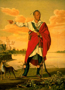
-
Article
Brighton
Brighton, Ont, incorporated as a municipality in 2001, population 10 928 (2011c), 10 253 (2006c). The Municipality of Brighton is located 12 km west of Trenton, near Lake Ontario.
"https://thecanadianencyclopedia.ca/images/tce_placeholder.jpg?v=e9dca980c9bdb3aa11e832e7ea94f5d9" // resources/views/front/categories/view.blade.php
https://thecanadianencyclopedia.ca/images/tce_placeholder.jpg?v=e9dca980c9bdb3aa11e832e7ea94f5d9
-
Article
British Columbia and Confederation
The colony of British Columbia was founded in 1858 in response to the Fraser River Gold Rush. (See also The Fraser River Gold Rush and the Founding of British Columbia.) The colony established representative government in 1864 and merged with the colony of Vancouver Island in 1866. In May 1868, Amor De Cosmos formed the Confederation League to bring responsible government to BC and to join Confederation. In September 1868, the Confederation League passed 37 resolutions outlining the terms for a union with the Dominion of Canada. The terms were passed by both the BC assembly and the federal Parliament in 1871. The colony joined Canada as the country’s sixth province on 20 July 1871. The threat of American annexation, embodied by the Alaska purchase of 1867, and the promise of a railway linking BC to the rest of Canada, were decisive factors.
"https://d3d0lqu00lnqvz.cloudfront.net/media/media/1f3712f0-f1ac-4fba-a093-ff4c7cfec856.jpg" // resources/views/front/categories/view.blade.php
https://d3d0lqu00lnqvz.cloudfront.net/media/media/1f3712f0-f1ac-4fba-a093-ff4c7cfec856.jpg
-
Article
Brockville
Brockville, Ont, incorporated as a city in 1962, population 21 870 (2011c), 21 957 (2006c). The City of Brockville is located on the St Lawrence River, 80 km east of Kingston.
"https://d3d0lqu00lnqvz.cloudfront.net/media/media/22f08ba6-1b15-4ad2-8735-6081fd45a518.jpg" // resources/views/front/categories/view.blade.php
https://d3d0lqu00lnqvz.cloudfront.net/media/media/22f08ba6-1b15-4ad2-8735-6081fd45a518.jpg
-
Article
Brooks
Brooks, Alta, incorporated as a city in 2005, population 13 676 (2011c), 12 508 (2006c). The City of Brooks is located 185 km southeast of Calgary on the Trans-Canada Highway.
"https://thecanadianencyclopedia.ca/images/tce_placeholder.jpg?v=e9dca980c9bdb3aa11e832e7ea94f5d9" // resources/views/front/categories/view.blade.php
https://thecanadianencyclopedia.ca/images/tce_placeholder.jpg?v=e9dca980c9bdb3aa11e832e7ea94f5d9
-
Article
Buckingham
Originally incorporated as a village in 1855 and as a city in 1890, it adopted the name of the township in which it is situated. The name is a historical reminder of the role played in 19th-century British politics by George Nugent Temple Grenville, 1st Marquis of Buckingham (1753-1813).
"https://thecanadianencyclopedia.ca/images/tce_placeholder.jpg?v=e9dca980c9bdb3aa11e832e7ea94f5d9" // resources/views/front/categories/view.blade.php
https://thecanadianencyclopedia.ca/images/tce_placeholder.jpg?v=e9dca980c9bdb3aa11e832e7ea94f5d9
-
Article
Buckland
Buckland, Sask, incorporated as a rural municipality in 1911, population 3658 (2011c), 3429 (2006c). The Rural Municipality of Buckland is named for the deer that were once common in the area.
"https://thecanadianencyclopedia.ca/images/tce_placeholder.jpg?v=e9dca980c9bdb3aa11e832e7ea94f5d9" // resources/views/front/categories/view.blade.php
https://thecanadianencyclopedia.ca/images/tce_placeholder.jpg?v=e9dca980c9bdb3aa11e832e7ea94f5d9
-
"https://thecanadianencyclopedia.ca/images/tce_placeholder.jpg?v=e9dca980c9bdb3aa11e832e7ea94f5d9" // resources/views/front/categories/view.blade.php
https://thecanadianencyclopedia.ca/images/tce_placeholder.jpg?v=e9dca980c9bdb3aa11e832e7ea94f5d9
-
Article
Burin
Burin, NL, incorporated as a town in 1950, population 2424 (2011c), 2483 (2006c). The Town of Burin is located along a protected inlet of Placentia Bay on the southeast coast of the Burin Peninsula.
"https://thecanadianencyclopedia.ca/images/tce_placeholder.jpg?v=e9dca980c9bdb3aa11e832e7ea94f5d9" // resources/views/front/categories/view.blade.php
https://thecanadianencyclopedia.ca/images/tce_placeholder.jpg?v=e9dca980c9bdb3aa11e832e7ea94f5d9
-
Article
Burnaby
Burnaby, BC, incorporated as a city in 1992, population 249,125 (2021 census), 232,755 (2016 census). Burnaby adjoins Vancouver on the west, Coquitlam on the east and New Westminster on the southeast. Named after Robert Burnaby, a businessman and legislator of the 1860s, it features Burnaby Mountain (365 m), Burnaby Lake, the Fraser River and Burrard Inlet. Burnaby was a district municipality for one hundred years before being granted civic status in 1992. It is governed by a mayor and eight councillors and is a member Metro Vancouver. (See also Municipal Government in Canada.)
"https://d3d0lqu00lnqvz.cloudfront.net/media/media/2bd7362f-7692-4d30-b07f-0cde82e5492a.jpg" // resources/views/front/categories/view.blade.php
https://d3d0lqu00lnqvz.cloudfront.net/media/media/2bd7362f-7692-4d30-b07f-0cde82e5492a.jpg
-
Article
Burns Lake
Burns Lake, BC, incorporated as a village in 1923, population 2029 (2011c), 2107 (2006c). The Village of Burns Lake is located on Highway 16 in the geographical centre of British Columbia on the Nechako Plateau, 226 km west of Prince George.
"https://thecanadianencyclopedia.ca/images/tce_placeholder.jpg?v=e9dca980c9bdb3aa11e832e7ea94f5d9" // resources/views/front/categories/view.blade.php
https://thecanadianencyclopedia.ca/images/tce_placeholder.jpg?v=e9dca980c9bdb3aa11e832e7ea94f5d9