
Browse "Cities & Populated Places"
-
Article
Prince George
Prince George, British Columbia, incorporated as a city in 1915, population 76,708 (2021 census), 74,003 (2016 census). Prince George is the largest city in the northern part of the province. It is situated in the geographical centre of British Columbia at the junction of the Nechako and Fraser rivers. Prince George was founded on the traditional territory of the Lheidli T'enneh, a sub-group of the Dakelh or Carrier Dene. The Dakelh aided Alexander Mackenzie on his journey to the Pacific coast in 1793.
"https://d3d0lqu00lnqvz.cloudfront.net/media/media/5cada4a2-0076-4515-b8d0-dfad91ba5c9a.jpg" // resources/views/front/categories/view.blade.php
https://d3d0lqu00lnqvz.cloudfront.net/media/media/5cada4a2-0076-4515-b8d0-dfad91ba5c9a.jpg
-
Article
Prince Rupert
Prince Rupert, BC, incorporated as a city in 1910, population 12,300 (2021 census), 12,220 (2016 census). The City of Prince Rupert is located on Kaien Island, at the mouth of the Skeena River in the Coast Mountains of British Columbia. It is Canada's wettest city, with an average of 2,619 mm of precipitation falling each year. Prince Rupert marks western end of the Yellowhead Trans-Canada Highway and, as Canada's deepest ice-free seaport, a link between the lower United States, Vancouver and Alaska (see also Iconic Highways in Canada). For these reasons it is the industrial, commercial and institutional centre for BC's Northwest Coast.
"https://d3d0lqu00lnqvz.cloudfront.net/media/media/adb7f8d5-a8d7-465c-8567-2d8d0de2e468.jpg" // resources/views/front/categories/view.blade.php
https://d3d0lqu00lnqvz.cloudfront.net/media/media/adb7f8d5-a8d7-465c-8567-2d8d0de2e468.jpg
-
Article
Princeton
Princeton, BC, incorporated as a town in 1978, population 2724 (2011c), 2780 (2006c). The Town of Princeton is located at the junction of the Tulameen and Similkameen rivers, 114 km west of PENTICTON.
"https://thecanadianencyclopedia.ca/images/tce_placeholder.jpg?v=e9dca980c9bdb3aa11e832e7ea94f5d9" // resources/views/front/categories/view.blade.php
https://thecanadianencyclopedia.ca/images/tce_placeholder.jpg?v=e9dca980c9bdb3aa11e832e7ea94f5d9
-
Article
Prud'homme
Prud'homme, Saskatchewan, incorporated as a village in 1922, population 167 (2016 census), 172 (2011 census). The village of Prud'homme is located about 45 km northeast of Saskatoon. Prud'homme is the hometown of Jeanne Sauvé, a former cabinet minister in the Pierre Trudeau government, the first woman to hold the position of Speaker of the House of Commons and the first woman to act as Governor General of Canada.
"https://thecanadianencyclopedia.ca/images/tce_placeholder.jpg?v=e9dca980c9bdb3aa11e832e7ea94f5d9" // resources/views/front/categories/view.blade.php
https://thecanadianencyclopedia.ca/images/tce_placeholder.jpg?v=e9dca980c9bdb3aa11e832e7ea94f5d9
-
Article
Pugwash
Pugwash, NS, incorporated as a village in 1948, population 744 (2011c), 784 (2006c). Pugwash is located 65 km northwest of TRURO, at the mouth of the Pugwash River.
"https://thecanadianencyclopedia.ca/images/tce_placeholder.jpg?v=e9dca980c9bdb3aa11e832e7ea94f5d9" // resources/views/front/categories/view.blade.php
https://thecanadianencyclopedia.ca/images/tce_placeholder.jpg?v=e9dca980c9bdb3aa11e832e7ea94f5d9
-
Article
Qualicum Beach
Qualicum Beach, BC, incorporated as a town in 1983, population 8687 (2011c), 8502 (2006c). The Town of Qualicum Beach is located on the east coast of VANCOUVER ISLAND, 48 km north of NANAIMO. The name Qualicum is a Straits Salish (see SALISH, CENTRAL COAST) word meaning "where the dog salmon run.
"https://thecanadianencyclopedia.ca/images/tce_placeholder.jpg?v=e9dca980c9bdb3aa11e832e7ea94f5d9" // resources/views/front/categories/view.blade.php
https://thecanadianencyclopedia.ca/images/tce_placeholder.jpg?v=e9dca980c9bdb3aa11e832e7ea94f5d9
-
Article
Quebec Act, 1774
The Quebec Act received royal assent on 22 June 1774. It revoked provisions in the Royal Proclamation of 1763 that had aimed to assimilate the French-Canadian population under English rule. The Quebec Act was put into effect on 1 May 1775. It was passed to gain the loyalty of the French-speaking majority of the Province of Quebec. Based on recommendations from Governors James Murray and Guy Carleton, the Act guaranteed the freedom of worship and restored French property rights. However, the Act was unpopular in the Thirteen American Colonies and was one of the causes of the American Revolutionary War (1775–83). It was followed by the Constitutional Act in 1791. This is the full-length entry about the Quebec Act of 1774. For a plain language summary, please see The Quebec Act, 1774 (Plain-Language Summary).
"https://d3d0lqu00lnqvz.cloudfront.net/media/media/bcf0dcc3-ce34-4098-8543-00bcccbaabe0.jpg" // resources/views/front/categories/view.blade.php
https://d3d0lqu00lnqvz.cloudfront.net/media/media/bcf0dcc3-ce34-4098-8543-00bcccbaabe0.jpg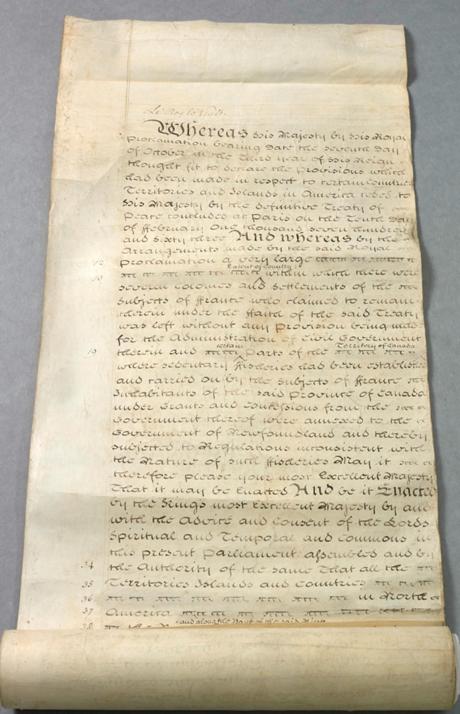
-
Article
Queens
Queens, NS, incorporated as a regional municipality in 1996, population 10 917 (2011c), 11 177 (2006c). The Region of Queens Municipality is located approximately 150 km southwest of Halifax.
"https://d3d0lqu00lnqvz.cloudfront.net/media/media/22724662-cbf7-461d-9649-5a5c6a3a3b7f.jpg" // resources/views/front/categories/view.blade.php
https://d3d0lqu00lnqvz.cloudfront.net/media/media/22724662-cbf7-461d-9649-5a5c6a3a3b7f.jpg
-
Article
Quinte West
Long occupied by Indigenous peoples, at the time of first European contact, the Mississauga (Ojibwa) occupied the region.
"https://d3d0lqu00lnqvz.cloudfront.net/media/media/ee432d3b-83bf-4fa4-acd0-c86635530374.jpg" // resources/views/front/categories/view.blade.php
https://d3d0lqu00lnqvz.cloudfront.net/media/media/ee432d3b-83bf-4fa4-acd0-c86635530374.jpg
-
Article
Quispamsis
Quispamsis, NB, incorporated as a town in 1998, population 17 886 (2011c), 15 239 (2006c). The Town of Quispamsis is located 22 km northeast of SAINT JOHN along the Kennebecasis River.
"https://thecanadianencyclopedia.ca/images/tce_placeholder.jpg?v=e9dca980c9bdb3aa11e832e7ea94f5d9" // resources/views/front/categories/view.blade.php
https://thecanadianencyclopedia.ca/images/tce_placeholder.jpg?v=e9dca980c9bdb3aa11e832e7ea94f5d9
-
Article
Raymond
Raymond, Alberta, incorporated as a town in 1903, population 3,708 (2016 census), 3,743 (2011 census). The town of Raymond is located in southern Alberta, approximately 35 km south of Lethbridge. In the early 1900s the area was settled by Mormons and Japanese labourers (see also Japanese Canadians). The Raymond Stampede, Canada’s first rodeo, has been held in the town since 1902.
"https://d3d0lqu00lnqvz.cloudfront.net/media/media/073c1dc8-391d-4239-808d-814a185846c0.jpg" // resources/views/front/categories/view.blade.php
https://d3d0lqu00lnqvz.cloudfront.net/media/media/073c1dc8-391d-4239-808d-814a185846c0.jpg
-
Article
Rebellion in Lower Canada (The Patriots' War)
In 1837 and 1838, French Canadian militants in Lower Canada took up arms against the British Crown in a pair of insurrections. The twin rebellions killed more than 300 people. They followed years of tensions between the colony’s anglophone minority and the growing, nationalistic aspirations of its francophone majority. The rebels failed in their campaign against British rule. However, their revolt led to political reform, including the unified Province of Canada and the introduction of responsible government. The rebellion in Lower Canada, which is also known as the Patriots' War (la Guerre des patriotes), also gave French Canadians one of their first nationalist heroes in Louis-Joseph Papineau.
"https://d3d0lqu00lnqvz.cloudfront.net/media/media/37aadc48-3f88-4946-a9aa-0d2ad30495cd.jpg" // resources/views/front/categories/view.blade.php
https://d3d0lqu00lnqvz.cloudfront.net/media/media/37aadc48-3f88-4946-a9aa-0d2ad30495cd.jpg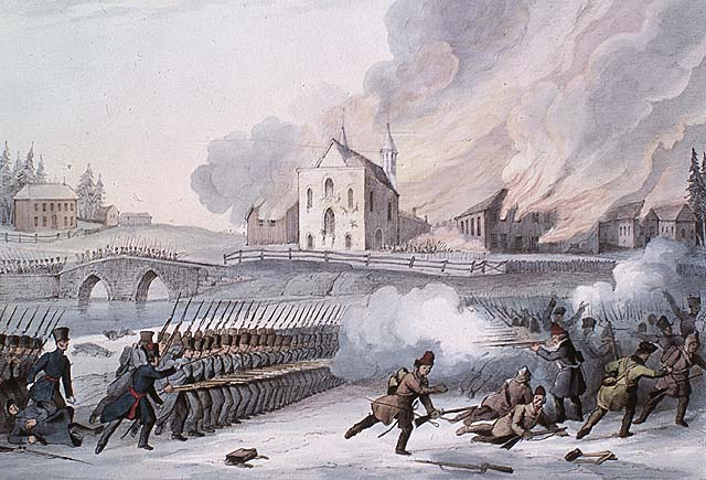
-
Article
Red Deer
Red Deer, Alberta, incorporated as a city in 1913, population 100,844 (2021 census), 100,418 (2016 census). The city of Red Deer is located on the Red Deer River, 150 km south of Edmonton. The Cree applied the name “Elk” to the river, but Scottish fur traders appear to have confused elk with the red deer of their homeland.
"https://thecanadianencyclopedia.ca/images/tce_placeholder.jpg?v=e9dca980c9bdb3aa11e832e7ea94f5d9" // resources/views/front/categories/view.blade.php
https://thecanadianencyclopedia.ca/images/tce_placeholder.jpg?v=e9dca980c9bdb3aa11e832e7ea94f5d9
-
Article
Red River Resistance
The Red River Resistance (also known as the Red River Rebellion) was an uprising in 1869–70 in the Red River Colony. The resistance was sparked by the transfer of the vast territory of Rupert’s Land to the new Dominion of Canada. The colony of farmers and hunters, many of them Métis, occupied a corner of Rupert’s Land and feared for their culture and land rights under Canadian control. The Métis mounted a resistance and declared a provisional government to negotiate terms for entering Confederation. The uprising led to the creation of the province of Manitoba, and the emergence of Métis leader Louis Riel — a hero to his people and many in Quebec, but an outlaw in the eyes of the Canadian government.
"https://d3d0lqu00lnqvz.cloudfront.net/media/media/f0a1f84f-c420-4038-8815-42587e295b75.jpg" // resources/views/front/categories/view.blade.php
https://d3d0lqu00lnqvz.cloudfront.net/media/media/f0a1f84f-c420-4038-8815-42587e295b75.jpg
-
Article
Redcliff
Redcliff, Alta, incorporated as a town in 1912, population 5588 (2011c), 5116 (2006c). The Town of Redcliff is located adjacent to MEDICINE HAT and named for the outcroppings of red shale occurring along the banks of the nearby South Saskatchewan River.
"https://thecanadianencyclopedia.ca/images/tce_placeholder.jpg?v=e9dca980c9bdb3aa11e832e7ea94f5d9" // resources/views/front/categories/view.blade.php
https://thecanadianencyclopedia.ca/images/tce_placeholder.jpg?v=e9dca980c9bdb3aa11e832e7ea94f5d9