Share on Facebook
 Share on X
 Share by Email
 Share on Google Classroom
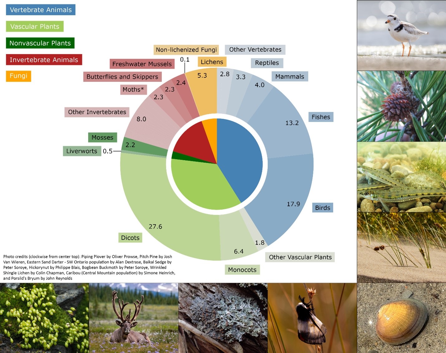
Key Biodiversity Areas (KBAs) are sites that play an outsized role in supporting the survival of species and ecosystems around the world. They are identified through rigorous scientific assessment using internationally standardized criteria developed by the International Union for Conservation of Nature (IUCN). Canada has about 800 KBAs, including candidate sites. They are found across marine, freshwater, terrestrial and subterranean environments, spotlighting key sites for iconic species like polar bears and puffins, and for lesser-known Canadian biodiversity, like slugs, lichens and rare dune ecosystems. KBAs recognize the diversity and significance of Canada’s nature, helping governments, Indigenous communities, conservation organizations, researchers and others prioritize areas for conservation.
Development
The Key Biodiversity Area (KBA) initiative was developed by the International Union for Conservation of Nature (IUCN) to create a globally consistent, science-based approach for identifying sites important for preventing the extinction of species and ecosystems (see Extinct Animals in Canada, Extinct Plants in Canada). The initiative was formally launched in 2016 when the Global Standard for the Identification of Key Biodiversity Areas was published. This standard provides a set of standardized criteria and methods for identifying KBAs across all species and ecosystems, building on decades of earlier, taxon-specific approaches like Important Bird and Biodiversity Areas, Alliance for Zero Extinction sites and Important Plant Areas.
Canada was one of the first countries to adopt KBAs and remains a global leader among the 40+ countries with national KBA programs. KBA identification in Canada is led by three non-profit organizations — Wildlife Conservation Society Canada, Birds Canada and NatureServe Canada — and involves a large partnership of conservation organizations, governments, academics and Indigenous communities and organizations from across the country.
Did you know?
A designation for geologically significant sites, Key Geoheritage Area (KGA), was added at the IUCN World Conservation Congress in Abu Dhabi in October 2025. Areas with unique rocks, minerals, fossils, sediments, soils, landforms and landscapes will be among the candidates for this designation.
Identifying KBAs
To be recognized as a Key Biodiversity Area (KBA), a site must meet one or more specific quantitative criteria that show the area is particularly important for supporting threatened (see Endangered Animals in Canada, Endangered Plants in Canada) and rare species and ecosystems, significant biological processes or world-class ecological integrity.
Showing that a site meets KBA criteria typically involves comparing the population of a species or the extent of an ecosystem at the site to an estimate of the global population or extent. For example, the Wood Buffalo KBA, in northern Alberta, holds about 18 per cent of mature American bison (Bos bison) in the world. Because this site supports over 10 per cent of the global population for a single species, it meets criteria for geographically restricted species (KBA criterion B1) and can be recognized as a KBA. As another example, the Marble Ridge Alvar KBA, in Manitoba, holds about 64 per cent of the entire Northern Plains Alvar ecosystem, which meets KBA criterion B4. The National Standard for the Identification of Key Biodiversity Areas in Canada also allows the identification of KBAs for sites of national significance, allowing KBAs to be identified using the Canadian population as a comparison instead of the global population (see Animals Only Found in Canada). For example, the Creston Valley KBA, in British Columbia, is the only place in Canada where a unique population of northern leopard frogs (Lithobates pipiens pop. 1) can be found, qualifying this site as a KBA for threatened species (KBA criterion A1e). Every KBA proposal is founded in high-quality data and expert input that have undergone detailed review.
The process of identifying KBAs in Canada is collaborative, drawing on a network of hundreds of scientists, conservation organizations, Indigenous partners, governments and naturalists from across the country. This bottom-up process is especially important in Canada, where regional expertise and traditional knowledge provide critical information on where species and ecosystems remain and continue to thrive across the country's large and diverse landscapes and seascapes.
Purpose and Objectives
Key Biodiversity Areas (KBAs) highlight a wide diversity of places. Some sites, like Fraser River Estuary in British Columbia or Long Point Peninsula and Marshes in Ontario, are well-known internationally as hotspots of biodiversity in Canada. Many other KBAs are unrecognized outside of small or niche naturalist circles. KBAs also highlight a huge number of species and ecosystems, spotlighting rare pieces of nature that are uniquely Canadian (see Animals Only Found in Canada). From the most remote Canadian north to greenspaces in the middle of Canada’s biggest urban centers (see Urban Forests in Canada), every KBA is a site that plays an exceptional role in supporting nature.
KBA information is used across Canada to inform planning, policy and conservation (see Species at Risk Legislation in Canada, Protected Areas of Canada). Even though a KBA designation doesn’t automatically change how a site is managed or used, the information is a tool for informing and supporting conservation action and decision-making. The KBA dataset is characterized by how it's built and maintained: a collaborative, expert-driven identification process grounded in scientific research with international recognition; clearly documented methods and extensive supporting metadata for every site; regular review and updates; and a publicly accessible dataset anyone can consult. Together, these make KBA information broadly trusted as a basis for decision-making by various sectors and governments.
KBA information shapes real decisions. Governments use it to help track progress on commitments, community groups use KBA information to help advocate for better protection of sites, and Indigenous communities and organizations draw on KBA data to support proposals for Indigenous Protected and Conserved Areas and for Indigenous-led monitoring.

Examples of How KBA Information Is Used in Canada
|
Sector |
Purpose |
Examples |
|---|---|---|
|
Government & Policy |
Informing national, provincial and municipal decisions |
Supporting Canada's biodiversity commitments through Canada's 2030 Nature Strategy, Environment and Climate Change Canada’s Protected Areas Strategy, ecological corridor planning, and related initiatives. Used by Quebec as one of several indicators of biodiversity value for identifying and assessing Other Effective Area-Based Conservation Measures (OECMs). |
|
Municipal Planning & Local Stewardship |
Guiding local protection and site management |
Capital Regional District (BC) and the District of Oak Bay use KBAs to support protection and management decisions. City of Winnipeg uses the Living Prairie Museum KBA designation to strengthen long-term stewardship and public recognition. Community groups in British Columbia used KBA information to help halt a proposed development affecting Skookumchuck Prairie KBA. |
|
Funders & Foundations |
Helping direct conservation investment |
Weston Family Foundation identifies KBAs as one of its top three environmental stewardship funding priorities. Tree Canada's National Greening Program uses KBAs to target priority areas for restoration and ecological connectivity across Canada. |
|
Conservation NGOs |
Strengthening prioritization and planning |
Nature Conservancy of Canada (NCC) uses KBAs to inform land acquisition and spatial planning. BC Nature uses KBAs to support local advocacy and prioritize monitoring. |
|
Indigenous-Led Conservation & Stewardship |
Supporting Indigenous priorities, knowledge and leadership |
Swan River First Nation integrates KBA data into cumulative effects modelling and nature-directed planning. Mi'gmawe'l Tplu'taqnn Inc. uses KBA information to support Indigenous Protected and Conserved Areas (IPCAs) planning and proposals in New Brunswick. First Nations in Canada use KBAs to inform responses to consultation and development proposals. |
|
Global Commitments |
Connecting local action to international goals |
KBAs support implementation of multiple targets under the Kunming-Montreal Global Biodiversity Framework. |