Share on Facebook
 Share on X
 Share by Email
 Share on Google Classroom
Ontario is a Canadian province bounded by Manitoba to the west, Hudson Bay to the north, Québec to the east, and New York, the Great Lakes, Michigan and Minnesota to the south. The province was founded on parts of the traditional territories of the Ojibwa, Odawa, Potawatomi, Algonquin, Mississauga, Haudenosaunee, Neutral, Wendat, Cree, Oji-Cree and Métis. The land is now governed by 46 treaties, including the Upper Canada, Williams and Robinson treaties, as well as Treaties 3, 5 and 9.. As of the 2021 census, Ontario had 14,223,942 residents, making it the most populous province or territory in Canada. Ontario was one of the founding members of Confederation, along with New Brunswick, Nova Scotia and Québec, in 1867. The capital city of Ontario is Toronto. Doug Ford is the province’s current premier, leading a majority Progressive Conservative government.
Geography

Ontario is divided by three of Canada’s seven physiographic regions. These three regions are the Hudson Bay Lowlands, the Canadian Shield and the St. Lawrence Lowlands. Agriculture, as well as most of the population, is concentrated in the south.
Ontario has the most varied landscape of any Canadian province. Two-thirds of the province lies under the Canadian Shield. The Canadian Shield covers most of the North, with the exception of the Hudson Bay Lowlands. To the east lies the eastern Ontario plain, between the Ottawa and St. Lawrence rivers. To the west, from Kingston on, there are belted rolling hills and plains. Extreme southwestern Ontario is comparatively flat. The Niagara Escarpment extends from Niagara north to Tobermory, and through Manitoulin Island in Georgian Bay.
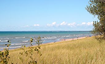
There are over 250,000 lakes in Ontario, which contain approximately one-fifth of the world’s fresh water supply. Except for Lake Michigan, Ontario includes a portion of all the Great Lakes (i.e., lakes Superior, Huron, Erie and Ontario). Other major lakes include Lake Nipigon (4,848 km2), Lake of the Woods (3,150 km 2 and spanning the Minnesota and Manitoba borders) and Lac Seul (1,657 km 2). (See also Geography of Ontario.)
History
Indigenous People
(courtesy Native Land Digital / Native-Land.ca)
The first residents of present-day Ontario arrived during the last ice age, approximately 11,000 years ago. As the ice retreated, Paleo-American inhabitants moved into the northern region of the province. For many years, Indigenous people probably lived by fishing and hunting; deer, elk, bear and beaver could be found in the south, and caribou in the north. By 1000 BCE, pottery had been introduced, and archaeological sites show a far-flung trading system with importations from as far as the Gulf of Mexico. By 800 CE, certain tribes living south of the Canadian Shield, including the Wendat and the Haudenosaunee, were well-established farmers, growing primarily corn, beans and squash.
When Europeans arrived in the early 1600s, the Cree inhabited what is now Northern Ontario, with the Ojibwa, Odawa and Algonquin living south of them, along the northern shore of Lake Superior and into modern-day Québec. Further south still, around Georgian Bay, were the Wendat, and in the southernmost tip of today’s province were the Potawatomi and the people known as the Neutral. The nations making up the Haudenosaunee confederacy (the Mohawk, Onondaga, Oneida, Cayuga and Seneca) lived south of Lake Ontario, in the Finger Lakes region of present-day New York State.
Exploration and Fur Trade
The first Europeans known to have approached the present frontiers of Ontario were Henry Hudson, who explored the coast of James Bay, and Étienne Brûlé and Samuel de Champlain, who travelled along the Ottawa River in 1613 and reached the centre of the province in 1615. Brûlé was likely the first European to see Lakes Huron and Ontario. The French allied themselves with the Wendat, Innu and Algonquin, using already established Indigenous trade networks to move furs across the region. Similarly, the Dutch and English allied themselves with the Haudenosaunee. Each side armed their Indigenous partners with guns. Given their position between the abundant furs of the Canadian Shield and the south, the Wendat prospered in the early decades of European fur trade. Wishing to gain access to this trade themselves, the Haudenosaunee staged a series of raids on Wendat villages throughout the 17th century (see Iroquois Wars). Between 1642 and 1649, these raids resulted in the dispersal of the Wendat. Some fled to Québec while others moved south to join the people known as the Neutral. However, Haudenosaunee raids on Neutral villages in 1650–51 meant they too were scattered, being absorbed into other Indigenous communities further west and south.
At the same time, despite the hostility of the Haudenosaunee, the French continued their penetration of the Great Lakes region, utilizing both the Ottawa–French River–Lake Huron route to the west and the St. Lawrence–Great Lakes path.
French explorer René-Robert Cavelier de La Salle built and sailed the Griffon on the Great Lakes, and the Ontario region became a vital link between the French settlements in Québec and their fur trading posts on the Mississippi. During the 18th century, the main French posts in the Great Lakes region were Fort Frontenac (Kingston), Fort Niagara, Fort Detroit and Fort Michilimackinac.
France’s rivals, the British, did not control the region until 1758–59 when they burned Fort Frontenac and captured Fort Niagara. British occupation was not secure until the Indigenous allies of the French were defeated after an uprising in 1763–64. The Great Lakes region also served as a base of operations for British forces during the American Revolution. A series of bloody campaigns and raids did not shake the British hold over their Great Lakes forts, but did result in the arrival of Loyalist and Haudenosaunee refugees displaced from the American frontier. The Treaty of Paris (1783) divided the Great Lakes down the middle and created the southern boundary of what is now Ontario.
American Revolution and Settlement
The modern settlement of Ontario began with the arrival of some 6,000 to 10,000 Loyalists during and after the American Revolution. After them came other Americans, attracted by cheap land; crown land was available for sixpence an acre plus survey costs and an oath of allegiance. Under the Constitutional Act of 1791, the old Province of Québec was divided and Upper Canada created.
A regular colonial government was established, with a lieutenant-governor, an elected legislative assembly and appointed legislative and executive councils. The first lieutenant-governor was John Graves Simcoe, an English veteran of the American Revolution, who aimed to turn Upper Canada into a bastion of the British Crown in the heart of the continent.
War of 1812
Upper Canada continued to mark the northern fringe of the American frontier, but by 1812 approximately 80 per cent of the estimated 100,000 settlers in Southern Ontario were of American origin. When the War of 1812 broke out with the United States, the attitude of parts of the province’s population proved highly ambivalent, and a few Upper Canadians actually sided with and fought alongside the invaders.
The British army, with assistance from Indigenous people and local militia, succeeded in defending most of the province, repelling American invasions along the Niagara frontier in 1812 (Queenston Heights) and 1813 (Beaver Dams and Stoney Creek) (see also First Nations and Métis Peoples in the War of 1812). In 1813, American forces thrust into southwestern Ontario and raided the provincial capital, York (Toronto), where the government buildings were burned. After several more bloody battles in 1814, the war drew to an end. The peace treaty that ended the war stipulated that the Americans and British each hand back what they had conquered, and the boundary remained unchanged.
Treaties
(courtesy Native Land Digital / Native-Land.ca)
By the mid-1830s, the colonial government had signed treaties covering most arable land in Upper Canada (now the Great Lakes region of Ontario). To the government, treaties meant that First Nations surrendered their land in exchange for goods and other promises. Gradually, treaties came to include the creation of reserves, or plots of land set aside for First Nations to live on. These reserves represented fractions of each nation’s traditional territory. The agreements known as the Upper Canada Treaties constitute a number of agreements signed between 1764 and 1862, many of which provided one-time payments to First Nations without establishing reserves. Other treaties in the province include: the Robinson-Huron and Robinson-Superior Treaties (1850), the Williams Treaties (1923), Treaty 3 (1873–75) and Treaty 9 (signed in stages in the early 1900s, starting in 1905). (See also Indigenous Peoples: Treaties; Numbered Treaties.)
Immigration
Between 1825 and 1842, the population of Upper Canada tripled to 450,000, and by 1851 it had doubled again. Most of the immigrants came from the British Isles, made up roughly of 20 per cent English, 20 per cent Scottish and 60 per cent Irish immigrants. Settlement generally spread from south to north, moving away from the lakes as land along them became settled. Accessibility to land away from the lakes depended on roads — usually of terrible quality — many of which were built by the settlers themselves.
Rebellions of 1837
Rampant land speculation added to the irregularity of early settlement patterns. Southern Ontario’s fertile land was substantially occupied by the mid-1850s, by which time the form of government had changed again. In the aftermath of the Rebellions of 1837, led in Upper Canada by Toronto “firebrand” William Lyon Mackenzie, the British government brought Upper and Lower Canada together in the united Province of Canada.
Responsible Government and Confederation
A further decade of fractious politics resulted in a measure of responsible government in 1848–49, by which time immigration, combined with a high birthrate, had raised Upper Canada’s population to about 60,000 more than its partner, Lower Canada. The agitation for representation by population was led by George Brown. Representation by population would mean that Upper Canada would receive additional representation in the Legislature, and this movement led to the increasing paralysis of the province’s political system. The crisis was finally resolved in 1864 by the formation of a joint-party regime (see Great Coalition) to seek a union of the British North American colonies. This Confederation was gained in 1867, and Ontario became a province of the new Dominion of Canada. (See also Ontario and Confederation.)
Development

In the 1850s, Ontario’s economy was primarily agricultural with an emphasis on wheat growing. Over time the balance shifted to dairy, fruit and vegetable farming. At the same time there was a drift away from farming areas, as emigration to the United States, the Canadian West or to cities increased. Urban and industrial growth increased from the 1850s through the 1860s with the development of textiles and metalworking, farm implements and machinery. Toronto in particular grew as both a railway and manufacturing centre, and as the provincial capital.
Ontario’s successive governments thereafter took up developing the province’s natural resources —lumber, mines and later, hydroelectricity. There was a lengthy series of quarrels with the federal government over patronage, water power and the northern boundaries of the province — a problem settled in 1889, at the expense of Manitoba, by confirming Ontario’s western boundary at the Lake of the Woods. The final boundary was drawn in 1912.
Demographics
Language and Ethnicity
The majority of Ontario’s population (65.1 per cent) identifies English as their mother tongue, followed by French (3.3 per cent) according to the 2021 census. Toronto has the highest number of non-native English or French speakers, with 42.1 per cent of the population reporting a non-official language as their mother tongue. Urban centres with the highest share of French speakers are Sudbury (33.1 per cent) and Ottawa (37.8 per cent).
Ontario has an ethnically diverse population. According to the 2021 Census, 62.2 per cent of the province’s population is of European origin. Among this group, those who claim British Isles ancestry are the largest, followed by German, French, and Italian. Indigenous people (including First Nations, Métis and Inuit) make up 2.9 per cent. Visible minorities comprise 34.3 per cent of the province’s population, with South Asian, Chinese and Black people making up the largest visible minority communities.
Religion
The majority of Ontario’s population is Christian, with 52.2 per cent of the population identifying with a Christian denomination, according to the 2021 Census. Following Christianity, the religions with the most followers are Islam (6.7 per cent), Hinduism (4.1 per cent) and Judaism (1.4 per cent). Those claiming no religious affiliation number 31.6 per cent.
Towns, Cities and Reserves
List of Ontario’s 10 Largest Cities
|
Name |
Population |
|
Toronto |
2,794,356 |
|
Ottawa |
1,017,449 |
|
Mississauga |
717,961 |
|
Brampton |
656,480 |
|
Hamilton |
569,353 |
|
London |
422,324 |
|
Markham |
338,503 |
|
Vaughan |
323,103 |
|
Kitchener |
256,885 |
|
Windsor |
229,660 |
In 2016, 86 per cent of Ontario’s population was urban. By comparison, 160 years earlier, in 1851, the figures were reversed: 86 per cent of Ontario’s population was rural. These numbers reflect the fact that, in addition to being the most populous province in the country, Ontario is also the most urban.
The most outstanding feature of this urban pattern is the continuous network of communities around the western end of Lake Ontario — called the Golden Horseshoe — stretching from Peterborough in the east to St. Catharines-Niagara in the southwest. More than 64 per cent of Ontario’s population lives in this region. Toronto is Canada’s largest city and plays a dominant role in Ontario’s economy.
The urban centres in southwestern Ontario lie around Kitchener-Cambridge-Waterloo and London.Windsor, the long-time home of the automotive industry, is geographically part of the Detroit urban complex. Apart from Kingston, the largest city on the eastern end of Lake Ontario, and Ottawa, eastern Ontario has no substantial urban concentration.
The cities of northern Ontario are strung out along the railway lines to which most of them owe their origin.North Bay is still a transportation centre; Sudbury is at the heart of Canada’s largest mining district; Sault Ste. Marie is a steel producer; and Thunder Bay is a major transshipment port.
There are also 207 reserves in Ontario, held by 123 First Nations. In 2019, there were 218,451 registered Indians living in Ontario, 44 per cent of whom lived on reserves. Reserves in Ontario are held by Anishinaabe, Cree, Oji-Cree, Haudenosaunee, Delaware and Algonquin peoples. There are also a handful of First Nations in Ontario who, for a variety of reasons, do not have reserve land. (See also Reserves in Ontario.)
Economy
Ontario’s economy began with hunting and trapping. It expanded with the arrival of the settlers and, until the latter part of the 19th century, remained predominantly rural and agriculture-based. By the early 20th century, rail lines built across Ontario’s northland opened up rich mineral resources in places such as Cobalt and Timmins.
The discovery and growth of hydroelectric power, combined with an export boom at the turn of the 20th century, stimulated industrial expansion and the growth of large and small cities. Often characterized as Canada’s manufacturing heartland, manufacturing in Ontario has declined in the last decade; however, the province remains the country’s primary location for manufacturing industries.
Agriculture

Ontario has just over 50 per cent of Canada’s best agriculture land, also known as Class 1 land. In terms of farm cash receipts (i.e., a farm’s gross revenue), Ontario ranks second among the provinces after Alberta, according to the 2016 Census of Agriculture. Most farming is done in the south, although clusters of farms on the Canadian Shield serve local dairy markets.
Ontario’s three largest field crops are soybeans (74 per cent of Canada’s soybean farms are located in Ontario), corn (for grain) and winter wheat. Ontario is also the only tobacco-producing region in the country. Fruit and tree nut farming are also important to the province, as Ontario ranks third in terms of the number of fruit and nut farms, after British Columbia and Québec.
With respect to livestock, Ontario hosts the most poultry, egg, sheep and goat farms of any province, and the second-highest number of dairy farms, after Québec. In terms of beef cattle farms, Ontario ranks third, after Alberta and Saskatchewan.
As in other jurisdictions, Ontario farmers are accustomed to selling their products through marketing boards that were established as far back as the 1930s. These boards do not command universal support, even among farmers, but are intended to introduce a degree of regularity and predictability into the marketing of agricultural products. Marketing boards in Ontario include the Dairy Farmers of Ontario, the Chicken Farmers of Ontario, the Grain Farmers of Ontario and the Grape Growers of Ontario.
Mining
In terms of value, Ontario produces more metals and other minerals than any other province or territory. The province is the country’s leading producer of cobalt, gold, silver, nickel, selenium and platinum group metals, as well as the industrial materials cement, stone and nepheline syenite (used for glass and ceramic manufacturing). In addition, Ontario ranks second in terms of copper production, following British Columbia, and is one of only two diamond producing regions in Canada (the country’s most significant diamond producer is the Northwest Territories). The majority of Ontario’s metal and mineral mines are located on the Canadian Shield, in particular around Timmins and Sudbury. The region’s lone diamond mine is located just west of the Attawapiskat First Nation, on the western side of James Bay. The southern portion of the province is primarily responsible for industrial material production.
The development of Ontario’s mining industry was closely associated with the rise of Toronto as the financial centre of both Ontario and Canada. Beginning around 1900, the exploitation of minerals in Northern Ontario made Toronto first a competitor and then a winner in its long-standing competition with Montréal.

From the late 1880s to the mid-20th century, mineral discoveries dotted Northern Ontario. One of the world’s largest deposits of nickel and copper, along with lead, zinc, silver and platinum, was found in the Sudbury Basin in 1883. Near the town of Cobalt, a major discovery of high-grade silver was made in 1903. Large gold deposits were discovered near the towns of Porcupine and Kirkland Lake from 1906 to 1912, Red Lake in 1925 and near Hemlo in 1981. In 1953, one of the largest uranium deposits in the world was found at Elliot Lake. A major copper, zinc and silver deposit was discovered near Timmins in 1964. Limestone, sand and gravel are available in many parts of Southern Ontario as a result of glacial deposits.
Energy
The vast majority of electricity in Ontario is transmitted by Hydro One. The company owns almost all of the province’s transmission lines and is responsible for distributing electricity in some parts of Ontario and sending electricity to distribution companies in others. For example, in Toronto, local distribution is provided by Toronto Hydro.
About 58 per cent of Ontario’s electricity comes from nuclear power, 10 per cent from natural gas, 23 per cent from hydroelectricity and the remainder from solar, wind and bioenergy. The province is home to three nuclear power plants. Bruce Power, located just north of Tiverton on the shores of Lake Huron, is one of the largest nuclear power plants in the world. The Pickering and Darlington nuclear stations are located east of Toronto on the shores of Lake Ontario. Natural gas and hydroelectric stations are scattered throughout the province; the largest natural gas station, the St. Clair Energy Centre, is located near Sarnia, while the Sir Adam Beck Complex, located on the Niagara River, is the largest hydroelectric facility. Ontario’s wind farms are clustered in the southwest, mostly along the Great Lakes, while bioenergy facilities are found in the north.
Hydro One, originally known as the Hydro-Electric Power Commission of Ontario, was founded in 1906 by Sir Adam Beck. The company was a crown corporation until the provincial government, under the leadership of Kathleen Wynne, began the controversial process of privatizing the firm. By the end of November 2015, Hydro One had completed its first initial public offering. The government plans to retain 40 per cent of Hydro One shares while the remainder will be held by other investors.
Between 2005 and 2015, Ontario shut down all of its coal-fired power plants, replacing them with a combination of renewable, natural gas and nuclear energy sources. As a result of this shift, greenhouse gas emissions produced by the electricity sector dropped 80 per cent during the same time period.
Forestry
There are roughly 71 million hectares of forested land in Ontario, amounting to about two-thirds of the province. Ninety per cent of these lands are owned by the Crown. Ontario, along with Québec and the Maritimes, provides Canada’s forestry industry with hardwood (i.e., wood from deciduous trees such as birch, maple and oak). In 2015, Ontario generated nearly $105 million in revenue from the sale of timber, or about 8 per cent of Canada’s total timber revenue. Only British Columbia and Québec generated more.
Fisheries
Ontario is home to the largest freshwater fishery in North America. Commercial fisheries exist in Lakes Superior, Huron, Erie and Ontario, as well as Nipigon, Rainy, Lake of the Woods and along the St. Lawrence River. Commonly caught fish include yellow perch, walleye, lake whitefish, white bass and rainbow smelt.
Manufacturing
Ontario is the leading manufacturing province in Canada. This situation was well-established at the time of Confederation, as the desire was to place industry in a province favoured by ample transportation, abundant natural resources and accessibility to export markets in the United States. Historically, proximity to the American automotive industry encouraged the location of manufacturing plants in Ontario. The establishment of Ford, General Motors and Chrysler plants spawned a series of related industries dotted all across Southern Ontario. In 2016, 44 per cent of Canada’s manufacturing jobs were located in Ontario.
However, despite Ontario’s ongoing place as the country’s manufacturing heartland, in the last 10 years the industry has declined dramatically. Between 2006 and 2016, there was a 25 per cent decrease in manufacturing jobs in Ontario, or 245,500 jobs lost. These job losses were characterized by the closing of several prominent factories, including the Caterpillar machinery and Kellogg’s cereal plants, both in London, in 2012 and 2014 respectively, and the Heinz ketchup plant in Leamington, also in 2014.
The decline was in large part due to a strong Canadian dollar in the early 2000s, in turn tied to the high price of oil at the time. A strong dollar meant companies had higher labour costs, prompting many to close or move their businesses elsewhere. The 2008 financial crisis only added to the challenges faced by manufacturing firms.
In the wake of these factory losses, southwestern Ontario emerged as North America’s “Silicon Valley North,” with the region between Waterloo and Toronto becoming one of the largest tech corridors in the world.” Established companies such as Google and Research In Motion are located in the region, as well as thousands of start-ups, prompting a 13 per cent increase in technology-services employment between 2011 and 2016.
Finance
Toronto’s Bay Street area is the centre of the Canadian financial system. All the principal Canadian chartered banks have their head offices in Toronto, as do many of Canada’s major corporations and brokerage firms. The Toronto Stock Exchange is the country’s largest. First Canadian Place, housing lawyers, accountants and executives, is Canada’s tallest office building at 290 m. At 553 m, the CN Tower, another monument to commerce, was the world’s tallest tower for over three decades, and remains the tallest in the Western Hemisphere.
Labour Force
In general, Ontario’s unemployment rate is somewhere in the middle of rates of the other provinces and territories. For example, in 2021, unemployment in Ontario was 12.2 per cent, placing it fourth-lowest among its provincial and territorial counterparts. By industry, the largest number of Ontarians are employed in health care and social assistance, followed by retail trade, professional, scientific and technical services and manufacturing industries.
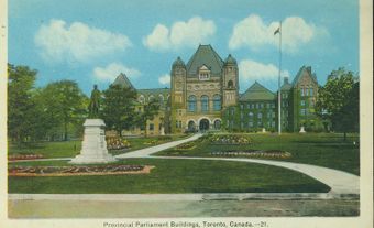
Provincial Government

There are 124 seats in Ontario’s provincial government. Each seat is held by a Member of Provincial Parliament (MPP) elected by eligible voters in their electoral district. According to the Elections Act, provincial elections are to be held on the first Thursday of June, every four years. Sometimes, should the party in power see it as advantageous, an election may be called before this date. Elections may also occur before four years have passed in cases where the government no longer has the confidence of the Legislative Assembly (see Minority Government).
As with the other provinces, Ontario uses a first past the post electoral system, meaning the candidate with the most votes in each electoral district wins. Typically, the party with the most seats forms the government, and the leader of this party becomes premier. However, a party with fewer seats may also form a coalition with members of another party or parties in order to form the government.
Technically, as the Queen’s representative, the lieutenant-governor holds the highest provincial office, though in reality this role is largely symbolic. (See also Ontario Premiers: Table; Ontario Lieutenant-Governors: Table.)
The premier typically appoints members of the Cabinet from among the MPPs also belonging to the party in power. Cabinet members are referred to as ministers and oversee specific portfolios. Typical portfolios include finance, health and education. (See also Politics in Ontario.)
Health
Most medical services in Canada are free. Money from taxes is pooled together to fund a health care system often referred to as medicare. While the federal government sets guidelines, each province and territory is responsible for administering its own health care insurance plan; funding for the plan comes from both governments. As with other provinces and territories, certain services in Ontario are not covered by the provincial health insurance plan. These include going to the dentist, prescription drugs and routine eye exams for those between the ages of 20 and 64.
In Ontario, the government department responsible for administering the health care system is the Ministry of Health and Long-Term Care. (See also Health Policy.)
Education
Ontario’s system of education is divided between two kinds of public schools: non-sectarian and “separate” or Roman Catholic. Within both of these systems are French-language school boards or French-language sections. Each system is run by boards elected by members of the public. This is the result of a compromise at the time of Confederation, when rights for Catholics in Ontario were traded off against those for Protestants in Québec.
Since 1899, Ontario has provided public funds to support education in Roman Catholic separate schools to the end of grade 10. In 1984, Premier Bill Davis startled Catholics and non-Catholics alike with a sudden announcement that his government would cover all the costs of separate school education in the remaining grades. This policy was implemented between 1985 and 1987.
Private schools are permitted to operate in accordance with the Education Act but do not receive any funding. Parents may also obtain permission from their local school board to educate their school-age children at home. On reserves, schools are run by the local First Nation and financially supported by the federal government. The federal government also operates six schools on reserves in Ontario, including five on the Six Nations reserve and one on Tyendinaga Mohawk territory (see also Education of Indigenous Peoples).
Although French-language schools existed in eastern and northern Ontario long before 1968, boards since then have been able to set up French schools “when numbers warrant” (see Separate School). In 1984, the Ontario Court of Appeal ruled that every francophone (and anglophone) student in the province has a right to education in his or her mother tongue. Linguistic minorities, the court also made clear, must be guaranteed representation on school boards and a say in minority-language instruction. The government immediately moved to comply with the court’s ruling, which was based on the Charter of Rights and Freedoms.
The education system is organized into elementary and secondary levels. Secondary students bound for university formerly completed a fifth year of high school, or grade 13. In 2003, Ontario’s grade 13 was eliminated.
In general, elementary schools provide programs for children from junior kindergarten to grade 8. As of September 1994, all school boards were required to make junior and senior kindergarten programs available. By 2015, full-day, optional kindergarten was available for all 4- and 5-year-olds attending English-language schools; this option had been available for over 10 years to those attending French-language schools.
Colleges and Universities
Ontario is home to a number of colleges and universities, including Canada’s two largest post-secondary institutions by student population (as of 2013), the University of Toronto and York University, as well as several other large campuses, including the University of Ottawa, Western University and the University of Waterloo. Other universities include the University of Windsor, Wilfred Laurier University in Waterloo, the University of Guelph, Brock University in St. Catharines, McMaster University in Hamilton, Ryerson and OCAD universities in Toronto, Trent University in Peterborough, Queen’s University and the Royal Military College in Kingston, and further north, Algoma, Lakehead, Laurentian and Nipissing universities, in Sault Ste. Marie, Thunder Bay, Sudbury and North Bay respectively.
There are also 24 community colleges in the province; three of the province’s largest are located in Toronto: Seneca, Humber and George Brown.
Transportation
Many municipalities in Ontario have public transit services, most of which include services operating on fixed routes and schedules for the general public and specialized door-to-door transit services for those with disabilities. The Toronto Transit Commission, or TTC, is the largest transit system in Ontario and the third-largest in North America (see also Toronto Subway). Metrolinx, an agency of the Ontario government, was created in 2006 to improve the co-ordination of transportation in the Greater Toronto and Hamilton areas. In 2009, Metrolinx merged with GO transit, a regional public transit service, and in 2011 introduced PRESTO, an electronic fare card with the goal of allowing passengers to transfer easily between different transit systems.
There are few roads in the North, and the most reliable form of transportation in this part of the province is still by air or water. VIA Rail offers passenger rail transportation to numerous cities and has major stations in Toronto, Ottawa, London, Kingston, Niagara Falls, Windsor, Sarnia and Sudbury. The Ontario Northland Transportation Commission, a provincial agency, provides train and bus services to northern communities.
Ontario has a large navigable water system, the St. Lawrence Seaway, along its southern frontier. The Welland Canal, an important part of the seaway channel, links Lakes Ontario and Erie. The advent of the seaway, and subsequently the practice of “containerization” of cargo unloaded at East Coast ports, have had a considerable negative impact on the structure of Ontario’s water transport. The most notable casualty has been the port of Toronto, where the number of tonnes shipped and the number of employed dropped drastically — Montréal, Saint John and Halifax being the beneficiaries. Two other Ontario ports, Hamilton and Thunder Bay, are ranked in Canada’s top 10 in the amount of cargo handled. Thunder Bay moves mainly coal, wheat and canola, while Hamilton handles iron ore, iron, steel, alloys and coal.
Toronto’s Lester B. Pearson International Airport is Canada’s largest and busiest airport. Other airports of note include Billy Bishop Toronto City Airport, the Ottawa Macdonald-Cartier International Airport and Hamilton’s John C. Munro International Airport.
Arts and Culture
Artistic and cultural endeavour in Ontario is encouraged through a variety of government subsidy programs, some federal and some provincial, such as the Ontario Arts Council (founded 1963), an independent government agency that gives grants to individuals and organizations.
There are symphony orchestras in Toronto (the Toronto Symphony Orchestra), Ottawa, Hamilton and Kitchener-Waterloo. A major Shakespearean festival called the Stratford Festival was founded in 1953 and is held each year in Stratford. Niagara-on-the-Lake’s annual Shaw Festival produces plays by Bernard Shaw or those from or about the era in which he lived. Major art galleries include the Art Gallery of Ontario, located in Toronto, and the National Gallery of Canada, located in Ottawa. Each fall, Toronto hosts the Toronto International Film Festival, the largest film festival in North America.
Sports
Ontario is home to two National Hockey League teams, the Toronto Maple Leafs and the Ottawa Senators, as well as Canada’s only Major League Baseball team, the Toronto Blue Jays, and only National Basketball Association team, the Toronto Raptors. The province’s three Canadian Football League teams are the Hamilton Tiger-Cats, Toronto Argonauts and Ottawa Redblacks. The Toronto FC is one of three Major League Soccer teams in Canada, and the Toronto Rock one of four National Lacrosse League teams.
Museums and Historic Sites

Major museums in Ontario include the Royal Ontario Museum, focusing on natural history and cultures from around the world, and the Aga Khan Museum, focusing on Muslim civilizations. Both are located in Toronto. As the nation’s capital, Ottawa is home to a number of important museums, including the Canadian Museum of Nature, the Canadian War Museum, the Canada Aviation and Space Museum, and the Canada Science and Technology Museum.
The mid-17th century Jesuit missions to the Wendat were among the first historic sites opened to the public. Having supported research in the area since 1890, the Ontario government undertook the reconstruction of Sainte-Marie Among the Hurons near Midland in 1964, and opened it to the public three years later.
Picturesque forts, the legacy of a long period of tension along the American-Canadian border dating from the beginning of the American Revolution, dot the southern reaches of the province. At Kingston, Fort Henry, whose stone walls were originally completed in the 1830s, is perhaps the best known, but Fort George and Fort Erie on the Niagara Historic Frontier, Fort Wellington (Prescott), Fort York (Toronto) and Fort Malden (Amhertsburg) have also been restored to their appearance at the time of the international crises and conflicts that marked the first part of the 19th century.
The life of the province’s pioneers is depicted in reconstructed townsites, including Upper Canada Village near Morrisburg and Black Creek Pioneer Village in northwest Toronto. In 1973, the Ontario government began to rebuild Fort William (at Thunder Bay), a fur-trading post established by the North West Companyin 1803. Boating enthusiasts enjoy two 19th-century canals — the Rideau Canal, built from 1826 to 1832 by the Royal Engineers for the movement of troops and military supplies, and the Trent, which dates back to 1833.