
Browse "Nature & Geography"
-
Article
Canadian Heritage Rivers System
Rivers are part of our lives and our heritage. They are the threads that bind the fabric of nature and humanity together.
"https://thecanadianencyclopedia.ca/images/tce_placeholder.jpg?v=e9dca980c9bdb3aa11e832e7ea94f5d9" // resources/views/front/categories/view.blade.php
https://thecanadianencyclopedia.ca/images/tce_placeholder.jpg?v=e9dca980c9bdb3aa11e832e7ea94f5d9
-
Article
Canadian Inuit Dog
The Canadian Inuit dog (Canis familiaris borealis) is one of five dog breeds recognized by the Canadian Kennel Club as uniquely Canadian (see also Dogs in Canada). While the Canadian Kennel Club refers to this breed as the “Canadian Eskimo dog,” the Government of Nunavut calls it the Canadian Inuit dog and made it the territory’s official animal. In the Eastern Baffin dialect of Inuktitut the dog is called qimmiq (spelled Kimmik in other dialects). For hundreds of years, these dogs were used by the Inuit and their ancestors to pull sleds as a means of transportation. From the 1950s to the 1970s, the Royal Canadian Mounted Police and other government officials killed thousands of sled dogs, rendering the breed extinct. Since then a revitalization program has helped re-establish the Canadian Inuit dog. As of 2018, there are approximately 300 Canadian Inuit dogs registered with the Canadian Kennel Club.
"https://d3d0lqu00lnqvz.cloudfront.net/media/new_article_images/CanadianInuitDog/8617902844_0c5f6c006f_c.jpg" // resources/views/front/categories/view.blade.php
https://d3d0lqu00lnqvz.cloudfront.net/media/new_article_images/CanadianInuitDog/8617902844_0c5f6c006f_c.jpg
-
Macleans
Canadians Split over Cost of Kyoto Accord
This article was originally published in Maclean’s magazine on March 18, 2002. Partner content is not updated.
"https://thecanadianencyclopedia.ca/images/tce_placeholder.jpg?v=e9dca980c9bdb3aa11e832e7ea94f5d9" // resources/views/front/categories/view.blade.php
https://thecanadianencyclopedia.ca/images/tce_placeholder.jpg?v=e9dca980c9bdb3aa11e832e7ea94f5d9
-
Article
Canals and Inland Waterways
These 2 great journeys were first made just before the end of the 18th century, and by the same man. Alexander Mackenzie reached the mouth of the river which now bears his name in 1789, and was the first European to cross the North American continent (to Bella Coola) in 1793.
"https://d3d0lqu00lnqvz.cloudfront.net/media/media/32cb8906-b09c-4152-b17f-79e56a5c8714.jpg" // resources/views/front/categories/view.blade.php
https://d3d0lqu00lnqvz.cloudfront.net/media/media/32cb8906-b09c-4152-b17f-79e56a5c8714.jpg
-
Article
Canola
Canola is a type of rapeseed and it is a Canadian innovation. Canola is characterized by having improved nutritional qualities in both its oil and meal. Canada produced 18.2 million tonnes of canola in 2022. The majority of canola produced in Canada is exported. The main importing markets are the United States, China, Japan, Mexico and the European Union. (See also Industry in Canada.)
"https://d3d0lqu00lnqvz.cloudfront.net/canola/canolabottle.jpg" // resources/views/front/categories/view.blade.php
https://d3d0lqu00lnqvz.cloudfront.net/canola/canolabottle.jpg
-
Article
Cape Bonavista
Cape Bonavista, elevation 15-30 m, is the bare, rocky extremity of the Bonavista Peninsula, north of the town of Bonavista in eastern Newfoundland.
"https://thecanadianencyclopedia.ca/images/tce_placeholder.jpg?v=e9dca980c9bdb3aa11e832e7ea94f5d9" // resources/views/front/categories/view.blade.php
https://thecanadianencyclopedia.ca/images/tce_placeholder.jpg?v=e9dca980c9bdb3aa11e832e7ea94f5d9
-
Article
Cape Bonavista Lighthouse
CAPE BONAVISTA separates Trinity and Bonavista bays on the eastern coast of Newfoundland. In 1842 it was decided to build a LIGHTHOUSE there as an aid to navigating the dangerous seas off the cape. The lighthouse operated for well over a century before it finally closed in 1962.
"https://thecanadianencyclopedia.ca/images/tce_placeholder.jpg?v=e9dca980c9bdb3aa11e832e7ea94f5d9" // resources/views/front/categories/view.blade.php
https://thecanadianencyclopedia.ca/images/tce_placeholder.jpg?v=e9dca980c9bdb3aa11e832e7ea94f5d9
-
Article
Cape Breton Island
Cape Breton Island, Nova Scotia, 10 311 km2, a rugged and irregularly shaped island, approximately 175 km long by 135 km at its widest, is located at the eastern extremity of the Gulf of St. Lawrence.
"https://d3d0lqu00lnqvz.cloudfront.net/media/media/36e542ee-68b2-4b59-8a62-795480916eae.jpg" // resources/views/front/categories/view.blade.php
https://d3d0lqu00lnqvz.cloudfront.net/media/media/36e542ee-68b2-4b59-8a62-795480916eae.jpg
-
Article
Cape Kildare
Cape Kildare extends eastward into the Gulf of St Lawrence at the northern end of Prince Edward Island. Named by Samuel Holland in 1765 after James, 20th earl of Kildare, it is part of a series of capes in the area known as the Kildare Capes.
"https://thecanadianencyclopedia.ca/images/tce_placeholder.jpg?v=e9dca980c9bdb3aa11e832e7ea94f5d9" // resources/views/front/categories/view.blade.php
https://thecanadianencyclopedia.ca/images/tce_placeholder.jpg?v=e9dca980c9bdb3aa11e832e7ea94f5d9
-
"https://thecanadianencyclopedia.ca/images/tce_placeholder.jpg?v=e9dca980c9bdb3aa11e832e7ea94f5d9" // resources/views/front/categories/view.blade.php
https://thecanadianencyclopedia.ca/images/tce_placeholder.jpg?v=e9dca980c9bdb3aa11e832e7ea94f5d9
-
Article
Cape Race
Cape Race, elevation 30-40 m, is the southeastern extremity of Newfoundland's AVALON PENINSULA. Named for its flat-topped (Portuguese, raso) cliffs, it has a barren appearance that creates a stark impression for transatlantic
"https://d3d0lqu00lnqvz.cloudfront.net/media/media/983b186a-56db-4168-af4e-574578d3bd37.jpg" // resources/views/front/categories/view.blade.php
https://d3d0lqu00lnqvz.cloudfront.net/media/media/983b186a-56db-4168-af4e-574578d3bd37.jpg
-
Article
Cape Sable
Cape Sable is the southernmost point of land on CAPE SABLE ISLAND, which lies off the southwestern tip of Nova Scotia. It is composed of shifting sand dunes (French, sable) up to 9 m high and is nearly joined to the island by a sandy beach transversed by Hawk Channel.
"https://thecanadianencyclopedia.ca/images/tce_placeholder.jpg?v=e9dca980c9bdb3aa11e832e7ea94f5d9" // resources/views/front/categories/view.blade.php
https://thecanadianencyclopedia.ca/images/tce_placeholder.jpg?v=e9dca980c9bdb3aa11e832e7ea94f5d9
-
Article
Cape Scott Provincial Park
Cape Scott Provincial Park (established 1973, 50 km2), on the northwest tip of VANCOUVER I, BC, includes 64 km of coast with 23 km of sandy beaches interspersed by rocky headlands. The land rises inland to Mount St Patrick (415 m), and in it lies a 44 ha body of freshwater, Eric Lake.
"https://thecanadianencyclopedia.ca/images/tce_placeholder.jpg?v=e9dca980c9bdb3aa11e832e7ea94f5d9" // resources/views/front/categories/view.blade.php
https://thecanadianencyclopedia.ca/images/tce_placeholder.jpg?v=e9dca980c9bdb3aa11e832e7ea94f5d9
-
Article
Cape Spear
Cape Spear, elev 75 m, most easterly point in N America (excluding Greenland), is located 6.7 km SE of the entrance to St John's harbour, Nfld. A rocky, windswept promontory of Precambrian formation, with a thin, sporadic cover
"https://d3d0lqu00lnqvz.cloudfront.net/media/media/907c73d8-6d3f-45cf-a339-1e12575cd24a.jpg" // resources/views/front/categories/view.blade.php
https://d3d0lqu00lnqvz.cloudfront.net/media/media/907c73d8-6d3f-45cf-a339-1e12575cd24a.jpg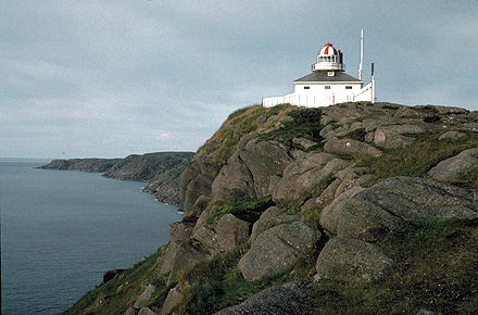
-
Article
Cape St Mary
Cape St Mary forms the southern boundary of St Mary's Bay in an area of Nova Scotia's northwestern coast known as the French Shore. Fishing is the principal activity in this region; the cape was once the site of the International Tuna Cup matches.
"https://thecanadianencyclopedia.ca/images/tce_placeholder.jpg?v=e9dca980c9bdb3aa11e832e7ea94f5d9" // resources/views/front/categories/view.blade.php
https://thecanadianencyclopedia.ca/images/tce_placeholder.jpg?v=e9dca980c9bdb3aa11e832e7ea94f5d9