
Browse "Places"
-
Article
Port-Royal National Historic Site
Located in Nova Scotia, Port-Royal National Historic Site features a reconstruction of the Port-Royal Habitation, one of the first settlements attempted by the French in North America (1605). Administered by Parks Canada, this historic site offers interpretive activities that convey the French settlers’ challenges in implementing the new colony. Visitors can also learn about the culture of the Mi’kmaq, the area’s first inhabitants of the land.
"https://d3d0lqu00lnqvz.cloudfront.net/media/media/64771090-5008-4ccf-9621-b6602042e7de.jpg" // resources/views/front/categories/view.blade.php
https://d3d0lqu00lnqvz.cloudfront.net/media/media/64771090-5008-4ccf-9621-b6602042e7de.jpg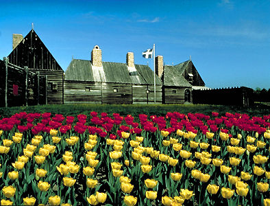
-
Article
Portage
Portage is a way by land around an interruption in a water route. Until the early 19th century most inhabitants of what is now Canada travelled mainly by water. Alexander Mackenzie and Simon Fraser demonstrated that it is possible, by portaging 100 times, to canoe from the St Lawrence to the Arctic or Pacific oceans.
"https://d3d0lqu00lnqvz.cloudfront.net/media/media/6a52818a-3f78-427a-a201-5e6bc9c5d874.jpg" // resources/views/front/categories/view.blade.php
https://d3d0lqu00lnqvz.cloudfront.net/media/media/6a52818a-3f78-427a-a201-5e6bc9c5d874.jpg
-
Article
Portage La Loche (Methye Portage)
Portage La Loche (Methye Portage), in present-day northern Saskatchewan, was the longest portage (20 km) in the regular fur trade, traversing the height of land between the Hudson Bay watershed and the Arctic watershed.
"https://thecanadianencyclopedia.ca/images/tce_placeholder.jpg?v=e9dca980c9bdb3aa11e832e7ea94f5d9" // resources/views/front/categories/view.blade.php
https://thecanadianencyclopedia.ca/images/tce_placeholder.jpg?v=e9dca980c9bdb3aa11e832e7ea94f5d9
-
Article
Portage la Prairie
Portage la Prairie, MB, incorporated as a city in 1907, population 13,270 (2021 census), 13,304 (2016 census). The city of Portage la Prairie, located 70 km west of Winnipeg, is an important regional service centre for the flat but highly fertile soils of the surrounding Portage Plains.
"https://d3d0lqu00lnqvz.cloudfront.net/media/media/7ab1a35a-234d-430c-8104-7c6abb2bd760.jpg" // resources/views/front/categories/view.blade.php
https://d3d0lqu00lnqvz.cloudfront.net/media/media/7ab1a35a-234d-430c-8104-7c6abb2bd760.jpg
-
Article
Portugal Cove-St Philip's
Portugal Cove-St Philip's, NL, incorporated as a town in 1992, population 7366 (2011c), 6575 (2006c). The Town of Portugal Cove-St Philip's is the result of the amalgamation of three former towns, Portugal Cove, St Philip's and Hogan's Pond, and the lands surrounding the communities.
"https://d3d0lqu00lnqvz.cloudfront.net/media/media/34e9289b-f9b0-47de-b85f-c55b822d3f93.jpg" // resources/views/front/categories/view.blade.php
https://d3d0lqu00lnqvz.cloudfront.net/media/media/34e9289b-f9b0-47de-b85f-c55b822d3f93.jpg
-
Article
Pouce Coupe
Pouce Coupe, British Columbia, incorporated as a village in 1932, population 792 (2016 census), 738 (2011 census). The village of Pouce Coupe is located 6 km southeast of Dawson Creek on the highway and freight railway between there and Grande Prairie, Alberta. Its name likely comes from that of a Dane-zaa chief, Pooscapee, which early voyageurs rendered into the French name Pouce Coupé (Cut Thumb).
"https://thecanadianencyclopedia.ca/images/tce_placeholder.jpg?v=e9dca980c9bdb3aa11e832e7ea94f5d9" // resources/views/front/categories/view.blade.php
https://thecanadianencyclopedia.ca/images/tce_placeholder.jpg?v=e9dca980c9bdb3aa11e832e7ea94f5d9
-
Article
Pouch Cove
Pouch Cove, NL, incorporated as a town in 1970, population 1866 (2011c), 1756 (2006c). The Town of Pouch Cove is located about 25 km north of ST JOHN'S near Cape St Francis.
"https://thecanadianencyclopedia.ca/images/tce_placeholder.jpg?v=e9dca980c9bdb3aa11e832e7ea94f5d9" // resources/views/front/categories/view.blade.php
https://thecanadianencyclopedia.ca/images/tce_placeholder.jpg?v=e9dca980c9bdb3aa11e832e7ea94f5d9
-
Article
Powell River
Powell River, BC, incorporated as a city in 2005, population 13,943 (2021 census), 13,157 (2016 census). The City of Powell River is located on the east side of the Strait of Georgia, 133 km northwest of Vancouver. It is bounded on the east by the Smith Mountain Range, Powell Lake and Haslam Lake. The city enjoys a mild climate year-round, moderated by the warm current of the strait. It takes its name from the river draining Powell Lake, which was named for Israel Wood Powell, British Columbia’s superintendent of Indian affairs in the 1880s.
"https://thecanadianencyclopedia.ca/images/tce_placeholder.jpg?v=e9dca980c9bdb3aa11e832e7ea94f5d9" // resources/views/front/categories/view.blade.php
https://thecanadianencyclopedia.ca/images/tce_placeholder.jpg?v=e9dca980c9bdb3aa11e832e7ea94f5d9
-
Article
Prairie
Prairies are a form of grassland reflecting the depositional features of the Wisconsinan glaciation. While often considered featureless flatlands, they actually contain great diversity. Topography ranges from broad undulating plains to rolling hills and plateaus, often dissected by beautiful valleys and escarpments.
"https://d3d0lqu00lnqvz.cloudfront.net/media/media/cff65572-5482-4d44-b068-c0b7b910cc49.jpg" // resources/views/front/categories/view.blade.php
https://d3d0lqu00lnqvz.cloudfront.net/media/media/cff65572-5482-4d44-b068-c0b7b910cc49.jpg
-
Article
History of Settlement in the Canadian Prairies
The Canadian Prairies were peopled in six great waves of migration, spanning from prehistory to the present. The migration from Asia, about 13,300 years ago, produced an Indigenous population of 20,000 to 50,000 by about 1640. Between 1640 and 1840, several thousand European and Canadian fur traders arrived, followed by several hundred British immigrants. They created dozens of small outposts and a settlement in the Red River Colony, where the Métis became the largest part of the population. The third wave, from the 1840s to the 1890s, consisted mainly but not solely of Canadians of British heritage. The fourth and by far the largest wave was drawn from many nations, mostly European. It occurred from 1897 to 1929, with a pause (1914–22) during and after the First World War. The fifth wave, drawn from other Canadian provinces and from Europe and elsewhere, commenced in the late 1940s. It lasted through the 1960s. The sixth wave, beginning in the 1970s, drew especially upon peoples of the southern hemisphere. It has continued, with fluctuations, to the present. Throughout the last century, the region has also steadily lost residents, as a result of migration to other parts of Canada, to the United States, and elsewhere.
"https://d3d0lqu00lnqvz.cloudfront.net/media/media/e1c671ab-3dcf-459c-b108-0bc6e4a86b99.jpg" // resources/views/front/categories/view.blade.php
https://d3d0lqu00lnqvz.cloudfront.net/media/media/e1c671ab-3dcf-459c-b108-0bc6e4a86b99.jpg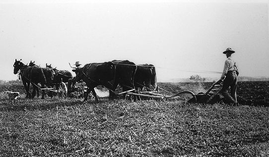
-
Article
Precious Blood Roman Catholic Church
The Église du Précieux Sang, built between 1967 and 1969 in St. Boniface, Manitoba, was designed by Étienne-Joseph Gaboury, of Gaboury, Lussier, Sigurdson Architects.
"https://thecanadianencyclopedia.ca/images/tce_placeholder.jpg?v=e9dca980c9bdb3aa11e832e7ea94f5d9" // resources/views/front/categories/view.blade.php
https://thecanadianencyclopedia.ca/images/tce_placeholder.jpg?v=e9dca980c9bdb3aa11e832e7ea94f5d9
-
Article
Première Nation des Pekuakamiulnuatsh
Première Nation des Pekuakamiulnuatsh is located in Quebec about 6 km north of Roberval on the western shore of Lac Saint-Jean. Prior to being declared a reserve as part of the Indian Act, the First Nation called their land Mashteuiatsh, which means “where there is a point.” Mashteuiatsh was a common meeting place due to its location along the banks of the Pekuakami. The primary languages of the First Nation are Nehlueun and French. Première...
"https://thecanadianencyclopedia.ca/images/tce_placeholder.jpg?v=e9dca980c9bdb3aa11e832e7ea94f5d9" // resources/views/front/categories/view.blade.php
https://thecanadianencyclopedia.ca/images/tce_placeholder.jpg?v=e9dca980c9bdb3aa11e832e7ea94f5d9
-
Article
Prescott
Prescott, Ontario, incorporated as a town in 1834, population 4,078 (2021 census), 4,222 (2016 census). The Town of Prescott is located 18 kilometres east of Brockville on the St Lawrence River.
"https://d3d0lqu00lnqvz.cloudfront.net/media/media/5dcffbb2-2b5e-41af-b0c3-752ed4cf7b9d.jpg" // resources/views/front/categories/view.blade.php
https://d3d0lqu00lnqvz.cloudfront.net/media/media/5dcffbb2-2b5e-41af-b0c3-752ed4cf7b9d.jpg
-
Article
Prince Albert
Prince Albert, SK, incorporated as a city in 1904, population 37,756 (2021 census), 35,926 (2016 census). The City of Prince Albert is located on the south shore of the North Saskatchewan River near the geographical centre of the province. As Saskatchewan's "Gateway to the North," open prairie lies to the south of the city and lakes and forests to the north. Prince Albert is Saskatchewan's third largest city.
"https://d3d0lqu00lnqvz.cloudfront.net/media/media/7a806eea-b539-4379-a058-0e45dabd0fe2.jpg" // resources/views/front/categories/view.blade.php
https://d3d0lqu00lnqvz.cloudfront.net/media/media/7a806eea-b539-4379-a058-0e45dabd0fe2.jpg
-
Article
Prince Albert National Park
Prince Albert National Park (est 1927, 3874.3 km2) is located 200 km north of Saskatoon. The cabin and grave of Grey Owl (Archibald Belaney) are located in the park beside Ajawaan Lake, where he spent the last 7 years of his life.
"https://d3d0lqu00lnqvz.cloudfront.net/media/media/f507b630-0ecd-47f8-b3a8-7ef49ed586c9.jpg" // resources/views/front/categories/view.blade.php
https://d3d0lqu00lnqvz.cloudfront.net/media/media/f507b630-0ecd-47f8-b3a8-7ef49ed586c9.jpg