
Browse "Geographical Features"
-
Article
Lac Mégantic (lake)
Lac Mégantic, 26 km2, elev 395 m, 75 m deep, is located in a depression of the Appalachians in southern Québec, 6 km from the US border. LAC-MÉGANTIC, the only town of the region, is located at its outlet, which is the source of the Rivière CHAUDIÈRE.
"https://thecanadianencyclopedia.ca/images/tce_placeholder.jpg?v=e9dca980c9bdb3aa11e832e7ea94f5d9" // resources/views/front/categories/view.blade.php
https://thecanadianencyclopedia.ca/images/tce_placeholder.jpg?v=e9dca980c9bdb3aa11e832e7ea94f5d9
-
Article
Lac Mistassini
Lac Mistassini, 2335 km2, elevation 372 m, max length 161 km and width 19 km, is located in central Québec, 360 km east of JAMES BAY and 220 km northwest of Lac SAINT-JEAN.
"https://thecanadianencyclopedia.ca/images/tce_placeholder.jpg?v=e9dca980c9bdb3aa11e832e7ea94f5d9" // resources/views/front/categories/view.blade.php
https://thecanadianencyclopedia.ca/images/tce_placeholder.jpg?v=e9dca980c9bdb3aa11e832e7ea94f5d9
-
Article
Lac Saint-Jean
Lac Saint-Jean, 1,003 km2, elevation 98 m, 63 m deep, is located in south-central Quebec, 206 km north of the St. Lawrence River, into which it flows via Saguenay River.
"https://d3d0lqu00lnqvz.cloudfront.net/13082433704_13129d1f88_k.jpg" // resources/views/front/categories/view.blade.php
https://d3d0lqu00lnqvz.cloudfront.net/13082433704_13129d1f88_k.jpg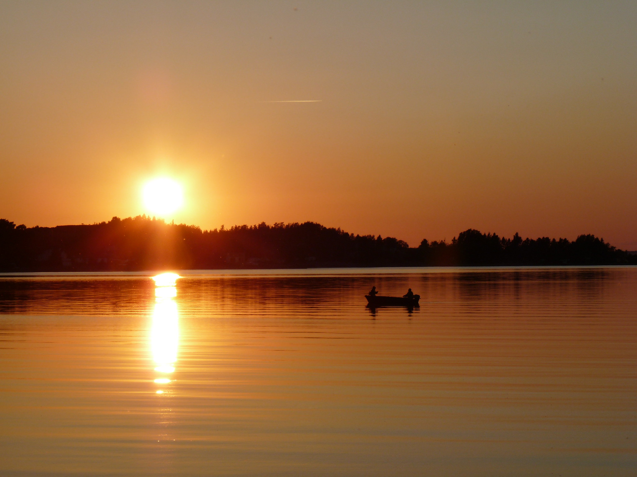
-
Article
Lac Seul
Lac Seul, 1658 km2, elev 357 m, 55 m deep, located in northwestern Ontario, 50 km N of Dryden, drains W via the English and Winnipeg rivers to Lk Winnipeg.
"https://thecanadianencyclopedia.ca/images/tce_placeholder.jpg?v=e9dca980c9bdb3aa11e832e7ea94f5d9" // resources/views/front/categories/view.blade.php
https://thecanadianencyclopedia.ca/images/tce_placeholder.jpg?v=e9dca980c9bdb3aa11e832e7ea94f5d9
-
Article
Lac Shawinigan
Shawinigan, Lac, 3.2 km2, 6.3 km long, 80 m deep, lies on Québec's Laurentian Plateau, 70 km north of Lac Saint-Pierre on the St Lawrence River. This lake of glacial gouging is prolonged to the east by Petit Lac Shawinigan, Lac Bernard and Lac en Croix.
"https://thecanadianencyclopedia.ca/images/tce_placeholder.jpg?v=e9dca980c9bdb3aa11e832e7ea94f5d9" // resources/views/front/categories/view.blade.php
https://thecanadianencyclopedia.ca/images/tce_placeholder.jpg?v=e9dca980c9bdb3aa11e832e7ea94f5d9
-
Article
LaHave River Estuary
LaHave River Estuary is a narrow, shallow inlet of the Atlantic Ocean extending 24 km from Bridgewater, NS, to the coast.
"https://thecanadianencyclopedia.ca/images/tce_placeholder.jpg?v=e9dca980c9bdb3aa11e832e7ea94f5d9" // resources/views/front/categories/view.blade.php
https://thecanadianencyclopedia.ca/images/tce_placeholder.jpg?v=e9dca980c9bdb3aa11e832e7ea94f5d9
-
Article
Lake Abitibi
Lake Abitibi, 932 km2, elev 265 m, straddles the Québec-Ontario border about 280 km south of James Bay.
"https://thecanadianencyclopedia.ca/images/tce_placeholder.jpg?v=e9dca980c9bdb3aa11e832e7ea94f5d9" // resources/views/front/categories/view.blade.php
https://thecanadianencyclopedia.ca/images/tce_placeholder.jpg?v=e9dca980c9bdb3aa11e832e7ea94f5d9
-
Article
Lake Agassiz
Formed 11,500 years ago, Lake Agassiz was the largest glacial lake in North America, at about 1,500 km long, over 1,100 km wide and 210 m deep. Its location covered parts of what is now Manitoba, Ontario, Saskatchewan, North Dakota and Minnesota.
"https://d3d0lqu00lnqvz.cloudfront.net/2091302531_8e5d16b234_k.jpg" // resources/views/front/categories/view.blade.php
https://d3d0lqu00lnqvz.cloudfront.net/2091302531_8e5d16b234_k.jpg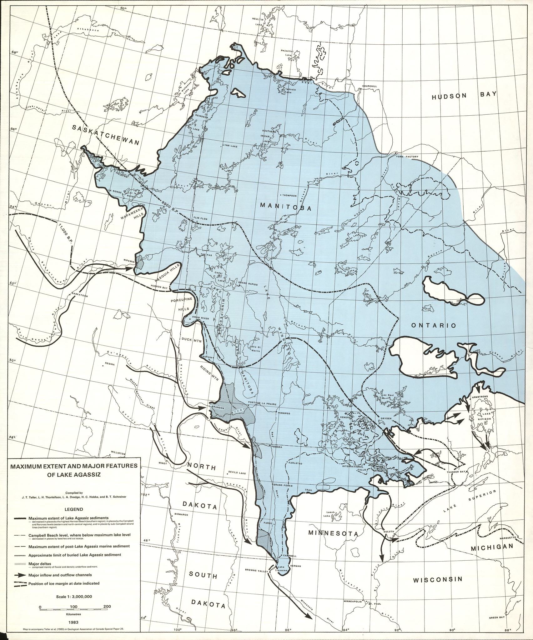
-
Article
Lake Athabasca
Lake Athabasca is located in northeastern Alberta and northwestern Saskatchewan, at the edge of the Precambrian Shield. With an area of 7,935 km2 and a 2,140 km shoreline, it is the eighth-largest lake in Canada.
"https://d3d0lqu00lnqvz.cloudfront.net/media/media/1c6f92bc-560d-45fe-a4b3-ee7504d34131.jpg" // resources/views/front/categories/view.blade.php
https://d3d0lqu00lnqvz.cloudfront.net/media/media/1c6f92bc-560d-45fe-a4b3-ee7504d34131.jpg
-
Article
Lake Diefenbaker
Lake Diefenbaker is a reservoir lake south of Saskatoon, Saskatchewan. It was formed by the construction of two dams that widened the South Saskatchewan River as part of the South Saskatchewan River Development Project, inaugurated in 1958.
"https://d3d0lqu00lnqvz.cloudfront.net/media/media/8f6aafbc-a6af-4161-aa3a-a8e615c2209b.jpg" // resources/views/front/categories/view.blade.php
https://d3d0lqu00lnqvz.cloudfront.net/media/media/8f6aafbc-a6af-4161-aa3a-a8e615c2209b.jpg
-
Article
Lake Huron
Lake Huron, 59,600 km2, elevation 176 m, 332 km long, 295 km wide, max depth 229 m; total shoreline length, including islands, 6,159 km. Lake Huron is the second largest of the Great Lakes and fifth-largest lake in the world (see also Largest Lakes in Canada). In Canada, the Lake Huron is part of the traditional territories of the Tionontati (Petun), Neutral, Huron-Wendat and Anishinaabe. Samuel de Champlain visited Georgian Bay and Lake Huron with the French scout Étienne Brûlé in 1615.
"https://d3d0lqu00lnqvz.cloudfront.net/media/media/d843f78b-9289-43dc-8791-10b06a322b23.jpg" // resources/views/front/categories/view.blade.php
https://d3d0lqu00lnqvz.cloudfront.net/media/media/d843f78b-9289-43dc-8791-10b06a322b23.jpg
-
Article
Lake Louise
Lake Louise, 2.4 km long, elevation 1731 m, is located in Banff National Park in southwestern Alberta. Lake Louise's outlet is a creek flowing into the Bow River.
"https://d3d0lqu00lnqvz.cloudfront.net/media/media/572e37ab-e754-4a3b-968d-a9a28711d955.jpg" // resources/views/front/categories/view.blade.php
https://d3d0lqu00lnqvz.cloudfront.net/media/media/572e37ab-e754-4a3b-968d-a9a28711d955.jpg
-
Article
Lake Manitoba
Lake Manitoba, 4624 km2, elev 248 m, is one of 3 large lakes occupying the southern half of Manitoba. A narrow, irregular lake, about 200 km long with marshy shores, it is fed mainly from Lake WINNIPEGOSIS, which lies to the northwest, and drains northeast via the Dauphin River to Lake WINNIPEG.
"https://thecanadianencyclopedia.ca/images/tce_placeholder.jpg?v=e9dca980c9bdb3aa11e832e7ea94f5d9" // resources/views/front/categories/view.blade.php
https://thecanadianencyclopedia.ca/images/tce_placeholder.jpg?v=e9dca980c9bdb3aa11e832e7ea94f5d9
-
Article
Lake Melville
Lake Melville 3069 km2, is a tidal extension of Hamilton Inlet on the rugged east coast of Labrador.
"https://thecanadianencyclopedia.ca/images/tce_placeholder.jpg?v=e9dca980c9bdb3aa11e832e7ea94f5d9" // resources/views/front/categories/view.blade.php
https://thecanadianencyclopedia.ca/images/tce_placeholder.jpg?v=e9dca980c9bdb3aa11e832e7ea94f5d9
-
Article
Lake Nipigon
Later posts were established by the NWC and HBC, but none grew into major settlements. With its limited population, unspoiled environment and abundant fish and wildlife, the area is ideal for outdoor recreation.
"https://thecanadianencyclopedia.ca/images/tce_placeholder.jpg?v=e9dca980c9bdb3aa11e832e7ea94f5d9" // resources/views/front/categories/view.blade.php
https://thecanadianencyclopedia.ca/images/tce_placeholder.jpg?v=e9dca980c9bdb3aa11e832e7ea94f5d9