Share on Facebook
 Share on X
 Share by Email
 Share on Google Classroom
Sparwood, British Columbia, incorporated as a district municipality in 1966, population 3,784 (2016 census), 3,667 (2011 census). The District of Sparwood is located 32 km northeast of Fernie in the Elk River Valley, and on the traditional territory of the Ktunaxa people.
Settlement and Development
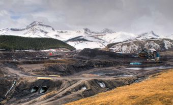
Sparwood dates back to the turn of the 20th century when local timber was considered “suitable for spars.” A spar is a pole used in shipbuilding, often as part of the mast. Also during this time, coal mining began in the area. Small mining communities developed in the Elk and Michel valleys. Sparwood was built for mine managers (1939). After the historic mining towns of Michel, Natal and Middletown were eliminated in the 1960s, Sparwood experienced rapid growth. It is now a centre for coal mining and processing, as well as for outdoor recreation.