Share on Facebook
 Share on X
 Share by Email
 Share on Google Classroom
British Columbia is divided by two of Canada’s seven physiographic regions. These regions are the Cordillera and the Interior Plains. The vast majority of the province is in the Cordillera region, while the northeast corner is part of the Interior Plains. Within the Cordillera region there are many mountain ranges, including the Rocky Mountains and the Coast Mountains. British Columbia’s wet, coastal climate is also home to some of the tallest coniferous trees in Canada, such as the Douglas fir.

Landscape and Population Distribution
Vancouver’s metropolitan area is home to over 50 per cent of the province’s population. Vancouver, and the communities that surround it, are British Columbia’s commercial, cultural and industrial centre. A slightly broader region, sometimes called the Georgia Strait region, includes Victoria and the southeast coast of Vancouver Island.
The vast interior of British Columbia is dominated by parallel mountain ranges. Its population spreads north–south along valleys, notably the Okanagan and the Kootenay. Population centres are dispersed. For example, Kamloops and Prince George are in the interior, Prince Rupert and Kitimat are on the northern coast, and Dawson Creek and Fort St. John are in the Peace River Lowland.
The northern half of the province is virtually uninhabited north of Prince Rupert. It is also cut off from the Pacific Ocean by the Alaska Panhandle.
The Peace River Lowland in the northeast is an extension of the Interior Plains physiographic region. It more closely resembles neighbouring Alberta than the rest of the province.
Landforms, Geology and Drainage
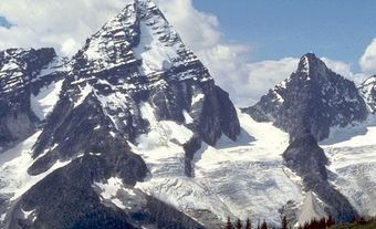
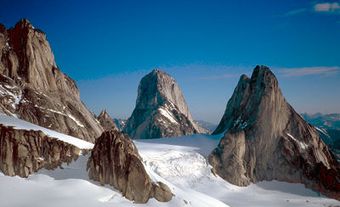
The Cordillera is part of a mountain system that extends the length of the western third of North and South America. The Cordillera mountain system covers most of British Columbia. It consists of two main mountain ranges. These ranges are the Coast Mountains in the west and the Rocky Mountains in the east. Other significant mountain ranges in British Columbia’s Cordillera region are the Columbia Mountains and the Cassiar-Omineca Mountains. Both ranges are west of the Rocky Mountains. The Columbia Mountains are in the province’s south-east corner while the Cassiar-Omineca Mountains are in the north.

The peaks in the southern portion of the Rocky Mountain range are sedimentary rock from the Paleozoic time period (541 to 251 million years ago). These peaks are different from the older ones in the northern portion of the Rocky Mountain range. The peaks in the northern portion are lower and more rounded. They are from the Proterozoic eon (2.5 billion to 541 million years ago). The western boundary of the Rocky Mountains is the Rocky Mountain Trench. The Rocky Mountain Trench is the longest valley in North America. It runs 1,400 km from Montana to the Yukon and along the length of British Columbia. Out of the trench flow the headwaters of the Kootenay, Columbia, Fraser, Parsnip, Finlay, Kechika and Liard rivers.
The Coast Mountains include granite rocks from the Cretaceous and Tertiary periods (145 to 2.58 million years ago). Numerous long, twisting, deep fjords penetrate into the Coast Mountains. The Insular Mountains are offshore, to the west of the Coast Mountains. They are the partially submerged northern continuation of the Olympic Mountains and Coast Ranges of Washington state. They provide the land mass for both Vancouver Island and Haida Gwaii.

The Interior Plateau covers central British Columbia. It is made up of broad and gently rolling uplands. The region is a basin or watershed, because it is surrounded by higher mountains. Many of the rocks are lavas from the Cretaceous and Tertiary periods. The Fraser River has cut deeply into the bedrock in the southern part of the plateau to form the Fraser River Canyon. The Stikine Plateau is to the north. It is another upland area of mainly Jurassic period lava rocks. This plateau contains the headwaters of the Stikine River. (See also Geological Regions.)
All of British Columbia was under a thick sheet of ice during the ice age. Some coastal areas and interior valleys became ice-free about 12,000–15,000 years ago. Since then the coastal lowlands have been rising relative to sea level. The remainder of the province became ice free 7,000–13,000 years ago. In the mountains, the results of glaciation can be seen in fjords and cirques (i.e. amphitheatre-shaped basins). In the Interior Plateau, the results of glaciation can be seen in ground moraines and terraces (i.e. flat areas above a river) and benches (i.e. flat, narrow platforms) along interior rivers.
Soils and Vegetation
Approximately 3 per cent of British Columbia has soil suitable for agriculture. Because British Columbia is mountainous, crops can only grow on floodplains, terraces and the deltas of river valleys. Glacial deposition on the middle slopes of the mountains provides enough soil to support tree growth.
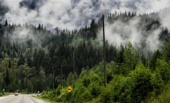
The coniferous trees of coastal British Columbia are the tallest and broadest trees in Canada. Douglas fir, western cedar, balsam fir, hemlock and Sitka spruce grow very well in the mild, wet climate. They are the basis for the province’s forestry industry. Similar trees, plus lodgepole pine, ponderosa pine and aspen, grow on the middle slopes of the interior mountains and plateaus. In contrast, the Coast Mountains and the lower river valleys across the southern third of the province have a drier climate. The drier climate creates grassland in these regions.
Climate

There are wide variations in climate within small areas of British Columbia. The major climate contrast is between the coast and the interior. Warm air masses from the Pacific Ocean mean mild coastal temperatures in the winter, while cold water keeps temperatures cool in the summer. The barrier of the Coast Mountains keeps these moderating conditions from moving inland. Average January mean temperatures are above 0°C at most coastal stations. These are the mildest January temperatures in Canada. In July, averages are about 15°C in the north and 18°C in the sheltered Georgia Strait region.
In contrast, in winter cold air masses from Yukon and Alaska push south into the interior of the province. Average daily mean January temperatures are -10°C to -15°C across the central interior. In the northeastern plains they are -20°C or more. In July, the southern interior valleys record average monthly temperatures of more than 20°C. Farther north, at higher altitudes on the central Interior Plateau, temperatures average about 15°C in midsummer.
Air masses from the Pacific Ocean bring ample rainfall to the coast. Autumn and winter are particularly rainy. The interior valleys on the eastern side of the mountains receive much less precipitation. The west-facing mountains of Vancouver Island receive more than 2,500 mm of annual precipitation. By comparison, the east-coast lowland records only about 700 to 1,000 mm. The western slopes of the Coast Mountains accumulate 1,000 to 3,000 mm annually. A large percentage of this precipitation is snowfall. However, the Okanagan Valley only receives 250 mm of annual precipitation.
Natural Resources

About 60 per cent of British Columbia is forested, accounting for approximately 19.5 per cent of the forested land in Canada. In addition, like most mountainous areas, there are many minerals in British Columbia. The mountainous part of the province is home to many metals, including lead, zinc, gold, silver, molybdenum, copper and iron. The Peace River Lowland, northeast of the Rocky Mountains, has a different geological base. It consists of younger, sedimentary rocks. These rocks are sources of petroleum, natural gas and coal.
British Columbia’s steep mountain slopes and large, interior drainage basins are ideal for the production of hydroelectric power. However, not all rivers in the province’s interior rivers are used for hydroelectricity. This is because the necessary infrastructure would damage the habitat of the Pacific salmon. Pacific salmon spawn in the headwaters of coastal and interior rivers.
Conservation
British Columbia’s economy relies heavily on renewable resources. Because of this, finding a balance between economic development and environmental protection is sometimes difficult. Early in its history, many of the province’s resources seemed inexhaustible. However, by the 1930s the coast forest was being rapidly depleted. The salmon fishery has been threatened by overfishing and the destruction of marine and river habitats. Similarly, some of British Columbia’s scarce agricultural land has been lost to roads, housing and industry. However, since the Second World War, much legislation has been enacted to preserve the environment and natural resources. For example, the British Columbia Ecological Reserves Act (1971) set aside numerous reserves of representative ecosystems. In addition, some of the country’s earliest National Parks were established in British Columbia. Glacier and Yoho were established in 1886, Mount Revelstoke in 1914 and Kootenay in 1920.