Share on Facebook
 Share on X
 Share by Email
 Share on Google Classroom
There are 30 reserves in Quebec, held by 25 of the province's 40 First Nations (see also First Nations in Quebec). In addition, there are 15 Inuit, 9 Cree and 1 Naskapi community whose lands fall under the jurisdiction of the James Bay and Northern Quebec Agreement and the Northeastern Quebec Agreement. Because they are not governed by the Indian Act, these communities are technically not reserves. There are also five First Nations in Quebec that do not have reserve lands (Long Point First Nation, Communauté anicinape de Kitcisakik, Wolf Lake First Nation, Montagnais de Pakua Shipi and Nation MicMac de Gespeg). This is the largest number of First Nations without reserve land of any province. Finally, the Mohawk Council of Akwesasne has a reserve that is partly in Quebec, Ontario and New York state. As of 2020, there were 92,762 registered Indians in Quebec, 64 per cent of whom live on reserve.
(map by The Canadian Encyclopedia, data courtesy Natural Resources Canada and licensed under Open Government Licence-Canada)
Demographics
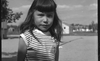
The First Nations who occupy Quebec are Abenaki, Algonquin, Atikamekw, Cree, Haudenosaunee, Huron-Wendat, Innu, Wolastoqiyik (Maliseet), Mi’kmaq and Naskapi. The reserve with the largest population belongs to the Mohawks of Kahnawà:ke. Of their 11,210 members in 2020, 7,967 lived on the reserve, which is located just outside Montreal.
Geography
When Quebec’s boundaries were drawn, it was without reference to the territorial boundaries of Indigenous nations. Because of this, most of the First Nations in Quebec have territory that extends into neighbouring provinces and states. For instance, the Cree occupy the lands around James Bay, on both sides of the Ontario-Quebec border. Similarly, the Algonquin occupy lands throughout the Ottawa River drainage, also on either side of the Ontario-Quebec border, and the Innu occupy lands in both Quebec and Labrador. This happens even at the community level. For example, the Mohawks of Akwesasne reserve lies in Ontario, Quebec and New York state.
Reserves are located throughout the province, in remote, rural and urban settings. Generally speaking, the Cree, Naskapi and Innu live in the more remote, northern areas of Quebec, while the Huron-Wendat and Haudenosaunee live in the south, near large urban centres. Some of the northern settlements, like the Cree community of Whapmagoostui, and the Naskapi at Kawawachikamach, are not accessible by road.

The province of Quebec measures 1,356,625 km2. As of 2020, 791.71 km2 of the province — 0.06 per cent — are reserve lands as defined by the Indian Act. Another 1,079,262 km2 fall under the James Bay and Northern Quebec Agreement and the Northeastern Quebec Agreement. First Nation and Inuit communities have complete control over 1.3 per cent of the area covered by these agreements (14,020 km2). In the remainder, rights to the land are shared between Indigenous people, non-Indigenous people and the province.
History
Land Purchases and Grants
The first reserves in Quebec were purchased by individuals or granted by the French government. They were given to religious orders associated with the Roman Catholic Church. The reserves were intended to be places where First Nation peoples could be centralized, converted to Catholicism and “civilized.” The first reserve of this type was also the first reserve in what is now Canada. It was established at Sillery, near Quebec City, in 1637. It was a social and economic failure, and was abandoned by the late 1680s.
The Seigneury of Sault St. Louis, near Montreal, was granted to the Jesuits by the French in 1680. It was meant to benefit the Haudenosaunee and other tribes. Originally, it measured about 182 km2, but the Jesuits began selling off parcels to settlers. This led to complaints from the Haudenosaunee. These disputes continue today. Currently, what remains of the Seigneury of Sault St. Louis is legally known as Kahnawake Indian Reserve No. 14, and is held by the Mohawks of Kahnawà:ke. The reserve measures just over 49 km2.
Royal Proclamation of 1763
In 1763, at the end of the Seven Years’ War, France surrendered its northern North American colonies to the British. The Royal Proclamation of 1763 established procedures for treaty-making and the sale of Indigenous territory to Britain. It also established the boundaries of the colony of Quebec. At the time, Quebec was essentially a strip of land along the St. Lawrence River, extending up the Ottawa River to Lake Nipissing. Lands to the west and north of the colony were declared Indian territory. They were reserved for the exclusive use of the Indigenous nations who occupied them. In addition, land within the colony that had not yet been settled by Europeans was subject to the treaty-making provisions laid out in the Royal Proclamation.

In the years following 1763, Britain (and later Canada) used the Royal Proclamation to guide treaty- and reserve-making in what is now Ontario and the Prairies. For a variety of reasons this did not happen in Quebec (then known as Lower Canada). One of the problems was that the British Imperial government was responsible for treaty-making, while the local colonial government was under pressure to open up lands for settlement and logging. Most often, settler interests were favoured over those of Indigenous peoples. As time passed and Lower Canada’s boundaries were enlarged, no treaties were made with Indigenous nations. Instead, their territories were taken away from them and their economic systems and social organizations were disrupted.
Between 1760 and 1860, a number of ordinances and laws were adopted to prevent trespass and encroachment on Indigenous reserves and villages in Lower Canada. Reserves continued to be established; however, the trespass laws were not enforced. Some of today’s reserves, such as Listigujj, were established during this period.
Legislation in 1850 and 1851
Circumstances became increasingly difficult for First Nations in Quebec in the 1830s and 1840s. Settlement was expanding in the province, then known as Lower Canada or Canada East. Existing reserves were being encroached upon, and communities in more remote locations were beginning to feel pressure from loggers and fishermen. Indigenous communities across Lower Canada began petitioning the government. In 1847, for example, the Innu of the north shore of the St. Lawrence River sent a letter to the colonial government. Part of it read:
The Province has collected revenue from our territory for a long time, through rents to the treaty posts and logging, equally; and whereas our hunting grounds are diminishing in size, by turning them over to farming, we have received no compensation as yet.
And so here we are, back in the woods. Soon we won’t even have a river in which to lay our nets. We will disappear like dust in the wind if you do not protect us.
By petitioning the government, other First Nations sought similar solutions. They wanted their land rights respected, existing reserves protected, and new reserves set aside for their exclusive use. The government responded to this pressure by passing legislation in 1850 and 1851. The 1850 legislation was called "An Act for the better protection of the Lands and Property of the Indians in Lower Canada." It was intended to better protect reserves from trespass and defend First Nations property rights. The 1851 legislation was called "An Act to authorize the setting apart of Lands for the use of certain Indian Tribes in Lower Canada." It provided for the setting aside of new reserves in Lower Canada.

On the whole, implementation of the 1850 and 1851 legislation was haphazard and non-committal. The amount of land set aside for new reserves was capped at 230,000 acres. In addition, there were long delays in surveying land for reserves. In many cases, squatters and loggers had already taken up possession of the lands that were supposed to be protected for First Nations. For example, by 1852 squatters occupied part of the lands to be set aside at Listuguj for the Mi’kmaq. The squatters successfully petitioned for these boundaries to be changed. And at River Desert, timber licences already covered the lands selected for an Algonquin reserve.
Post-Confederation
When Canada became a country in 1867, the British North America Act said the new federal government would be responsible for “Indians and lands reserved for Indians.” In turn, the provinces gained control over the lands and resources within their boundaries. Following this, Quebec took an increasingly hard line against the creation of reserves, including those that should have resulted from the 1851 legislation. Quebec was resistant in part because it viewed Indigenous peoples’ rights, and their possession of land, as a threat to business and settler interests. But Quebec also did not like increased federal authority within the province. Since Indigenous peoples and their lands fell under a federal area of jurisdiction, Quebec was now even more reluctant to create or protect reserves.
However, in the late 19th and early 20th centuries, there was one thing that Canada and Quebec both agreed on: that Indigenous peoples should be assimilated. They also agreed that reserve lands should be reduced, broken up, surrendered and sold off. The province and the federal government cooperated to secure the reduction and surrender of Indian reserves in Quebec wherever possible. The Algonquin reserve at Timiskaming provides a stark example. Measuring upwards of 75,000 acres when it was first surveyed in 1854, the Timiskaming reserve was reduced to 38,400 acres during a re-survey in 1895. Within three years of this re-survey, surrenders were secured for 60 per cent of the reserve, or over 23,000 acres. Over the next 39 years, another 10,500 were taken, leaving the community with only about 5,000 acres today.
By 1921, almost the entire 230,000 acres of reserve lands specified in the 1851 legislation had been allocated. However, much of this land had been subsequently surrendered. As a result, the actual amount of reserve land was a lot less. In 1922, Quebec adopted legislation governing the setting aside of new reserves in the province. The legislation was called "An Act Respecting Lands set apart for Indians." It set a new cap of 330,000 acres for reserve lands. However, the province continued to delay creating new reserves, despite continuing petitions from across the province. Communities faced increasing hardship as the federal government required that housing, healthcare and educational services be delivered on reserve.

It was not until 1944 that the first reserve following the 1922 legislation was created; it was the reserve set aside for the Atikamekw First Nation at Obedjiwan. However, Quebec continued to resist working with the federal government in order to create reserves. In certain cases, the federal government purchased land from third parties in order to get around Quebec’s resistance. The reserves held by the Abitibiwinni and Kebaowek First Nations were established this way.
In 1982, Quebec adopted a policy on the creation of new reserves and expansion of existing reserves. It remains very restrictive, and only permits the existence of reserves used exclusively for residential purposes (i.e., not for economic development or traditional harvesting).
Politics
Reserves in Quebec, like in other provinces, are governed by chiefs and councils. The size of the government and the length of their time in office differs from First Nation to First Nation. Some are governed according to the Indian Act, which provides one chief as well as one councillor for every 100 members of the First Nation. The chief and councillors are elected every two years.
The majority of First Nations in Quebec use what the federal government calls a “custom” form of governance. This means that the First Nation has more choice as to what their leadership selection process looks like. Under custom systems, chiefs and councils are often elected for longer terms. For example, Wolf Lake First Nation elects a chief and two councillors over a four-year cycle.
Similarly, the First Nations Elections Act also allows for longer terms. Introduced in 2014, the Act does not replace the Indian Act or custom governance systems. Instead, it allows bands to opt into a modified form of theIndian Act’selectoral system. As of 2020, one Quebec First Nation, the Micmacs of Gesgapegiag, has adopted this form of governance. Finally, Cree and Naskapi First Nations, whose land is included in the James Bay and Northern Quebec Agreement and the Northeastern Quebec Agreement, have local administrations established under the Cree-Naskapi (of Quebec) Act of 1984. The Assembly of First Nations Quebec-Labrador represents the region at a national level.

In the late 1800s and through the 1900s, the federal government interfered with the internal affairs of First Nations. For example, they removed chiefs and imposed electoral processes. These efforts caused significant damage to many communities. Recently, the federal government has been more accepting of First Nations forms of governance. In addition, many communities have taken significant steps to renew and restore their traditional systems of government, at the local level as well as at the level of Nation.
Arts and Culture

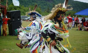
There are a number of notable artists and athletes who hail from First Nations in Quebec. Florent Vollant, one member of the Innu musical ensemble Kashtin, is from Maliotenam, a reserve near Sept-Iles. Kashtin was one of the first acts to bring Indigenous music and language into the mainstream. The award winning Abenaki filmaker and writer Alanis Obomsawin grew up in Odanak, a reserve next to Pierreville. Waneek Horn-Miller is a noted athlete from Kahnawake. She won gold at the 1999 Pan American Games in Winnipeg, and was co-captain of the first Canadian women’s Olympic water polo team. Kahnawake hosts the annual Echoes of a Proud Nation Pow-Wow every July (see Powwows in Canada). Each August, residents of Maliotenam host the Innu Nikamu (the Singing Man) festival.