Browse "Places"
-
Article
Jacob Bell Barron
Jacob Bell (J.B.) Barron, lawyer, theatre impresario and owner, real estate developer (born 1 January 1888 in Winnipeg, MB; died 27 September 1965 in Calgary, AB). J.B. Barron was one of the earliest Jewish lawyers to be admitted to the bar in Calgary. He was also a key figure in the arts and cultural evolution of the city as the owner of theatres and theatre impresario. He is credited by sources as the developer of one of Calgary’s earliest and largest mixed-use, high-rise towers, which was built in response to the discovery of oil in 1947 near Leduc, Alberta. (See also Striking Oil in Leduc: the Beginning of Alberta’s Oil Boom.)
"https://d3d0lqu00lnqvz.cloudfront.net/jbbarron/Barronjhsa.jpg" // resources/views/front/categories/view.blade.php
https://d3d0lqu00lnqvz.cloudfront.net/jbbarron/Barronjhsa.jpg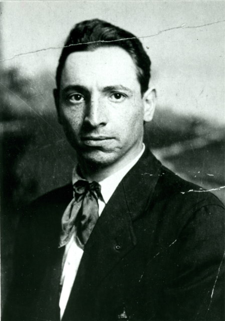
-
Article
Jaffray Melick
Jaffray Melick, Ont, was a town from 1988 to 2000. Its former territory is now the easternmost section of the city of KENORA.
"https://d3d0lqu00lnqvz.cloudfront.net/media/media/1bf03a7f-ee0f-4f62-bd82-e4196d3f3040.jpg" // resources/views/front/categories/view.blade.php
https://d3d0lqu00lnqvz.cloudfront.net/media/media/1bf03a7f-ee0f-4f62-bd82-e4196d3f3040.jpg
-
Article
James Bay
James Bay is the southern appendage of Hudson Bay. It is about 160 km wide between Pointe-à-Louis-XIV on the east coast and Cape Henrietta Marie on the west. The Quebec-Ontario border is at the bottom of the bay, and its numerous islands were administered by the Northwest Territories but are now part of the territory of Nunavut. Akimiski is the largest island with an area of 3,001 km2.
"https://d3d0lqu00lnqvz.cloudfront.net/jamesbay/Canadian_Shield_James_Bay_04.jpg" // resources/views/front/categories/view.blade.php
https://d3d0lqu00lnqvz.cloudfront.net/jamesbay/Canadian_Shield_James_Bay_04.jpg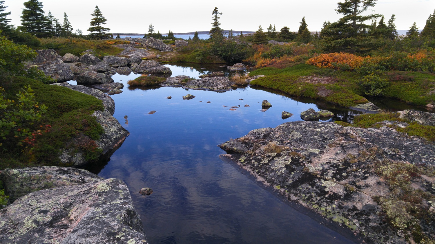
-
Article
Jami Mosque
Jami Mosque is the Greater Toronto Area’s oldest mosque, though it is not the first one. Located at 56 Boustead Ave, Jami Mosque is called “the mother of all mosques in Toronto.” As a mosque, it has housed hundreds of Muslims for prayer. As an Islamic centre, it provides education on Islamic rituals, histories and values.
"https://d3d0lqu00lnqvz.cloudfront.net/Jami_Mosque_Entrance.jpg" // resources/views/front/categories/view.blade.php
https://d3d0lqu00lnqvz.cloudfront.net/Jami_Mosque_Entrance.jpg
-
Article
Jasper
Jasper, Alta, incorporated as a specialized municipality in 2001, population 4051 (2011c), 4265 (2006c). The Municipality of Jasper is located at the junction of the Miette and Athabasca rivers in JASPER NATIONAL PARK, 362 km west of Edmonton.
"https://d3d0lqu00lnqvz.cloudfront.net/media/media/c315e3ee-1e50-4979-8262-d18cb2844c6e.jpg" // resources/views/front/categories/view.blade.php
https://d3d0lqu00lnqvz.cloudfront.net/media/media/c315e3ee-1e50-4979-8262-d18cb2844c6e.jpg
-
Article
Jasper National Park
Jasper National Park is a protected area located in the Rocky Mountains, about 370 km west of Edmonton, Alberta. Established in 1907, it was the fifth national park created in Canada. It’s also one of seven parks in the Rocky Mountains that make up the Canadian Rocky Mountain Parks UNESCO World Heritage site (the others are Yoho, Banff and Kootenay national parks, and Mount Robson, Mount Assiniboine and Hamber provincial parks). Among the reasons for the UNESCO designation are the parks’ mountain landscapes, complete with waterfalls, canyons and glaciers, including those found in the Columbia Icefield.
"https://d3d0lqu00lnqvz.cloudfront.net/media/Twitter_Cards/jasper.jpg" // resources/views/front/categories/view.blade.php
https://d3d0lqu00lnqvz.cloudfront.net/media/Twitter_Cards/jasper.jpg
-
Article
Jazz City
Jazz City (formally, Jazz City International Jazz Festival 1980-90, du Maurier Ltd Jazz City, as of 1991). It was established by the Edmonton Jazz Society in 1980 under the direction of Marc Vasey in response to an initiative from Alberta Culture on the occasion of the province's 75th anniversary.
"https://thecanadianencyclopedia.ca/images/tce_placeholder.jpg?v=e9dca980c9bdb3aa11e832e7ea94f5d9" // resources/views/front/categories/view.blade.php
https://thecanadianencyclopedia.ca/images/tce_placeholder.jpg?v=e9dca980c9bdb3aa11e832e7ea94f5d9
-
Article
Jemseg Archaeological Site
The Jemseg archaeological site (Borden site designation number BkDm-14) is a major archaeological site located in south-central New Brunswick, on the stream that connects the Grand Lake system to the lower Saint John River.
"https://d3d0lqu00lnqvz.cloudfront.net/media/media/a7ddfad9-aa2e-425b-b65a-3fbd6a372095.jpg" // resources/views/front/categories/view.blade.php
https://d3d0lqu00lnqvz.cloudfront.net/media/media/a7ddfad9-aa2e-425b-b65a-3fbd6a372095.jpg
-
Article
Joggins Fossil Cliffs
The Joggins Fossil Cliffs are located in Nova Scotia, on the shores of Cumberland Basin in the upper Bay of Fundy. They contain an exceptional fossil record of the carboniferous period. In 2008, these cliffs were designated a UNESCO World Heritage Site.
"https://thecanadianencyclopedia.ca/images/tce_placeholder.jpg?v=e9dca980c9bdb3aa11e832e7ea94f5d9" // resources/views/front/categories/view.blade.php
https://thecanadianencyclopedia.ca/images/tce_placeholder.jpg?v=e9dca980c9bdb3aa11e832e7ea94f5d9
-
Article
Joliette
Joliette, Quebec, incorporated as a town in 1863, as a city in 1918, population 21,384 (2021 census), 20,484 (2016 census). Joliette is located approximately 60 km northeast of Montreal on the banks of the Rivière l'Assomption, close to the Laurentians and surrounded by a prosperous agricultural region.
"https://thecanadianencyclopedia.ca/images/tce_placeholder.jpg?v=e9dca980c9bdb3aa11e832e7ea94f5d9" // resources/views/front/categories/view.blade.php
https://thecanadianencyclopedia.ca/images/tce_placeholder.jpg?v=e9dca980c9bdb3aa11e832e7ea94f5d9
-
Article
Music in Joliette
City situated 75 kilometres to the north-east of Montreal, incorporated on 18 October 1863. In 1991, Joliette had a population of about 31,000 inhabitants.
"https://thecanadianencyclopedia.ca/images/tce_placeholder.jpg?v=e9dca980c9bdb3aa11e832e7ea94f5d9" // resources/views/front/categories/view.blade.php
https://thecanadianencyclopedia.ca/images/tce_placeholder.jpg?v=e9dca980c9bdb3aa11e832e7ea94f5d9
-
Article
Jonquière
As the industrial axis of the region, its history is closely tied to the history of major corporations, specifically to that of the Price Company Ltd (now Abitibi-Price Inc) and Alcan. An agricultural parish founded in 1847, Jonquière began developing after 1893 when the railway arrived.
"https://d3d0lqu00lnqvz.cloudfront.net/media/media/21c5573a-de65-429a-b557-c72d0572f3dc.jpg" // resources/views/front/categories/view.blade.php
https://d3d0lqu00lnqvz.cloudfront.net/media/media/21c5573a-de65-429a-b557-c72d0572f3dc.jpg
-
Article
Juan de Fuca Strait
Juan de Fuca Strait is an inlet of the Pacific Ocean between Vancouver Island and Washington State, connecting the Strait of Georgia and Puget Sound to the outer ocean.
"https://thecanadianencyclopedia.ca/images/tce_placeholder.jpg?v=e9dca980c9bdb3aa11e832e7ea94f5d9" // resources/views/front/categories/view.blade.php
https://thecanadianencyclopedia.ca/images/tce_placeholder.jpg?v=e9dca980c9bdb3aa11e832e7ea94f5d9
-
Article
Jumbo Pass
Jumbo Pass, elevation 2,270 m, is situated in the central Purcell Mountains of British Columbia.
"https://thecanadianencyclopedia.ca/images/tce_placeholder.jpg?v=e9dca980c9bdb3aa11e832e7ea94f5d9" // resources/views/front/categories/view.blade.php
https://thecanadianencyclopedia.ca/images/tce_placeholder.jpg?v=e9dca980c9bdb3aa11e832e7ea94f5d9
-
Article
Canada on D-Day: Juno Beach
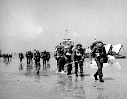
Juno Beach was the Allied code name for a 10 km stretch of French coastline assaulted by Canadian soldiers on D-Day, 6 June 1944, during the Second World War. The Canadian Army’s 3rd Infantry Division and 2nd Armoured Brigade seized the beach and its seaside villages while under intense fire from German defenders — an extraordinary example of military skill, reinforced by countless acts of personal courage. The 3rd Infantry Division took heavy casualties in its first wave of attack but took control of the beach by the end of the day. More than 14,000 Canadian soldiers landed or parachuted into France on D-Day. The Royal Canadian Navy contributed 110 warships and 10,000 sailors and the RCAF contributed 15 fighter and fighter-bomber squadrons to the assault. There were 1,074 Canadian casualties, including 359 killed.
"https://d3d0lqu00lnqvz.cloudfront.net/media/media/f6f8902f-029b-4666-8ab3-5ccd0711dda3.jpg" // resources/views/front/categories/view.blade.php
https://d3d0lqu00lnqvz.cloudfront.net/media/media/f6f8902f-029b-4666-8ab3-5ccd0711dda3.jpg