Browse "Cities & Populated Places"
-
Article
New Maryland
New Maryland includes a number of historic buildings, including the Anglican church and Victoria Hall. It was the site of the last fatal duel in the province in 1821.
"https://d3d0lqu00lnqvz.cloudfront.net/media/media/d2d9fbdd-77c8-46bf-80c4-6ebaf8dab8e0.jpg" // resources/views/front/categories/view.blade.php
https://d3d0lqu00lnqvz.cloudfront.net/media/media/d2d9fbdd-77c8-46bf-80c4-6ebaf8dab8e0.jpg
-
Article
New Richmond
Although New Richmond is today about 80% French-speaking, its history is steeped in cultural diversity.
"https://d3d0lqu00lnqvz.cloudfront.net/media/media/9616645e-ad72-48e7-9556-6507df6a0e92.jpg" // resources/views/front/categories/view.blade.php
https://d3d0lqu00lnqvz.cloudfront.net/media/media/9616645e-ad72-48e7-9556-6507df6a0e92.jpg
-
Article
New Tecumseth
New Tecumseth, Ont, incorporated as a town in 1991, population 30 234 (2011c), 27 701 (2006c).
"https://thecanadianencyclopedia.ca/images/tce_placeholder.jpg?v=e9dca980c9bdb3aa11e832e7ea94f5d9" // resources/views/front/categories/view.blade.php
https://thecanadianencyclopedia.ca/images/tce_placeholder.jpg?v=e9dca980c9bdb3aa11e832e7ea94f5d9
-
Article
New-Wes-Valley
New-Wes-Valley, NL, incorporated as a town in 1992, population 2265 (2011c), 2485 (2006c). The Town of New-Wes-Valley is located on the northern coast of BONAVISTA BAY.
"https://thecanadianencyclopedia.ca/images/tce_placeholder.jpg?v=e9dca980c9bdb3aa11e832e7ea94f5d9" // resources/views/front/categories/view.blade.php
https://thecanadianencyclopedia.ca/images/tce_placeholder.jpg?v=e9dca980c9bdb3aa11e832e7ea94f5d9
-
Article
New Westminster
New Westminster, British Columbia, incorporated as a city in 1860, population 78,916 (2021 census), 70,996 (2016 census). The city of New Westminster is located on the north bank of the Fraser River, 20 km east of Vancouver. Governor James Douglas established New Westminster in 1859 as the capital of British Columbia. The Royal Engineers surveyed the city and Queen Victoria named it. As a result, New Westminster’s nickname is “The Royal City.” New Westminster is western Canada’s oldest city.
"https://d3d0lqu00lnqvz.cloudfront.net/media/media/8405cd89-59b7-4b0f-b434-ec1d2f55f2c1.jpg" // resources/views/front/categories/view.blade.php
https://d3d0lqu00lnqvz.cloudfront.net/media/media/8405cd89-59b7-4b0f-b434-ec1d2f55f2c1.jpg
-
Article
Newfoundland and Labrador and Confederation
Attempts to bring Newfoundland into Confederation in the 1860s and 1890s were met with lukewarm interest in the colony. In 1934, Newfoundland was in bankruptcy during the Great Depression. It suspended responsible government and accepted an unelected Commission Government directed by Britain. In a 1948 referendum, Newfoundlanders were given the choice to either continue with the Commission Government, join Canada, or seek a return to responsible government as an independent dominion. The independence option won the first vote. But the Confederation option won a run-off vote with 52.3 percent support. The British and Canadian parliaments approved of the union. Newfoundland became Canada’s 10th province on 31 March 1949. In 2001, the province’s name was officially changed to Newfoundland and Labrador.
"https://d3d0lqu00lnqvz.cloudfront.net/TCEImages/f6d1eaf9-8a3d-4e63-b541-3f932d9b4746.jpg" // resources/views/front/categories/view.blade.php
https://d3d0lqu00lnqvz.cloudfront.net/TCEImages/f6d1eaf9-8a3d-4e63-b541-3f932d9b4746.jpg
-
Editorial
Editorial: How the “Canadianized” Community of Newfoundland Joined Canada
The following article is an editorial written by The Canadian Encyclopedia staff. Editorials are not usually updated. When the Parliament Buildings in Ottawa were repaired after a fire during the First World War, stone plaques were erected over the entrance to the Peace Tower. There were ten of them — nine bearing the coats of arms of the provinces and one left bare, to await the day when Newfoundland joined Canada.
"https://thecanadianencyclopedia.ca/images/tce_placeholder.jpg?v=e9dca980c9bdb3aa11e832e7ea94f5d9" // resources/views/front/categories/view.blade.php
https://thecanadianencyclopedia.ca/images/tce_placeholder.jpg?v=e9dca980c9bdb3aa11e832e7ea94f5d9
-
Article
Newmarket
Newmarket, Ontario, incorporated as a town in 1880, population 87,942 (2021 census), 84,224 (2016 census). Newmarket’s modern boundaries were created in 1971 from the town itself, and portions of the townships of King, East Gwillimbury, and Whitchurch (see Whitchurch-Stouffiville). Located within York Region, Newmarket is in the Toronto Census Metropolitan Area. Throughout history, the Newmarket area has been home to different Indigenous groups, namely the Wendat (Huron), Tionontati (Petun), Haudenosaunee and the Anishinaabeg. The land is covered by Treaty 13 and the Williams Treaties.
"https://d3d0lqu00lnqvz.cloudfront.net/media/media/2143d913-8b18-4c06-8a1f-f540e3d5df7d.jpg" // resources/views/front/categories/view.blade.php
https://d3d0lqu00lnqvz.cloudfront.net/media/media/2143d913-8b18-4c06-8a1f-f540e3d5df7d.jpg
-
Article
Niagara-on-the-Lake
Niagara-on-the-Lake, Ontario, incorporated as a town in 1792 and reincorporated in 1970, population 19,088 (2021 census), 17,511 (2016 census). The town of Niagara-on-the-Lake is located where the Niagara River enters Lake Ontario. In 1970, the old town of Niagara-on-the-Lake joined the Township of Niagara. The township included the villages of Virgil, Queenston, St. Davids, Homer and McNab. Together they became a regional town retaining the name Niagara-on-the-Lake.
"https://d3d0lqu00lnqvz.cloudfront.net/media/media/ea2f6b4b-d499-42a2-b95f-3ee49922b58b.jpg" // resources/views/front/categories/view.blade.php
https://d3d0lqu00lnqvz.cloudfront.net/media/media/ea2f6b4b-d499-42a2-b95f-3ee49922b58b.jpg
-
Article
Nicolet
In the early 19th century it became a major agricultural town and an important crossroads for the townships of the S shore. With its economic activity based on the forest and dairy industries and retail commerce, Nicolet was increasingly the centre for back-country agricultural parishes.
"https://thecanadianencyclopedia.ca/images/tce_placeholder.jpg?v=e9dca980c9bdb3aa11e832e7ea94f5d9" // resources/views/front/categories/view.blade.php
https://thecanadianencyclopedia.ca/images/tce_placeholder.jpg?v=e9dca980c9bdb3aa11e832e7ea94f5d9
-
Article
Nipawin
Nipawin is situated at a point on the Saskatchewan River where the prairie and woodland meet. It also lies between 2 lakes (Tobin, 1963 and Codette, 1986) that are the result of hydroelectricity development on the river.
"https://thecanadianencyclopedia.ca/images/tce_placeholder.jpg?v=e9dca980c9bdb3aa11e832e7ea94f5d9" // resources/views/front/categories/view.blade.php
https://thecanadianencyclopedia.ca/images/tce_placeholder.jpg?v=e9dca980c9bdb3aa11e832e7ea94f5d9
-
Article
Niverville
Niverville, Manitoba, incorporated as a town in 1993, population 3540 (2011c), 2464 (2006c). The Town of Niverville is located 40 km south of Winnipeg.
"https://d3d0lqu00lnqvz.cloudfront.net/media/media/1c001a0e-d166-4498-9c92-afec11f0a146.jpg" // resources/views/front/categories/view.blade.php
https://d3d0lqu00lnqvz.cloudfront.net/media/media/1c001a0e-d166-4498-9c92-afec11f0a146.jpg
-
Article
Norfolk County
Norfolk County, Ont, incorporated as a city in 2001, population 63 175 (2011c), 62 563 (2006c). The City of Norfolk County is located 56 km southwest of Hamilton and 97 km southeast of London.
"https://d3d0lqu00lnqvz.cloudfront.net/media/media/6928ba8e-68f0-4309-a242-259e8cc1000b.jpg" // resources/views/front/categories/view.blade.php
https://d3d0lqu00lnqvz.cloudfront.net/media/media/6928ba8e-68f0-4309-a242-259e8cc1000b.jpg
-
Article
Norman Wells
Norman Wells, Northwest Territories, incorporated as a town in 1992, population 673 (2021 census), 778 (2016 census). The town of Norman Wells is located on the north bank of the Mackenzie River, 145 km south of the Arctic Circle and 684 km northwest of Yellowknife by air. It was the first settlement in the Northwest Territories founded entirely as a result of non-renewable-resource development. The name owes to the site’s close proximity to Fort Norman (now Tulita), 85 km upstream on the Mackenzie.
"https://thecanadianencyclopedia.ca/images/tce_placeholder.jpg?v=e9dca980c9bdb3aa11e832e7ea94f5d9" // resources/views/front/categories/view.blade.php
https://thecanadianencyclopedia.ca/images/tce_placeholder.jpg?v=e9dca980c9bdb3aa11e832e7ea94f5d9
-
Article
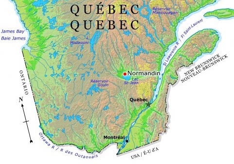
Normandin
On 14 February 1979, the city of Normandin was created by the amalgamation of the village of Normandin and the parish of Normandin. However, its history began on 23 May 1733 when Joseph-Laurent Normandin was sent to survey this region and prepare a map of the lakes and rivers.
"https://d3d0lqu00lnqvz.cloudfront.net/media/media/7ada88f5-5e3d-400d-8c7d-a85dc4d72e8c.jpg" // resources/views/front/categories/view.blade.php
https://d3d0lqu00lnqvz.cloudfront.net/media/media/7ada88f5-5e3d-400d-8c7d-a85dc4d72e8c.jpg