
Browse "Places"
-
Article
North Cape
North Cape, also called North Port, is the northern extremity of Prince Edward Island, dividing Northumberland Strait from the Gulf of St Lawrence proper.
"https://thecanadianencyclopedia.ca/images/tce_placeholder.jpg?v=e9dca980c9bdb3aa11e832e7ea94f5d9" // resources/views/front/categories/view.blade.php
https://thecanadianencyclopedia.ca/images/tce_placeholder.jpg?v=e9dca980c9bdb3aa11e832e7ea94f5d9
-
Article
North Cowichan
North Cowichan, BC, incorporated as a district municipality in 1873, population 28 807 (2011c), 27 557 (2006c). The Municipality of North Cowichan is located on the east coast of VANCOUVER ISLAND about halfway between Nanaimo and Victoria.
"https://d3d0lqu00lnqvz.cloudfront.net/media/media/ce2915be-f93b-4a88-b0e0-316d5c6a246f.jpg" // resources/views/front/categories/view.blade.php
https://d3d0lqu00lnqvz.cloudfront.net/media/media/ce2915be-f93b-4a88-b0e0-316d5c6a246f.jpg
-
Article
North Hills Museum
North Hills Museum is located in Granville Ferry, NS, on the shores of the historic Annapolis Basin. The museum is housed in a 200-year-old "salt box" house originally known as Rumsey Farm.
"https://thecanadianencyclopedia.ca/images/tce_placeholder.jpg?v=e9dca980c9bdb3aa11e832e7ea94f5d9" // resources/views/front/categories/view.blade.php
https://thecanadianencyclopedia.ca/images/tce_placeholder.jpg?v=e9dca980c9bdb3aa11e832e7ea94f5d9
-
Article
North Pole
The North Pole is the Earth's northernmost geographic point, located at the northern end of the Earth's axis. The pole lies in the Arctic Ocean, more than 720 km north of Ellesmere Island, at a point where the ocean is 4,087 m deep and usually covered with drifting pack ice. The pole experiences six months of complete sunlight and six months of night each year; from it, all directions are south. Because the Earth's surface areas near the North and South poles receive the sun's rays at the most slanted angle, they absorb the least heat. Centrifugal force causes the Earth to bulge outwards at the equator; hence, it is slightly flattened at the poles. However, during the International Geophysical Year (1957–58), it was found that the Earth is very slightly pear-shaped, with the North Pole at the smaller end. This bulge (about 15 m high) covers millions of square kilometres around the pole.
"https://d3d0lqu00lnqvz.cloudfront.net/media/new_article_images/ArcticOcean/ArcticOceanMapEN.jpg" // resources/views/front/categories/view.blade.php
https://d3d0lqu00lnqvz.cloudfront.net/media/new_article_images/ArcticOcean/ArcticOceanMapEN.jpg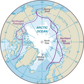
-
Article
North Saanich
North Saanich, BC, incorporated as a district municipality in 1965, population 11 089 (2011c), 10 823 (2006c). The District of North Saanich is one of three district municipalities on the Saanich Peninsula about 27 km north of Victoria.
"https://d3d0lqu00lnqvz.cloudfront.net/media/media/dee732ba-3897-4661-8537-d19601c1bfee.jpg" // resources/views/front/categories/view.blade.php
https://d3d0lqu00lnqvz.cloudfront.net/media/media/dee732ba-3897-4661-8537-d19601c1bfee.jpg
-
Article
North Saskatchewan River
The North Saskatchewan River (1,287 km long, the first 48.5 km of which is designated as a Canadian Heritage River) is a major tributary to the Saskatchewan River, which ultimately flows into Hudson Bay. The mean annual flow is 241 m3/s; however, flow varies between the peak in July and minimum in February. It served as a major transportation route from the end of the last Ice Age through the mid-20th century.
"https://d3d0lqu00lnqvz.cloudfront.net/media/media/98d61a99-4200-4393-92c7-61a42587d6cf.jpg" // resources/views/front/categories/view.blade.php
https://d3d0lqu00lnqvz.cloudfront.net/media/media/98d61a99-4200-4393-92c7-61a42587d6cf.jpg
-
Article
North Vancouver
North Vancouver, British Columbia, incorporated as a district in 1891, population 85,935 (2016 census), 84,412 (2011 census); also, a separate entity incorporated as a city in 1907, population 52,898 (2016 census), 48,196 (2011 census). The district of North Vancouver and the city of North Vancouver are located in southwestern British Columbia, adjacent to the city of Vancouver. Situated on the north shore of Burrard Inlet, North Vancouver extends from the Capilano River on the west to beyond Deep Cove on the east. The district surrounds the city, which is centered on Lonsdale Avenue, except at the waterfront. Elevations in North Vancouver range from sea level to 1,400 metres. The North Shore mountains — such as Grouse and Seymour — form a scenic backdrop.
"https://d3d0lqu00lnqvz.cloudfront.net/media/new_article_images/NorthVancouver/North Vancouver_2016.jpg" // resources/views/front/categories/view.blade.php
https://d3d0lqu00lnqvz.cloudfront.net/media/new_article_images/NorthVancouver/North Vancouver_2016.jpg
-
Article
North-West Territories (1870–1905)
The North-West Territories was the first Canadian territory. It was Established on 15 July 1870. As a territory, the region became part of Canada. But it lacked the population, economic and infrastructure resources to attain provincial status. It thus fell under the jurisdiction of the federal government. It covered a vast area, stretching west from a disputed boundary with Labrador, across the northern portions of present-day Quebec and Ontario, through the Prairies to British Columbia, and north from the 49th parallel to the Arctic Ocean. The territory was subject to numerous boundary changes before 1905. At that time, the provinces of Saskatchewan and Alberta were carved out of the southwest portion of the region. In 1906, the remaining territory was renamed the Northwest Territories.
"https://d3d0lqu00lnqvz.cloudfront.net/media/media/1ca2e02a-e2e8-4709-acee-5581d6051d5c.jpg" // resources/views/front/categories/view.blade.php
https://d3d0lqu00lnqvz.cloudfront.net/media/media/1ca2e02a-e2e8-4709-acee-5581d6051d5c.jpg
-
Article
North York
North York, Ontario, Urban Community within the city of Toronto. North York was a city (incorporated from 1979 to 1998) until it was amalgamated into the new megacity of TORONTO in 1998.
"https://d3d0lqu00lnqvz.cloudfront.net/media/media/c23a342f-ed21-417e-896b-1565a1f1be1b.jpg" // resources/views/front/categories/view.blade.php
https://d3d0lqu00lnqvz.cloudfront.net/media/media/c23a342f-ed21-417e-896b-1565a1f1be1b.jpg
-
Article
Northumberland Strait
A generally shallow depth causes strong tidal currents, water turbulence and a high concentration of suspended red silt and clay, which led early French colonists to name the strait "la mer rouge.
"https://d3d0lqu00lnqvz.cloudfront.net/media/media/d2e73a66-567c-4b92-ab82-e34c1cba8a41.jpg" // resources/views/front/categories/view.blade.php
https://d3d0lqu00lnqvz.cloudfront.net/media/media/d2e73a66-567c-4b92-ab82-e34c1cba8a41.jpg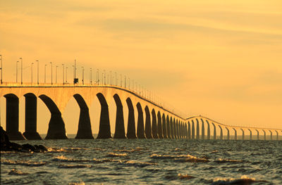
-
Article
Northwest Coast
The Northwest Coast is the western coast of Canada and the United States along the Pacific Ocean. This term originates from 18th-century European navigators and traders referring to the great arc of the Pacific coast and offshore islands stretching from present-day northern California to an ill-defined point along the Alaska coast—at Prince William Sound or even Cook Inlet. This region is known for its natural beauty and its rich history of Indigenous art (see Northwest Coast Indigenous Art).
"https://d3d0lqu00lnqvz.cloudfront.net/nootkasound/Nootka-Sound.jpg" // resources/views/front/categories/view.blade.php
https://d3d0lqu00lnqvz.cloudfront.net/nootkasound/Nootka-Sound.jpg
-
Article
Northwest Passage
The Northwest Passage is a sea corridor through Canada's Arctic archipelago and along the northern coast of North America. European explorers searched in vain for the passage for 300 years, intent on finding a commercially viable western sea route between Europe and Asia. Climate change may now be opening the once ice-bound passage to more regular shipping.
"https://d3d0lqu00lnqvz.cloudfront.net/media/media/acca04c0-f3cc-448d-b29a-0b7dbefd6ade.jpg" // resources/views/front/categories/view.blade.php
https://d3d0lqu00lnqvz.cloudfront.net/media/media/acca04c0-f3cc-448d-b29a-0b7dbefd6ade.jpg
-
Article
Northwest Staging Route
The Northwest Staging Route, an air route from Edmonton, over northwestern Canada to Fairbanks, Alaska, was planned before WWII by Canada, developed and built by Canada and the US between 1940-44.
"https://thecanadianencyclopedia.ca/images/tce_placeholder.jpg?v=e9dca980c9bdb3aa11e832e7ea94f5d9" // resources/views/front/categories/view.blade.php
https://thecanadianencyclopedia.ca/images/tce_placeholder.jpg?v=e9dca980c9bdb3aa11e832e7ea94f5d9
-
Article
Northwest Territories
The Northwest Territories lie northwest of central Canada, bordered to the east by Nunavut, to the west by the Yukon and to the south by the northeastern corner of British Columbia, as well as the entire northern borders of Alberta and Saskatchewan. The name was originally applied to the territory acquired in 1870 from the Hudson's Bay Company and Great Britain: Rupert’s Land and the North-Western Territory. In 1880 Great Britain also transferred to Canada the arctic islands, north of the mainland, thereby adding to the territories. The acquisition of the NWT was a major component of the Canadian government’s desire, led by Sir John A. MacDonald, to construct a British nation in North America and to guard against the potential incursion of American settlers.
"https://d3d0lqu00lnqvz.cloudfront.net/media/media/990fab4d-1900-4928-acde-c8b11f9c52dd.jpg" // resources/views/front/categories/view.blade.php
https://d3d0lqu00lnqvz.cloudfront.net/media/media/990fab4d-1900-4928-acde-c8b11f9c52dd.jpg
-
Timelines
Northwest Territories
The Northwest Territories lie northwest of central Canada, bordered to the east by Nunavut, to the west by the Yukon and to the south by the northeastern corner of British Columbia, as well as the entire northern borders of Alberta and Saskatchewan.
"https://d3d0lqu00lnqvz.cloudfront.net/media/media/a97bb3a4-ac75-4b97-94e5-5fcb9fe2b922.jpg" // resources/views/front/categories/view.blade.php
https://d3d0lqu00lnqvz.cloudfront.net/media/media/a97bb3a4-ac75-4b97-94e5-5fcb9fe2b922.jpg