
Browse "Places"
-
Article
Pembroke
Long associated with the lumber trade, the city currently produces wood and paper products in addition to other light manufacturing. The seat of Renfrew County, it is also the commercial and service centre of the region.
"https://thecanadianencyclopedia.ca/images/tce_placeholder.jpg?v=e9dca980c9bdb3aa11e832e7ea94f5d9" // resources/views/front/categories/view.blade.php
https://thecanadianencyclopedia.ca/images/tce_placeholder.jpg?v=e9dca980c9bdb3aa11e832e7ea94f5d9
-
Article
Penetanguishene
The earliest European visitors were Étienne BRÛLÉ and Samuel de CHAMPLAIN, developing links between New France and the HURON.
"https://thecanadianencyclopedia.ca/images/tce_placeholder.jpg?v=e9dca980c9bdb3aa11e832e7ea94f5d9" // resources/views/front/categories/view.blade.php
https://thecanadianencyclopedia.ca/images/tce_placeholder.jpg?v=e9dca980c9bdb3aa11e832e7ea94f5d9
-
Article
Penticton
Penticton, British Columbia, incorporated as a city in 1948, population 33,761 (2016 census), 32,877 (2011 census). The City of Penticton is nestled between Okanagan and Skaha lakes in south-central British Columbia.
"https://d3d0lqu00lnqvz.cloudfront.net/media/media/f209d009-7b9e-4d16-bcb5-b04871cc4521.jpg" // resources/views/front/categories/view.blade.php
https://d3d0lqu00lnqvz.cloudfront.net/media/media/f209d009-7b9e-4d16-bcb5-b04871cc4521.jpg
-
Article
Percé
Percé's history is as old as that of NEW FRANCE. Jacques CARTIER arrived there in 1534, and European fishermen used the bay as a haven in the 16th and 17th centuries.
"https://thecanadianencyclopedia.ca/images/tce_placeholder.jpg?v=e9dca980c9bdb3aa11e832e7ea94f5d9" // resources/views/front/categories/view.blade.php
https://thecanadianencyclopedia.ca/images/tce_placeholder.jpg?v=e9dca980c9bdb3aa11e832e7ea94f5d9
-
Article
Percé Rock
Percé Rock (or Rocher Percé) is a monolith off the Gaspé Peninsula, 750 km east of Québec City, near its namesake, the town of Percé.
"https://d3d0lqu00lnqvz.cloudfront.net/media/media/ad3866be-b4ea-484b-a7c6-4e112b36cf85.jpg" // resources/views/front/categories/view.blade.php
https://d3d0lqu00lnqvz.cloudfront.net/media/media/ad3866be-b4ea-484b-a7c6-4e112b36cf85.jpg
-
Article
Perkins House
Perkins House in LIVERPOOL, NS, was built for Simeon PERKINS, who came from Connecticut and was one of the town's leading citizens in the late 18th century. Perkins was a merchant, shipowner and a colonel in the militia as well as being a judge and a member of the legislative assembly.
"https://d3d0lqu00lnqvz.cloudfront.net/media/media/bbbe3707-be09-4f1f-bf96-96e25202dc8d.jpg" // resources/views/front/categories/view.blade.php
https://d3d0lqu00lnqvz.cloudfront.net/media/media/bbbe3707-be09-4f1f-bf96-96e25202dc8d.jpg
-
Article
Persephone Theatre
Named after the daughter of Demeter, sponsor of agriculture and of the changing seasons in Greek myth, Persephone Theatre was founded in 1974 by Brian Richmond, and Susan and Janet Wright. Its first mandate was to deliver professional theatre from the Canadian and international repertoire to Saskatoon audiences. By 1978, Persephone's declared mandate was to serve as a community-based regional theatre for Saskatoon and its surrounding area.
"https://d3d0lqu00lnqvz.cloudfront.net/media/media/e642830b-0e9e-47e2-abc2-a719bcbff38c.jpg" // resources/views/front/categories/view.blade.php
https://d3d0lqu00lnqvz.cloudfront.net/media/media/e642830b-0e9e-47e2-abc2-a719bcbff38c.jpg
-
Article
Perth
Cheese making has always been an important local industry. In 1893 a local cheese weighing 9979 kg and measuring 1.8 m high and 8.56 m around was sent to the Chicago world's fair.
"https://thecanadianencyclopedia.ca/images/tce_placeholder.jpg?v=e9dca980c9bdb3aa11e832e7ea94f5d9" // resources/views/front/categories/view.blade.php
https://thecanadianencyclopedia.ca/images/tce_placeholder.jpg?v=e9dca980c9bdb3aa11e832e7ea94f5d9
-
Article
Petawawa
The township was surveyed in 1857, but it attracted few settlers until 1904, when the Canadian government chose it as the site for a new military camp. Camp PETAWAWA eventually grew to encompass large portions of 4 townships, and has become one of Canada's most important military bases.
"https://thecanadianencyclopedia.ca/images/tce_placeholder.jpg?v=e9dca980c9bdb3aa11e832e7ea94f5d9" // resources/views/front/categories/view.blade.php
https://thecanadianencyclopedia.ca/images/tce_placeholder.jpg?v=e9dca980c9bdb3aa11e832e7ea94f5d9
-
Article
Peterborough
Peterborough, Ontario, incorporated as a city in 1905, population 83,651 (2021 census), 81,032 (2016 census). The City of Peterborough is situated on the Otonabee River, about 40 km north of Lake Ontario and 110 km northeast of Toronto. The seat of Peterborough County, it is the largest city on the Trent-Severn Waterway and the regional centre for the Kawartha Lakes cottage country.
"https://d3d0lqu00lnqvz.cloudfront.net/Peterborough.jpg" // resources/views/front/categories/view.blade.php
https://d3d0lqu00lnqvz.cloudfront.net/Peterborough.jpg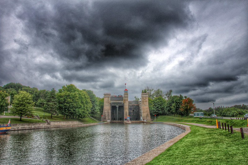
-
Article
Music in Peterborough
Ontario city on the Otonabee River (part of the Trent-Severn Waterway). It was settled ca 1820 by County Cork Irish, was named Peterborough in 1827, and was incorporated in 1905. It developed into a lumbering and milling town.
"https://thecanadianencyclopedia.ca/images/tce_placeholder.jpg?v=e9dca980c9bdb3aa11e832e7ea94f5d9" // resources/views/front/categories/view.blade.php
https://thecanadianencyclopedia.ca/images/tce_placeholder.jpg?v=e9dca980c9bdb3aa11e832e7ea94f5d9
-
Article
Petit Rocher
Petit Rocher, NB, incorporated as a village in 1966, population 1908 (2011c), 1949 (2006c). The Village of Petit Rocher is located on Chaleur Bay near BATHURST.
"https://d3d0lqu00lnqvz.cloudfront.net/media/media/f4d5838c-a5b8-41dd-968f-8704190af9c1.jpg" // resources/views/front/categories/view.blade.php
https://d3d0lqu00lnqvz.cloudfront.net/media/media/f4d5838c-a5b8-41dd-968f-8704190af9c1.jpg
-
Article
Petroglyphs Provincial Park
Petroglyphs Provincial Park (established 1976, 1643 ha) is the site of one of Canada's archaeological and cultural treasures. On a flat expanse of rock are some 900 carvings or petroglyphs of symbolic shapes and figures, likely carved by Algonquian-speaking people. Established as a historic-class park, Petroglyphs Provincial Park is located 55 km northeast of Peterborough, Ontario. It is located on the southern edge of the Canadian Shield and in a transition zone between the Shield and the Great Lakes-St Lawrence Lowland area. Rocky ridges covered with thin soil are interspersed with low-lying wetlands.
"https://thecanadianencyclopedia.ca/images/tce_placeholder.jpg?v=e9dca980c9bdb3aa11e832e7ea94f5d9" // resources/views/front/categories/view.blade.php
https://thecanadianencyclopedia.ca/images/tce_placeholder.jpg?v=e9dca980c9bdb3aa11e832e7ea94f5d9
-
Article
Petrolia
Petrolia, Ontario, incorporated as a town in 1874, population 6,013 (2021 census), 5,742 (2016 census). The Town of Petrolia is located 30 km southeast of Sarnia, and west of London.
"https://d3d0lqu00lnqvz.cloudfront.net/media/media/f1f229e0-2c11-4266-a7af-2069e82bc0c9.jpg" // resources/views/front/categories/view.blade.php
https://d3d0lqu00lnqvz.cloudfront.net/media/media/f1f229e0-2c11-4266-a7af-2069e82bc0c9.jpg
-
Article
Phillip's Garden
Phillip’s Garden is one of North America's most intensively occupied Dorset (Tuniit) archaeological sites. Located in northwestern Newfoundland on the Point Riche peninsula, it lies near the community of Port au Choix. The area around Port au Choix has an extensive history of human habitation dating back nearly 6,500 years. Unlike most Dorset sites, which tend to have only a few houses or tent rings and were occupied seasonally, Phillip’s Garden has over 160 houses, making it one of the largest known Dorset sites in North America. The relatively consistent Dorset habitation at Phillip’s Garden was made possible by the rich marine food sources that were readily accessible at the site.
"https://d3d0lqu00lnqvz.cloudfront.net/phillipsgarden/Seal-Migration-Map.png" // resources/views/front/categories/view.blade.php
https://d3d0lqu00lnqvz.cloudfront.net/phillipsgarden/Seal-Migration-Map.png