
Browse "Parks & Nature Reserves"
-
Article
Key Biodiversity Areas of Canada
Key Biodiversity Areas (KBAs) are sites that play an outsized role in supporting the survival of species and ecosystems around the world. They are identified through rigorous scientific assessment using internationally standardized criteria developed by the International Union for Conservation of Nature (IUCN). Canada has about 800 KBAs, including candidate sites. They are found across marine, freshwater, terrestrial and subterranean environments, spotlighting key sites for iconic species like polar bears and puffins, and for lesser-known Canadian biodiversity, like slugs, lichens and rare dune ecosystems. KBAs recognize the diversity and significance of Canada’s nature, helping governments, Indigenous communities, conservation organizations, researchers and others prioritize areas for conservation.
"https://d3d0lqu00lnqvz.cloudfront.net/media/media/c0640ae1-86d9-41e2-9a94-5f392651fc8e.jpg" // resources/views/front/categories/view.blade.php
https://d3d0lqu00lnqvz.cloudfront.net/media/media/c0640ae1-86d9-41e2-9a94-5f392651fc8e.jpg
-
Article
Killarney Provincial Park
Natural History The park's most striking feature is a series of rock ridges consisting mostly of white quartzite. These large, rounded hills are the remains of the La Cloche range, a ring of Precambrian mountains that once towered higher than the present-day Rockies.
"https://d3d0lqu00lnqvz.cloudfront.net/media/media/6c7cc9d2-c509-4259-a224-57a0a1216afa.jpg" // resources/views/front/categories/view.blade.php
https://d3d0lqu00lnqvz.cloudfront.net/media/media/6c7cc9d2-c509-4259-a224-57a0a1216afa.jpg
-
Article
Kluane National Park and Reserve
Kluane National Park and Reserve (established 1976, 21,980 km2) is an area of unclimbed peaks, vast ice fields, clear lakes, glaciers and spectacular wildlife. Tucked in the southwest corner of the Yukon Territory, 150 km west of Whitehorse, Kluane (pronounced kloo-AH-nee) contains Canada’s highest peak, Mount Logan. It is named after Yukon’s largest lake, which borders the park. The park and park reserve, together with Tatshenshini-Alsek Wilderness Provincial Park in British Columbia and Glacier Bay and Wrangell-St. Elias national parks in Alaska, form an international UNESCO World Heritage Site covering over 98,391 km2.
"https://d3d0lqu00lnqvz.cloudfront.net/media/media/eaf72296-f152-4658-8249-bbf7a8b70296.jpg" // resources/views/front/categories/view.blade.php
https://d3d0lqu00lnqvz.cloudfront.net/media/media/eaf72296-f152-4658-8249-bbf7a8b70296.jpg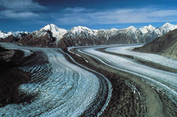
-
Article
Kootenay National Park
Kootenay National Park (established 1920, 1406.4 km2) is located on the west slope of the Continental Divide. The park, stretching north and south for 104 km, is bounded on the east by Banff and Mount Assiniboine Provincial Park on the north by Yoho National Park.
"https://d3d0lqu00lnqvz.cloudfront.net/media/media/1aa8fafc-a0a0-48c9-86a8-6e588b13ecfe.jpg" // resources/views/front/categories/view.blade.php
https://d3d0lqu00lnqvz.cloudfront.net/media/media/1aa8fafc-a0a0-48c9-86a8-6e588b13ecfe.jpg
-
Article
Lake Superior Provincial Park
Lake Superior Provincial Park (established 1944, 1556 km2), located north of Sault Ste Marie, Ontario, includes part of the wild shoreline of eastern Lake Superior and a hinterland of rugged, forested Canadian Shield country.
"https://d3d0lqu00lnqvz.cloudfront.net/media/media/670a98ba-b8c3-47aa-92f9-ac92cf084645.jpg" // resources/views/front/categories/view.blade.php
https://d3d0lqu00lnqvz.cloudfront.net/media/media/670a98ba-b8c3-47aa-92f9-ac92cf084645.jpg
-
Article
Lakeland Provincial Park
A landscape of forests and lakes, Lakeland Provincial Park (established 1992, 147 km2) is located east of LAC LA BICHE about 250 km northeast of Edmonton.
"https://thecanadianencyclopedia.ca/images/tce_placeholder.jpg?v=e9dca980c9bdb3aa11e832e7ea94f5d9" // resources/views/front/categories/view.blade.php
https://thecanadianencyclopedia.ca/images/tce_placeholder.jpg?v=e9dca980c9bdb3aa11e832e7ea94f5d9
-
List
Largest National Parks in Canada
Canada has 48 national parks and national park reserves, as well as one national urban park (see also National Parks of Canada). They protect important land and marine habitats, geographical features and sites of cultural significance. National parks also benefit local economies and the tourism industry in Canada. In total, the parks cover more than 340,000 km2, which is over 3 per cent of Canada’s landmass. Nearly all of Canada’s largest national parks are located in the north, and five of them in Nunavut.
"https://d3d0lqu00lnqvz.cloudfront.net/media/new_article_images/LargestNationalParks/WoodBuffaloNationalPark.jpg" // resources/views/front/categories/view.blade.php
https://d3d0lqu00lnqvz.cloudfront.net/media/new_article_images/LargestNationalParks/WoodBuffaloNationalPark.jpg
-
Article
Lesser Slave Lake Provincial Park
Located 260 km north of Edmonton on the east side of Alberta's second largest lake, Lesser Slave Lake Provincial Park (established 1966, 73 km2) is a landscape of contrasts.
"https://d3d0lqu00lnqvz.cloudfront.net/media/media/4ec4a212-b4ef-4fde-844a-ba30ef433515.jpg" // resources/views/front/categories/view.blade.php
https://d3d0lqu00lnqvz.cloudfront.net/media/media/4ec4a212-b4ef-4fde-844a-ba30ef433515.jpg
-
Article
Meares Island
Meares Island, 84.8 km2 of dramatic terrain, temperate rain forest and sheltered tidal waters, is 2 km from Tofino, BC, in Clayoquot Sound. It was named in 1862 after John Meares. Its traditional name is Wanachus-Hilthuuis, from the Nuu-chah-nulth language.
"https://thecanadianencyclopedia.ca/images/tce_placeholder.jpg?v=e9dca980c9bdb3aa11e832e7ea94f5d9" // resources/views/front/categories/view.blade.php
https://thecanadianencyclopedia.ca/images/tce_placeholder.jpg?v=e9dca980c9bdb3aa11e832e7ea94f5d9
-
Article
Mount Assiniboine Provincial Park
Mount Assiniboine Provincial Park (est 1922, 386 km 2 ) is an area of mountain peaks, alpine meadows and lakes dominated by Mount ASSINIBOINE (about 35 km south of BANFF , Alberta). The park, which is mainly above 1500 m,
"https://thecanadianencyclopedia.ca/images/tce_placeholder.jpg?v=e9dca980c9bdb3aa11e832e7ea94f5d9" // resources/views/front/categories/view.blade.php
https://thecanadianencyclopedia.ca/images/tce_placeholder.jpg?v=e9dca980c9bdb3aa11e832e7ea94f5d9
-
Article
Mount Carleton Provincial Park
New Brunswick's largest PROVINCIAL PARK, Mount Carleton Provincial Park (established 1970, 174.27 km2), features forests and abundant wildlife.
"https://thecanadianencyclopedia.ca/images/tce_placeholder.jpg?v=e9dca980c9bdb3aa11e832e7ea94f5d9" // resources/views/front/categories/view.blade.php
https://thecanadianencyclopedia.ca/images/tce_placeholder.jpg?v=e9dca980c9bdb3aa11e832e7ea94f5d9
-
Article
Mount Edziza Provincial Park
Mount Edziza Provincial Park (est 1972, 2300 km 2 ha) comprises part of the Tahltan Highlands, between the Stikine and Iskut rivers in BC. The nearest community is Telegraph Creek, 20 km northwest of the park.
"https://thecanadianencyclopedia.ca/images/tce_placeholder.jpg?v=e9dca980c9bdb3aa11e832e7ea94f5d9" // resources/views/front/categories/view.blade.php
https://thecanadianencyclopedia.ca/images/tce_placeholder.jpg?v=e9dca980c9bdb3aa11e832e7ea94f5d9
-
Article
Mount Revelstoke National Park
Mount Revelstoke National Park (est 1914, 259.7 km2) is a place of contrasting landscape, varying from rain forests and lush alpine meadows to barren, rocky ridges and glaciers. The jagged spires of the Selkirk Mountains are the backdrop for this park. Grizzly bear and caribou range throughout, while mountain goats frequent the rocky bluffs. Due to the small size of the park, and extensive clear-cut logging in adjacent lands, the park lacks ecological integrity, and its populations of large mammals, particularly caribou, are threatened. Alpine meadows feature pika, hoary marmot and golden-mantled ground squirrel, often under the gaze of the golden eagle. Between October and June the park is covered in a thick blanket of snow, but in the brief summer, meadows glow with the blossoms of lupine, aster and Indian paintbrush. The Meadows in the Sky Parkway provides road access to lush alpine meadows.
"https://d3d0lqu00lnqvz.cloudfront.net/media/media/d2b11ccd-0a14-4857-aafd-b31bb02c12ec.jpg" // resources/views/front/categories/view.blade.php
https://d3d0lqu00lnqvz.cloudfront.net/media/media/d2b11ccd-0a14-4857-aafd-b31bb02c12ec.jpg
-
Timelines
National Parks
Canada's national parks are protected areas established under federal legislation to preserve Canada's natural heritage.
"https://d3d0lqu00lnqvz.cloudfront.net/media/media/be7a97e5-19d2-4df5-b348-a549dd5b3fe7.jpg" // resources/views/front/categories/view.blade.php
https://d3d0lqu00lnqvz.cloudfront.net/media/media/be7a97e5-19d2-4df5-b348-a549dd5b3fe7.jpg
-
Article
National Parks of Canada
Canada’s national parks are protected areas established under federal legislation to preserve Canada’s natural heritage. They are administered by Parks Canada, a government agency that evolved from the world’s first national parks service, the Dominion Parks Branch, established in 1911. The National Parks System Plan, developed in 1970, divided Canada into 39 natural regions and set the goal of representing each region with at least one national park. Canada now has 48 national parks and national park reserves, and one national urban park, in 30 of these regions. In total, the parks cover more than 340,000 km2, which is over 3 per cent of Canada’s landmass. They protect important land and marine habitats, geographical features and sites of cultural significance. National parks also benefit local economies and the tourism industry in Canada. This is a full-length entry about the national parks of Canada. For a plain-language summary, please see National Parks of Canada (Plain-Language Summary).
"https://d3d0lqu00lnqvz.cloudfront.net/media/media/27f9bb3e-3454-4b12-9aca-ded0299bfe8c.jpg" // resources/views/front/categories/view.blade.php
https://d3d0lqu00lnqvz.cloudfront.net/media/media/27f9bb3e-3454-4b12-9aca-ded0299bfe8c.jpg