
Browse "Historic Sites"
-
Article
Old Log Church Museum
The Old Log Church Museum is an Anglican church, built in 1900 in Whitehorse, Yukon Territory.
"https://d3d0lqu00lnqvz.cloudfront.net/media/media/bf260975-3834-45d5-82ea-1e34363b2b26.jpg" // resources/views/front/categories/view.blade.php
https://d3d0lqu00lnqvz.cloudfront.net/media/media/bf260975-3834-45d5-82ea-1e34363b2b26.jpg
-
Article
Old Meeting House and Barrington Woolen Mill
The Barrington Woolen Mill is a typical late-19th-century mill. Established in 1882, the mill operated up to 1962. It is perhaps most notable for its excellent collection of looms, spinning jennies, carding machines and other early mill equipment and machinery.
"https://d3d0lqu00lnqvz.cloudfront.net/media/media/b025b87d-c65d-40cc-af2a-c487a30e8c2c.jpg" // resources/views/front/categories/view.blade.php
https://d3d0lqu00lnqvz.cloudfront.net/media/media/b025b87d-c65d-40cc-af2a-c487a30e8c2c.jpg
-
Article
Oxbow Archaeological Site
The Oxbow site is located on a low terrace along the north bank of the Little Southwest Miramichi River, 1 km west of its confluence with the Northwest Miramichi, Northumberland County, New Brunswick.
"https://d3d0lqu00lnqvz.cloudfront.net/media/media/0ca6861b-eca0-4e2e-a2dd-b774d34d4352.jpg" // resources/views/front/categories/view.blade.php
https://d3d0lqu00lnqvz.cloudfront.net/media/media/0ca6861b-eca0-4e2e-a2dd-b774d34d4352.jpg
-
Article
Paldi
Paldi, British Columbia was established in 1917, about 75 km northwest of Victoria. It was one of the first multi-ethnic, migrant mill towns on Vancouver Island. Sikh entrepreneur Mayo Singh (born Mayan Singh Manhas) founded the community. He named Paldi after his own village in District Hoshiarpur in Punjab, India. (Singh originally named Paldi after himself, calling the settlement Mayo Siding. However, because there was already a town named Mayo in Yukon, Singh changed the name to Paldi in 1936.) Though Paldi no longer has a registered population, it remains a symbol of successful, intercultural living in Canada.
"https://d3d0lqu00lnqvz.cloudfront.net/MayoSingh/ChildrenAndTemple.jpg" // resources/views/front/categories/view.blade.php
https://d3d0lqu00lnqvz.cloudfront.net/MayoSingh/ChildrenAndTemple.jpg
-
Article
Perkins House
Perkins House in LIVERPOOL, NS, was built for Simeon PERKINS, who came from Connecticut and was one of the town's leading citizens in the late 18th century. Perkins was a merchant, shipowner and a colonel in the militia as well as being a judge and a member of the legislative assembly.
"https://d3d0lqu00lnqvz.cloudfront.net/media/media/bbbe3707-be09-4f1f-bf96-96e25202dc8d.jpg" // resources/views/front/categories/view.blade.php
https://d3d0lqu00lnqvz.cloudfront.net/media/media/bbbe3707-be09-4f1f-bf96-96e25202dc8d.jpg
-
Article
Phillip's Garden
Phillip’s Garden is one of North America's most intensively occupied Dorset (Tuniit) archaeological sites. Located in northwestern Newfoundland on the Point Riche peninsula, it lies near the community of Port au Choix. The area around Port au Choix has an extensive history of human habitation dating back nearly 6,500 years. Unlike most Dorset sites, which tend to have only a few houses or tent rings and were occupied seasonally, Phillip’s Garden has over 160 houses, making it one of the largest known Dorset sites in North America. The relatively consistent Dorset habitation at Phillip’s Garden was made possible by the rich marine food sources that were readily accessible at the site.
"https://d3d0lqu00lnqvz.cloudfront.net/phillipsgarden/Seal-Migration-Map.png" // resources/views/front/categories/view.blade.php
https://d3d0lqu00lnqvz.cloudfront.net/phillipsgarden/Seal-Migration-Map.png
-
Article
Pier 21
Pier 21 was an immigration depot on the Halifax harbourfront that operated from 1928 to 1971.
"https://d3d0lqu00lnqvz.cloudfront.net/media/media/fd704360-23a5-4333-9dc4-fed52fcc81b8.jpg" // resources/views/front/categories/view.blade.php
https://d3d0lqu00lnqvz.cloudfront.net/media/media/fd704360-23a5-4333-9dc4-fed52fcc81b8.jpg
-
Article
Point Amour Lighthouse
In 1858 the Point Amour Lighthouse was built to help sailors through the dangerous waters of the Strait of Belle Isle between Labrador and Newfoundland.
"https://thecanadianencyclopedia.ca/images/tce_placeholder.jpg?v=e9dca980c9bdb3aa11e832e7ea94f5d9" // resources/views/front/categories/view.blade.php
https://thecanadianencyclopedia.ca/images/tce_placeholder.jpg?v=e9dca980c9bdb3aa11e832e7ea94f5d9
-
Article
Pointe-du-Buisson Archaeological Sites
Pointe-du-Buisson is a small point of land (21 ha) extending into the waters of Lake St Louis (a widening of the St-Lawrence River) at the convergence of the Ottawa River.
"https://d3d0lqu00lnqvz.cloudfront.net/media/media/b8bf0f8e-3c7a-4b11-9fa4-efe4e14a1650.jpg" // resources/views/front/categories/view.blade.php
https://d3d0lqu00lnqvz.cloudfront.net/media/media/b8bf0f8e-3c7a-4b11-9fa4-efe4e14a1650.jpg
-
Article
Port of Quebec
Throughout its history, the Port of Quebec has undergone numerous changes reflecting the needs and concerns of the day. From its initial military role under the French regime, the Port of Quebec turned to commerce and transformed radically in the 19th century as a result of the timber trade and immigration. These two new realities had major repercussions on the port’s development, which adapted to accommodate ships of increasingly higher tonnage. With its sizable ocean port, the third largest in North America after New York and New Orleans, Quebec became the primary gateway to Canada for hundreds of thousands of immigrants arriving by sea.
"https://d3d0lqu00lnqvz.cloudfront.net/media/new_article_images/portdequebec/1024px-Quebec-Maasdam.JPG" // resources/views/front/categories/view.blade.php
https://d3d0lqu00lnqvz.cloudfront.net/media/new_article_images/portdequebec/1024px-Quebec-Maasdam.JPG
-
Article
Port-Royal National Historic Site
Located in Nova Scotia, Port-Royal National Historic Site features a reconstruction of the Port-Royal Habitation, one of the first settlements attempted by the French in North America (1605). Administered by Parks Canada, this historic site offers interpretive activities that convey the French settlers’ challenges in implementing the new colony. Visitors can also learn about the culture of the Mi’kmaq, the area’s first inhabitants of the land.
"https://d3d0lqu00lnqvz.cloudfront.net/media/media/64771090-5008-4ccf-9621-b6602042e7de.jpg" // resources/views/front/categories/view.blade.php
https://d3d0lqu00lnqvz.cloudfront.net/media/media/64771090-5008-4ccf-9621-b6602042e7de.jpg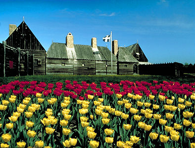
-
Article
Province House - Halifax
Province House, Halifax, built between 1811 and 1818 to house Parliament, the courts and the public service of Nova Scotia.
"https://thecanadianencyclopedia.ca/images/tce_placeholder.jpg?v=e9dca980c9bdb3aa11e832e7ea94f5d9" // resources/views/front/categories/view.blade.php
https://thecanadianencyclopedia.ca/images/tce_placeholder.jpg?v=e9dca980c9bdb3aa11e832e7ea94f5d9
-
Article
Province House, Charlottetown
Province House in Charlottetown is the home of Prince Edward Island's Legislative Assembly.
"https://thecanadianencyclopedia.ca/images/tce_placeholder.jpg?v=e9dca980c9bdb3aa11e832e7ea94f5d9" // resources/views/front/categories/view.blade.php
https://thecanadianencyclopedia.ca/images/tce_placeholder.jpg?v=e9dca980c9bdb3aa11e832e7ea94f5d9
-
Article
Qajartalik
Qajartalik (pronounced k-eye-yar-tal-ick, meaning “where there is a kayak” in Inuktitut) is the largest and most well-studied site containing evidence of petroglyphs in the Canadian Arctic. Petroglyphs are a type of rock art made by carving directly into a rock panel. Qajartalik is one of only four known sites in the Canadian Arctic and Greenland with petroglyphs. All these petroglyph sites are located on the northeastern coast of the Ungava Peninsula. Based on the artistic style of the carved images, archaeologists believe the Dorset people, also known as the Tuniit in Inuit oral histories, from the latter third of their cultural period made them. This would mean the petroglyphs are roughly 700 to 1,500 years old. Given the large number of petroglyphs, at least 180, Qajartalik was likely an important site to the Dorset people and is one of the most significant archaeological sites in the Arctic.
"https://d3d0lqu00lnqvz.cloudfront.net/qajartalik/Qajartalik.jpg" // resources/views/front/categories/view.blade.php
https://d3d0lqu00lnqvz.cloudfront.net/qajartalik/Qajartalik.jpg
-
Article
Quarry of the Ancestors Archaeological Site
The Quarry of the Ancestors is a 199-ha area located 48 km north of Fort McMurray, Alberta.
"https://d3d0lqu00lnqvz.cloudfront.net/media/media/cc3c2b00-1574-4756-b032-c6ec3e564c7a.jpg" // resources/views/front/categories/view.blade.php
https://d3d0lqu00lnqvz.cloudfront.net/media/media/cc3c2b00-1574-4756-b032-c6ec3e564c7a.jpg