
Browse "Cities & Populated Places"
-
Article
Fort Steele
From 1892 to the present, mining (gold, lead, zinc and silver) has been an important part of the economic development of the immediate region. The construction of the BC Southern Railway to Cranbrook in 1898 sealed the fate of Fort Steele, which quickly faded.
"https://d3d0lqu00lnqvz.cloudfront.net/media/media/a64c2753-6c2c-4abe-a75b-d9e9202495e4.jpg" // resources/views/front/categories/view.blade.php
https://d3d0lqu00lnqvz.cloudfront.net/media/media/a64c2753-6c2c-4abe-a75b-d9e9202495e4.jpg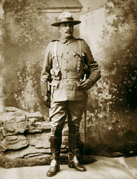
-
Article
Fort Vermilion
Fort Vermilion, Alta, Unincorporated Place, population 727 (2011c), 714 (2006c). Fort Vermilion is located about 70 km east of HIGH LEVEL and is one of the communities of Mackenzie County. The name Fort Vermilion refers to the red ochre found in the area.
"https://d3d0lqu00lnqvz.cloudfront.net/media/media/7b54f899-613a-4dce-8a8b-8e0971b7f4fa.jpg" // resources/views/front/categories/view.blade.php
https://d3d0lqu00lnqvz.cloudfront.net/media/media/7b54f899-613a-4dce-8a8b-8e0971b7f4fa.jpg
-
Article
Forteau
Forteau, NL, incorporated as a town in 1997, population 429 (2011c), 448 (2006c). The Town of Forteau is a fishing and services centre on Forteau Bay in southern Labrador, 25 km across the Strait of Belle Isle from insular Newfoundland.
"https://thecanadianencyclopedia.ca/images/tce_placeholder.jpg?v=e9dca980c9bdb3aa11e832e7ea94f5d9" // resources/views/front/categories/view.blade.php
https://thecanadianencyclopedia.ca/images/tce_placeholder.jpg?v=e9dca980c9bdb3aa11e832e7ea94f5d9
-
Article
Fortune
Fortune, NL, incorporated as a town in 1946, population 1442 (2011c), 1458 (2006c). The Town of Fortune is located on the west end of the Burin Peninsula at the mouth of Fortune Bay.
"https://thecanadianencyclopedia.ca/images/tce_placeholder.jpg?v=e9dca980c9bdb3aa11e832e7ea94f5d9" // resources/views/front/categories/view.blade.php
https://thecanadianencyclopedia.ca/images/tce_placeholder.jpg?v=e9dca980c9bdb3aa11e832e7ea94f5d9
-
Article
Fox Creek
Fox Creek, AB, incorporated as a town in 1967, population 1,639 (2021 census), 1,971 (2016 census). The Town of Fox Creek is located 74 km west of Whitecourt.
"https://thecanadianencyclopedia.ca/images/tce_placeholder.jpg?v=e9dca980c9bdb3aa11e832e7ea94f5d9" // resources/views/front/categories/view.blade.php
https://thecanadianencyclopedia.ca/images/tce_placeholder.jpg?v=e9dca980c9bdb3aa11e832e7ea94f5d9
-
Article
Fredericton
Fredericton, NB, incorporated as a city in 1848, population 58,220 (2016 c), 56,224 (2011 c). The city of Fredericton is the provincial capital and is located in central New Brunswick, just below the head of tide on the Saint John River, 135 km inland from the Bay of Fundy.
"https://d3d0lqu00lnqvz.cloudfront.net/media/media/61e2af78-c031-49ab-b8d2-9e86e8377475.jpg" // resources/views/front/categories/view.blade.php
https://d3d0lqu00lnqvz.cloudfront.net/media/media/61e2af78-c031-49ab-b8d2-9e86e8377475.jpg
-
Article
Fruitvale
Fruitvale, BC, incorporated as a village in 1952, population 2016 (2011c), 1952 (2006c). The Village of Fruitvale is located in the southern interior of BC close to the US border, 11 km east of TRAIL, 645 km east of Vancouver.
"https://d3d0lqu00lnqvz.cloudfront.net/media/media/0f6874e9-2706-4ff6-a872-f66d45e622f8.jpg" // resources/views/front/categories/view.blade.php
https://d3d0lqu00lnqvz.cloudfront.net/media/media/0f6874e9-2706-4ff6-a872-f66d45e622f8.jpg
-
Article
Gagetown
Gagetown, NB, incorporated as a village in 1966, population 698 (2011c), 719 (2006c). The Village of Gagetown is situated on Gagetown Creek, adjacent to the SAINT JOHN RIVER and opposite the mouth of the Jemseg River.
"https://thecanadianencyclopedia.ca/images/tce_placeholder.jpg?v=e9dca980c9bdb3aa11e832e7ea94f5d9" // resources/views/front/categories/view.blade.php
https://thecanadianencyclopedia.ca/images/tce_placeholder.jpg?v=e9dca980c9bdb3aa11e832e7ea94f5d9
-
"https://d3d0lqu00lnqvz.cloudfront.net/1200px-Old_Post_Office_Galt_Cambridge_Ontario.jpg" // resources/views/front/categories/view.blade.php
https://d3d0lqu00lnqvz.cloudfront.net/1200px-Old_Post_Office_Galt_Cambridge_Ontario.jpg
-
Article
Gambo
Gambo, NL, incorporated as a town in 1964, population 1984 (2011c), 2072 (2006c). The Town of Gambo is an amalgamation of three communities - Dark Cove, Middle Brook and Gambo - stretching along the shore at the end of Freshwater Bay, a long indraft of BONAVISTA BAY.
"https://thecanadianencyclopedia.ca/images/tce_placeholder.jpg?v=e9dca980c9bdb3aa11e832e7ea94f5d9" // resources/views/front/categories/view.blade.php
https://thecanadianencyclopedia.ca/images/tce_placeholder.jpg?v=e9dca980c9bdb3aa11e832e7ea94f5d9
-
Article
Gananoque
Gananoque, Ont, incorporated as a town in 1890, population 5194 (2011c), 5285 (2006c). The Town of Gananoque is located at the confluence of the St Lawrence and Gananoque rivers, 29 km east of Kingston.
"https://thecanadianencyclopedia.ca/images/tce_placeholder.jpg?v=e9dca980c9bdb3aa11e832e7ea94f5d9" // resources/views/front/categories/view.blade.php
https://thecanadianencyclopedia.ca/images/tce_placeholder.jpg?v=e9dca980c9bdb3aa11e832e7ea94f5d9
-
Article
Ganges
Ganges, BC, Unincorporated Place. Ganges is the major community centre of SALTSPRING ISLAND, the largest island in the southern GULF ISLANDS chain. Named after HMS Ganges, flagship of the Pacific Station 1857-60, it is located at
"https://thecanadianencyclopedia.ca/images/tce_placeholder.jpg?v=e9dca980c9bdb3aa11e832e7ea94f5d9" // resources/views/front/categories/view.blade.php
https://thecanadianencyclopedia.ca/images/tce_placeholder.jpg?v=e9dca980c9bdb3aa11e832e7ea94f5d9
-
Article
Garson
Garson, Manitoba, unincorporated village, population 483 (2011c), 324 (2006c). Garson was incorporated as the Village of Lyall in 1915 and amalgamated into the Rural Municipality of Brokenhead in 2003. The community is located 37 km northeast of Winnipeg.
"https://thecanadianencyclopedia.ca/images/tce_placeholder.jpg?v=e9dca980c9bdb3aa11e832e7ea94f5d9" // resources/views/front/categories/view.blade.php
https://thecanadianencyclopedia.ca/images/tce_placeholder.jpg?v=e9dca980c9bdb3aa11e832e7ea94f5d9
-
Article
Gaspé
It is one of the oldest settlements in North America: on 24 July 1534, Jacques Cartier took possession of Canada on behalf of the king of France and placed a cross at this location, which very soon became a fishing port and supply centre for New France.
"https://d3d0lqu00lnqvz.cloudfront.net/media/media/bbc9e3a7-9a38-4b2c-848d-b51eba03f1fd.jpg" // resources/views/front/categories/view.blade.php
https://d3d0lqu00lnqvz.cloudfront.net/media/media/bbc9e3a7-9a38-4b2c-848d-b51eba03f1fd.jpg
-
Article
Gastown
Gastown is a retail and commercial district in Vancouver, British Columbia. It is bounded by Cordova Street and the waterfront between Richards Street and Main Street. The original Gastown settlement formed the nucleus for the City of Vancouver and is now a National Historic Site. Today, Gastown is a popular tourist destination and home to restaurants, gift shops, boutiques, galleries, nightclubs and bars. It is also part of the Downtown Eastside, Vancouver’s lowest-income neighbourhood, and the location of single resident occupancy hotels, social housing and social services.
"https://d3d0lqu00lnqvz.cloudfront.net/media/media/de041c94-dd8a-4af8-8def-f3bc4cc26777.jpg" // resources/views/front/categories/view.blade.php
https://d3d0lqu00lnqvz.cloudfront.net/media/media/de041c94-dd8a-4af8-8def-f3bc4cc26777.jpg