
Browse "Cities & Populated Places"
-
Article
Fort Frances
Fort Frances, Ontario, incorporated as a town in 1903, population 7952 (2011c), 8103 (2006c). The Town of Fort Frances is located in northwestern Ontario at the west end of RAINY LAKE, where it drains into Rainy River.
"https://thecanadianencyclopedia.ca/images/tce_placeholder.jpg?v=e9dca980c9bdb3aa11e832e7ea94f5d9" // resources/views/front/categories/view.blade.php
https://thecanadianencyclopedia.ca/images/tce_placeholder.jpg?v=e9dca980c9bdb3aa11e832e7ea94f5d9
-
Article
Fort Good Hope
Fort Good Hope, NWT, incorporated as a charter community in 1995, population 515 (2011c), 557 (2006c).
"https://d3d0lqu00lnqvz.cloudfront.net/media/media/1f4ae5ba-ddad-4d14-bd8f-f108e98c30af.jpg" // resources/views/front/categories/view.blade.php
https://d3d0lqu00lnqvz.cloudfront.net/media/media/1f4ae5ba-ddad-4d14-bd8f-f108e98c30af.jpg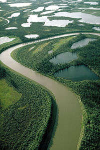
-
Article
Fort Liard
Fort Liard, NWT, incorporated as a hamlet in 1987, population 536 (2011c), 583 (2006c). The Hamlet of Fort Liard is located on the south bank of the Liard River, 544 km by air southwest of Yellowknife and about 25 km north of the BC border.
"https://thecanadianencyclopedia.ca/images/tce_placeholder.jpg?v=e9dca980c9bdb3aa11e832e7ea94f5d9" // resources/views/front/categories/view.blade.php
https://thecanadianencyclopedia.ca/images/tce_placeholder.jpg?v=e9dca980c9bdb3aa11e832e7ea94f5d9
-
Article
Fort Macleod
Fort Macleod, Alberta, incorporated as a town in 1892, population 3,297 (2021 census), 2,967 (2016 census). The town of Fort Macleod is located on the Oldman River, 165 km south of Calgary.
"https://d3d0lqu00lnqvz.cloudfront.net/media/media/f9dc98d5-ab5b-4c22-a263-d93badedcc89.jpg" // resources/views/front/categories/view.blade.php
https://d3d0lqu00lnqvz.cloudfront.net/media/media/f9dc98d5-ab5b-4c22-a263-d93badedcc89.jpg
-
Article
Fort McMurray
Fort McMurray, Alberta, unincorporated population centre, population 61,374 (2011c), 47,705 (2006c). Fort McMurray is the largest community in the Regional Municipality of Wood Buffalo (RMWB). It is technically known as the municipality’s “Urban Service Area” and colloquially known as “Fort Mac.” The community located near the confluence of the Athabasca and Clearwater rivers in northeastern Alberta, near the centre of the vast Athabasca oil sands deposit. Originally incorporated as a city in 1980, in 1995 Fort McMurray merged with much of the surrounding area — collectively known as Improvement District No. 143 — to create the RMWB. At 63,783 km2, the municipality is the largest in North America in terms of size, accounting for nearly 10 per cent of the province’s total area. In May 2016, Fort McMurray experienced one of the worst forest fires in Canadian history. More than 80,000 residents were evacuated and approximately 2,400 structures — about 10 per cent of the city — were destroyed.
"https://d3d0lqu00lnqvz.cloudfront.net/media/media/c51a0711-1d24-48e1-9267-7117eaa2eb47.jpg" // resources/views/front/categories/view.blade.php
https://d3d0lqu00lnqvz.cloudfront.net/media/media/c51a0711-1d24-48e1-9267-7117eaa2eb47.jpg
-
Article
Fort McPherson
Fort McPherson, Northwest Territories, population 647 (2021). The hamlet of Fort McPherson is located on the right bank of the Peel River, on the Dempster Highway. It is west of the Mackenzie River and east of the Richardson Mountains. Fort McPherson is called Teetł’it Zheh (“head of the waters-town”) in Gwich’in, an Athapaskan language (see Indigenous Languages in Canada). The hamlet is home to the Teetł’it Gwich’in First Nation (“people of the headwaters”). Fort McPherson is one of four communities in the Gwich’in Settlement Region. The region is an area created by the Gwich’in Comprehensive Land Claim Agreement (1992). The other three communities in the region are Aklavik, Tsiigehtchic and Inuvik.
"https://d3d0lqu00lnqvz.cloudfront.net/media/new_article_images/FortMcPherson/FortMcPhersonDog.jpg" // resources/views/front/categories/view.blade.php
https://d3d0lqu00lnqvz.cloudfront.net/media/new_article_images/FortMcPherson/FortMcPhersonDog.jpg
-
Article
Fort Nelson
Fort Nelson, BC, population centre, population 2,611 (2021 census), 3,371 (2016 census). Fort Nelson is the service centre for the Northern Rockies Regional Municipality (NRRM). The NRRM is made up of a number of communities, of which Fort Nelson is the largest. Fort Nelson is located in the northeast corner of British Columbia, near the confluence of three rivers: Muskwa, Prophet and Sikanni Chief. Together these rivers combine to become the Fort Nelson River. The community is 387 km north of Fort St. John. It was named after British Admiral Horatio Nelson, famous for the Battle of Trafalgar. Incorporated as a town in 1987, Fort Nelson became a part of the NRRM in 2009.
"https://thecanadianencyclopedia.ca/images/tce_placeholder.jpg?v=e9dca980c9bdb3aa11e832e7ea94f5d9" // resources/views/front/categories/view.blade.php
https://thecanadianencyclopedia.ca/images/tce_placeholder.jpg?v=e9dca980c9bdb3aa11e832e7ea94f5d9
-
Article
Fort Providence
Fort Providence, NWT, incorporated as a hamlet in 1987, population 734 (2011c), 727 (2006c). The Hamlet of Fort Providence is located on the northeast bank of the MACKENZIE RIVER, 233 km southwest of YELLOWKNIFE.
"https://thecanadianencyclopedia.ca/images/tce_placeholder.jpg?v=e9dca980c9bdb3aa11e832e7ea94f5d9" // resources/views/front/categories/view.blade.php
https://thecanadianencyclopedia.ca/images/tce_placeholder.jpg?v=e9dca980c9bdb3aa11e832e7ea94f5d9
-
Article
Fort Qu'Appelle
The Cree and Saulteaux signed Treaty 4 at this site in 1874, and a year later a North-West Mounted Police outpost was established near the present townsite.
"https://d3d0lqu00lnqvz.cloudfront.net/media/media/da0840cf-ea67-4b6e-8a75-62b89d517d96.jpg" // resources/views/front/categories/view.blade.php
https://d3d0lqu00lnqvz.cloudfront.net/media/media/da0840cf-ea67-4b6e-8a75-62b89d517d96.jpg
-
Article
Fort Resolution
Fort Resolution, NWT, incorporated as a hamlet in 2010, population 474 (2011c), 484 (2006c). The Hamlet of Fort Resolution is located on the south shore of GREAT SLAVE LAKE, 153 air km south of Yellowknife.
"https://thecanadianencyclopedia.ca/images/tce_placeholder.jpg?v=e9dca980c9bdb3aa11e832e7ea94f5d9" // resources/views/front/categories/view.blade.php
https://thecanadianencyclopedia.ca/images/tce_placeholder.jpg?v=e9dca980c9bdb3aa11e832e7ea94f5d9
-
Article
Fort Saskatchewan
Fort Saskatchewan, Alberta, incorporated as a city in 1985, population 24,149 (2016 census), 19,051 (2011 census). The city of Fort Saskatchewan is located northeast of Edmonton, on the prairie parklands along to the North Saskatchewan River.
"https://thecanadianencyclopedia.ca/images/tce_placeholder.jpg?v=e9dca980c9bdb3aa11e832e7ea94f5d9" // resources/views/front/categories/view.blade.php
https://thecanadianencyclopedia.ca/images/tce_placeholder.jpg?v=e9dca980c9bdb3aa11e832e7ea94f5d9
-
Article
Fort Simpson
Fort Simpson, Northwest Territories (NWT), incorporated as a village in 1973, population 1,202 (2016 census), 1,238 (2011 census). The Hamlet of Fort Simpson is located on an island at the confluence of the Mackenzie and Liard rivers, 378 air km southwest of Yellowknife.
"https://d3d0lqu00lnqvz.cloudfront.net/media/media/4f133fe0-0529-435c-859e-7fc144a682c6.jpg" // resources/views/front/categories/view.blade.php
https://d3d0lqu00lnqvz.cloudfront.net/media/media/4f133fe0-0529-435c-859e-7fc144a682c6.jpg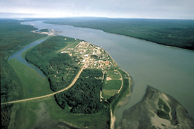
-
Article
Fort Smith
Fort Smith, NWT, incorporated as a town in 1966, population 2093 (2011c), 2364 (2006c). The Town of Fort Smith is located on the southwest bank of the SLAVE RIVER near the Alberta-NWT border, 724 air km north of Edmonton.
"https://d3d0lqu00lnqvz.cloudfront.net/media/media/31cb923e-e098-4941-94b4-9c55de5740ae.jpg" // resources/views/front/categories/view.blade.php
https://d3d0lqu00lnqvz.cloudfront.net/media/media/31cb923e-e098-4941-94b4-9c55de5740ae.jpg
-
Article
Fort St James
Fort St James, BC, incorporated as a village in 1952 and as a district municipality in 1995, population 1691 (2011c), 1350 (2006c). The District of Fort St James is located in central British Columbia on the southeast shore of Stuart Lake, 50 km north of VANDERHOOF.
"https://thecanadianencyclopedia.ca/images/tce_placeholder.jpg?v=e9dca980c9bdb3aa11e832e7ea94f5d9" // resources/views/front/categories/view.blade.php
https://thecanadianencyclopedia.ca/images/tce_placeholder.jpg?v=e9dca980c9bdb3aa11e832e7ea94f5d9
-
Article
Fort St John
Fort St John, BC, incorporated as a city in 1975, population 18 609 (2011c), 17 402 (2006c). The City of Fort St John is located in northeastern British Columbia, about 459 km north of PRINCE GEORGE.
"https://d3d0lqu00lnqvz.cloudfront.net/media/media/3584e5a8-6945-4d72-9f70-ffab17a6c121.jpg" // resources/views/front/categories/view.blade.php
https://d3d0lqu00lnqvz.cloudfront.net/media/media/3584e5a8-6945-4d72-9f70-ffab17a6c121.jpg