
Browse "Cities & Populated Places"
-
Article
Clyde River
Clyde River, Nunavut, incorporated as a hamlet in 1978, population 1,181 (2021 census), 1,053 (2016 census). The Hamlet of Clyde River is located on the west shore of Patricia Bay on the east coast of Baffin Island, 750 km north of Iqaluit. The Inuit name for the community, Kangirqtugaapik, means "a beautiful small cove (or bay)."
"https://d3d0lqu00lnqvz.cloudfront.net/media/media/9974cb6b-fdb8-4408-a0cb-ddcadd23aa9d.jpg" // resources/views/front/categories/view.blade.php
https://d3d0lqu00lnqvz.cloudfront.net/media/media/9974cb6b-fdb8-4408-a0cb-ddcadd23aa9d.jpg
-
Article
Coaldale
Coaldale, Alberta, incorporated as a town in 1952, population 8,215 (2016 census), 7,493 (2011 census). The town of Coaldale is located in southern Alberta, just east of Lethbridge.
"https://thecanadianencyclopedia.ca/images/tce_placeholder.jpg?v=e9dca980c9bdb3aa11e832e7ea94f5d9" // resources/views/front/categories/view.blade.php
https://thecanadianencyclopedia.ca/images/tce_placeholder.jpg?v=e9dca980c9bdb3aa11e832e7ea94f5d9
-
Article
Coaticook
Like most localities in the Eastern Townships, the history of Coaticook starts out in English and ends up in French. The early pioneers were for the most part of American or British origin. The town's founder was Richard Baldwin, Sr, who built a house there in 1830.
"https://d3d0lqu00lnqvz.cloudfront.net/media/media/5337e007-618d-4242-8fa4-c4e30c93c459.jpg" // resources/views/front/categories/view.blade.php
https://d3d0lqu00lnqvz.cloudfront.net/media/media/5337e007-618d-4242-8fa4-c4e30c93c459.jpg
-
Article
Cobalt (Ont)
Cobalt, Ont, incorporated as a town in 1907, population 1133 (2011c), 1224 (2006c). The Town of Cobalt, located about 480 km north of Toronto near the Québec border and Lake Timiskaming, lies between the clay belt to the north around New Liskeard and the heavily forested area of Temagami to the south.
"https://d3d0lqu00lnqvz.cloudfront.net/media/media/f0555ad3-4d10-4288-b3f2-ea1afde0054e.jpg" // resources/views/front/categories/view.blade.php
https://d3d0lqu00lnqvz.cloudfront.net/media/media/f0555ad3-4d10-4288-b3f2-ea1afde0054e.jpg
-
Article
Cobourg
Cobourg, Ont, incorporated as a town in 1837, population 18 519 (2011c), 18 210 (2006c). The Town of Cobourg is located on north shore of Lake Ontario, 112 km east of Toronto.
"https://thecanadianencyclopedia.ca/images/tce_placeholder.jpg?v=e9dca980c9bdb3aa11e832e7ea94f5d9" // resources/views/front/categories/view.blade.php
https://thecanadianencyclopedia.ca/images/tce_placeholder.jpg?v=e9dca980c9bdb3aa11e832e7ea94f5d9
-
Article
Cochrane (Alta)
Cochrane, Alta, incorporated as a town in 1971, population 17 580 (2011c), 13 760 (2006c). The Town of Cochrane is located 35 km northwest of Calgary, on the BOW RIVER. It is named for Senator Matthew H.
"https://thecanadianencyclopedia.ca/images/tce_placeholder.jpg?v=e9dca980c9bdb3aa11e832e7ea94f5d9" // resources/views/front/categories/view.blade.php
https://thecanadianencyclopedia.ca/images/tce_placeholder.jpg?v=e9dca980c9bdb3aa11e832e7ea94f5d9
-
Article
Cold Lake
Cold Lake, Alberta, incorporated as a city in 2000, population 15, 661 (2021 census), 14,976 (2016 census). The city of Cold Lake is located on a lake of the same name, 290 km northeast of Edmonton. The Cree called the lake “Kinosoo” or “big fish” after a Cree legend. European settlers named the lake for its deep, cold water.
"https://d3d0lqu00lnqvz.cloudfront.net/media/media/9a26c61d-d249-4e98-9fe3-21c0199423c0.jpg" // resources/views/front/categories/view.blade.php
https://d3d0lqu00lnqvz.cloudfront.net/media/media/9a26c61d-d249-4e98-9fe3-21c0199423c0.jpg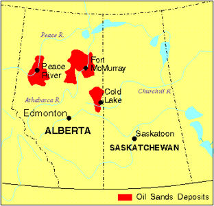
-
Article
Coldstream
Coldstream, BC, incorporated as a district municipality in 1906, population 10 314 (2011c), 9471 (2006c). The District of Coldstream lies in the valley of Coldstream Creek, about two kilometres southeast of VERNON. Captain Charles F.
"https://thecanadianencyclopedia.ca/images/tce_placeholder.jpg?v=e9dca980c9bdb3aa11e832e7ea94f5d9" // resources/views/front/categories/view.blade.php
https://thecanadianencyclopedia.ca/images/tce_placeholder.jpg?v=e9dca980c9bdb3aa11e832e7ea94f5d9
-
Article
Collingwood
Collingwood, Ont, incorporated as a town in 1858, population 19 241 (2011c), 17 290 (2006c). The Town of Collingwood is located on Nottawasaga Bay at the southern end of Georgian Bay, 55 km northwest of Barrie.
"https://thecanadianencyclopedia.ca/images/tce_placeholder.jpg?v=e9dca980c9bdb3aa11e832e7ea94f5d9" // resources/views/front/categories/view.blade.php
https://thecanadianencyclopedia.ca/images/tce_placeholder.jpg?v=e9dca980c9bdb3aa11e832e7ea94f5d9
-
Article
Colwood
Colwood, BC, incorporated as a city in 1985, population 16 093 (2011c), 14 687 (2006c). The City of Colwood is part of Greater Victoria and located ten kilometres west of downtown VICTORIA. Colwood takes its name from the farm run by Captain Edward E.
"https://d3d0lqu00lnqvz.cloudfront.net/media/media/f9d724d8-4cdb-41f1-a12e-cbff359501cd.jpg" // resources/views/front/categories/view.blade.php
https://d3d0lqu00lnqvz.cloudfront.net/media/media/f9d724d8-4cdb-41f1-a12e-cbff359501cd.jpg
-
Article
Come by Chance
Come By Chance, Newfoundland and Labrador, incorporated as a town in 1969, population 208 (2021 census), 228 (2016 census). The town of Come by Chance is located at the head of Placentia Bay on the Isthmus of Avalon.
"https://d3d0lqu00lnqvz.cloudfront.net/media/media/29533281-0a15-48be-ab25-8c86277c7732.jpg" // resources/views/front/categories/view.blade.php
https://d3d0lqu00lnqvz.cloudfront.net/media/media/29533281-0a15-48be-ab25-8c86277c7732.jpg
-
Article
Conception Bay South
Conception Bay South, NL, incorporated as a town in 1973, population 24 848 (2011c), 21 966 (2006c). The town of Conception Bay South is located on the southeast shore of Conception Bay on the Avalon Peninsula.
"https://thecanadianencyclopedia.ca/images/tce_placeholder.jpg?v=e9dca980c9bdb3aa11e832e7ea94f5d9" // resources/views/front/categories/view.blade.php
https://thecanadianencyclopedia.ca/images/tce_placeholder.jpg?v=e9dca980c9bdb3aa11e832e7ea94f5d9
-
Article
Contrecoeur
Contrecoeur was one of the first French establishments in North America. It was founded as the seigneurie de Contrecoeur in 1667 by Sieur Antoine Pécaudy de Contrecoeur, captain of the Carignan-Salières regiment. Antoine Pécaudy de Contrecoeur was born in 1596, at Vignieu en Dauphiné, France.
"https://d3d0lqu00lnqvz.cloudfront.net/media/media/d23eab8c-4936-4d32-86d2-e499a33db129.jpg" // resources/views/front/categories/view.blade.php
https://d3d0lqu00lnqvz.cloudfront.net/media/media/d23eab8c-4936-4d32-86d2-e499a33db129.jpg
-
Article
Coquitlam
Coquitlam, British Columbia, incorporated as a city in 1992, population 148,625 (2021 census), 139,284 (2016 census). The city of Coquitlam is located on the north bank of the Fraser River between Burnaby and New Westminster to the west and Port Coquitlam and Pitt Meadows to the east. Northwest and northeast Coquitlam include the lower slopes of the Eagle and Burke Mountains, with peaks up to 1,600 m high.
"https://d3d0lqu00lnqvz.cloudfront.net/media/media/a758c067-dbf4-4c5a-82b3-fe11995f583c.jpg" // resources/views/front/categories/view.blade.php
https://d3d0lqu00lnqvz.cloudfront.net/media/media/a758c067-dbf4-4c5a-82b3-fe11995f583c.jpg
-
Article
Coral Harbour
Coral Harbour, Nunavut, incorporated as a hamlet in 1972, population 891 (2016 census), 834 (2011 census). The hamlet of Coral Harbour is located at the head of South Bay on Southampton Island in Hudson Bay, 715 km southeast of Iqaluit. The name Coral Harbour is descriptive and refers to the fossilized coral in its harbour. The Inuit’s traditional name for the site and the island, Salliq, is also descriptive and means “flat island.”
"https://thecanadianencyclopedia.ca/images/tce_placeholder.jpg?v=e9dca980c9bdb3aa11e832e7ea94f5d9" // resources/views/front/categories/view.blade.php
https://thecanadianencyclopedia.ca/images/tce_placeholder.jpg?v=e9dca980c9bdb3aa11e832e7ea94f5d9