
Browse "Places"
-
Article
Grise Fiord
Grise Fiord, Nunavut, incorporated as a hamlet in 1987, population 144 (2021 census), 129 (2016 census).
"https://d3d0lqu00lnqvz.cloudfront.net/media/media/Grise-Fiord/View_of_Grise_Fiord.jpg" // resources/views/front/categories/view.blade.php
https://d3d0lqu00lnqvz.cloudfront.net/media/media/Grise-Fiord/View_of_Grise_Fiord.jpg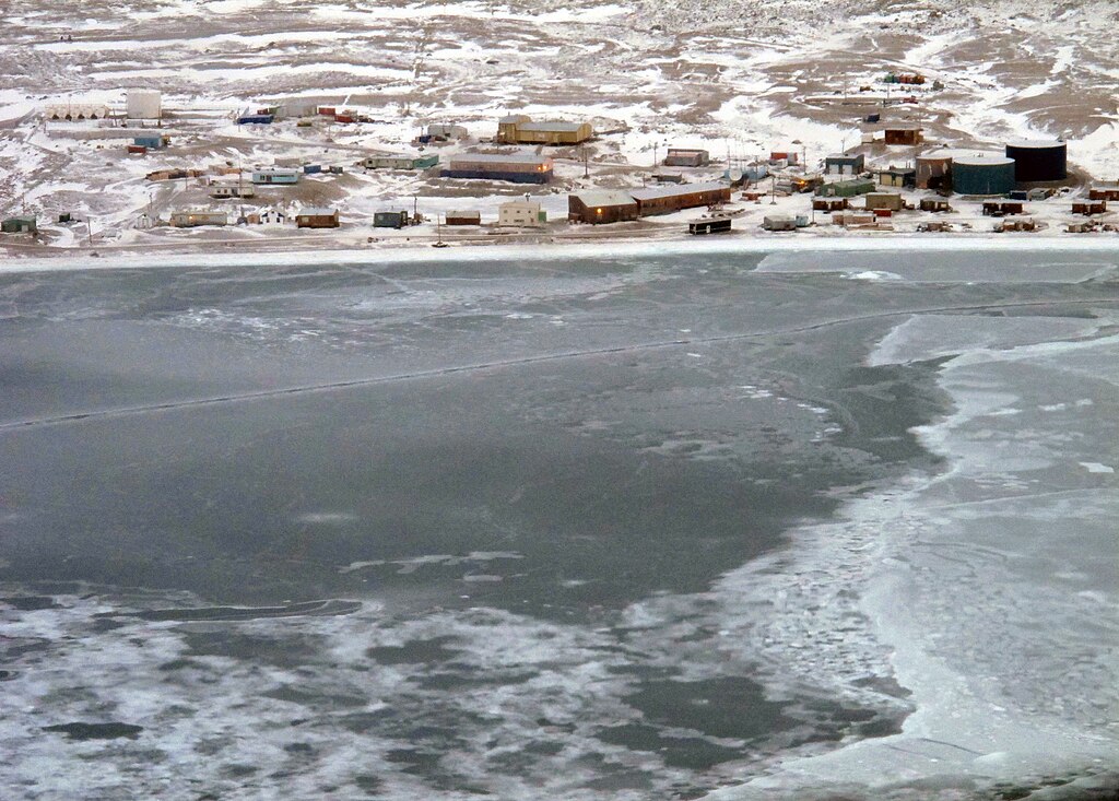
-
Article
Gros Morne National Park
In 1970, an agreement was signed to establish Gros Morne National Park (1805 km2) on the west coast of Newfoundland. In 1987 Gros Morne National Park was designated a United Nations World Heritage Site because of its glacial and geologic history.
"https://d3d0lqu00lnqvz.cloudfront.net/media/media/efe7172c-e877-4f96-a652-0d67fdf65947.jpg" // resources/views/front/categories/view.blade.php
https://d3d0lqu00lnqvz.cloudfront.net/media/media/efe7172c-e877-4f96-a652-0d67fdf65947.jpg
-
Article
Grouard
Grouard, Alberta, Unincorporated Place. Grouard, incorporated as a town in 1913 but dissolved in 1944, is located at the west end of Lesser Slave Lake, about 35 km northeast of High Prairie. St. Bernard Mission's church and cemetery in Grouard are recognized as a historic place.
"https://d3d0lqu00lnqvz.cloudfront.net/media/media/8371fe6e-0381-4408-9f87-a3d353442ccc.jpg" // resources/views/front/categories/view.blade.php
https://d3d0lqu00lnqvz.cloudfront.net/media/media/8371fe6e-0381-4408-9f87-a3d353442ccc.jpg
-
Article
Guelph
Guelph, Ontario, incorporated as a city in 1879, population 143,740 (2021 census), 131,794 (2016 census). The City of Guelph, the seat of Wellington County, is located on the Speed River in south central Ontario, 96 km west of Toronto and 28 km east of Kitchener-Waterloo. This industrial and educational centre is set in the heart of a highly productive agricultural region.
"https://d3d0lqu00lnqvz.cloudfront.net/guelph/mapjpg.jpg" // resources/views/front/categories/view.blade.php
https://d3d0lqu00lnqvz.cloudfront.net/guelph/mapjpg.jpg
-
Article
Music in Guelph
Guelph, Ont. Founded 1827 by John Galt in the heart of agricultural Ontario and incorporated in 1879. In 1846 there were 1240 people living in Guelph. By 1988 the population had reached 80,786 including a large Italian.community.
"https://thecanadianencyclopedia.ca/images/tce_placeholder.jpg?v=e9dca980c9bdb3aa11e832e7ea94f5d9" // resources/views/front/categories/view.blade.php
https://thecanadianencyclopedia.ca/images/tce_placeholder.jpg?v=e9dca980c9bdb3aa11e832e7ea94f5d9
-
Article
Gulf
A gulf is a body of water partly surrounded by land and connected to an ocean or sea. This connection sometimes takes the form of a narrow passage called a strait. The nomenclature of water inlets can be inconsistent between sources. Sometimes, the terms gulf, bay and sea are used interchangeably. For example, the Arabian Sea and Hudson Bay can both be classified as gulfs. However, in most cases a gulf is deeper and larger than a bay and is also more enclosed from the ocean or sea to which it is connected. Because gulfs are partially surrounded by land, their waters are typically calmer than those of oceans. This makes them suitable for activities such as transportation, fishing and leisure.
"https://d3d0lqu00lnqvz.cloudfront.net/media/new_article_images/Gulf/GulfofStLawrence.jpg" // resources/views/front/categories/view.blade.php
https://d3d0lqu00lnqvz.cloudfront.net/media/new_article_images/Gulf/GulfofStLawrence.jpg
-
Article
Gulf Islands
Their bucolic charm, calm waters, rich bird and marine life and mild climate, in the driest zone on Canada's Pacific coast, have attracted homesteaders and cottagers since about 1859. Stands of tall timber growing in deep soil were logged early in this century.
"https://d3d0lqu00lnqvz.cloudfront.net/media/media/2eb4a133-4037-49ab-af23-cc43cde9708f.jpg" // resources/views/front/categories/view.blade.php
https://d3d0lqu00lnqvz.cloudfront.net/media/media/2eb4a133-4037-49ab-af23-cc43cde9708f.jpg
-
Article
Gulf Islands National Park Reserve
Gulf Islands National Park Reserve is located in the southern Gulf Islands between Vancouver Island and the BC mainland. Created in 2003 and formally established in 2010, the park encompasses 36 km2 of land and 26 km2 of adjacent waters.
"https://d3d0lqu00lnqvz.cloudfront.net/media/media/b6ad5290-ef67-42ea-b426-b83ffb3ceca7.jpg" // resources/views/front/categories/view.blade.php
https://d3d0lqu00lnqvz.cloudfront.net/media/media/b6ad5290-ef67-42ea-b426-b83ffb3ceca7.jpg
-
Article
Gulf of Boothia
The Gulf of Boothia is entered through Prince Regent Inlet. To the east it is bounded by the northwest coast of Baffin Island, and to the west by the Boothia Peninsula. Depths are generally about 275 m, decreasing southward.
"https://thecanadianencyclopedia.ca/images/tce_placeholder.jpg?v=e9dca980c9bdb3aa11e832e7ea94f5d9" // resources/views/front/categories/view.blade.php
https://thecanadianencyclopedia.ca/images/tce_placeholder.jpg?v=e9dca980c9bdb3aa11e832e7ea94f5d9
-
Article
Gulf of St Lawrence
The Gulf of St Lawrence, a large (250,000 km2), roughly triangular inland sea receiving on average 10,100 m3/s of fresh water from the St. Lawrence River at its northwest apex, is connected to the Atlantic by the Strait of Belle Isle at the northeast and Cabot Strait at the southeast corners.
"https://d3d0lqu00lnqvz.cloudfront.net/gulfofstlawrence/Gulf-of-St-Lawrence.jpg" // resources/views/front/categories/view.blade.php
https://d3d0lqu00lnqvz.cloudfront.net/gulfofstlawrence/Gulf-of-St-Lawrence.jpg
-
Article
Guysborough
Guysborough, NS, Community, population 403 (2011c), 428 (2006c). Guysborough, the shire town of Guysborough County, is located on the east shore of mainland Nova Scotia on Chedabucto Bay, 51 km from the Canso Causeway.
"https://thecanadianencyclopedia.ca/images/tce_placeholder.jpg?v=e9dca980c9bdb3aa11e832e7ea94f5d9" // resources/views/front/categories/view.blade.php
https://thecanadianencyclopedia.ca/images/tce_placeholder.jpg?v=e9dca980c9bdb3aa11e832e7ea94f5d9
-
Article
Gwaii Haanas
At 1,470 km2, Gwaii Haanas National Park Reserve, National Marine Conservation Area Reserve, and Haida Heritage Site (also known as Gwaii Haanas) encompasses 15 per cent of Haida Gwaii — a group of islands off the coast of British Columbia, and the ancestral territory of the Haida people. Gwaii Haanas includes over 138 of the approximately 150 islands that make up Haida Gwaii (which were temporarily known as the Queen Charlotte Islands). In the Haida language, Gwaii Haanas means “islands of beauty.”
"https://d3d0lqu00lnqvz.cloudfront.net/media/media/77c96547-25d5-4295-a540-5a07340acb6c.jpg" // resources/views/front/categories/view.blade.php
https://d3d0lqu00lnqvz.cloudfront.net/media/media/77c96547-25d5-4295-a540-5a07340acb6c.jpg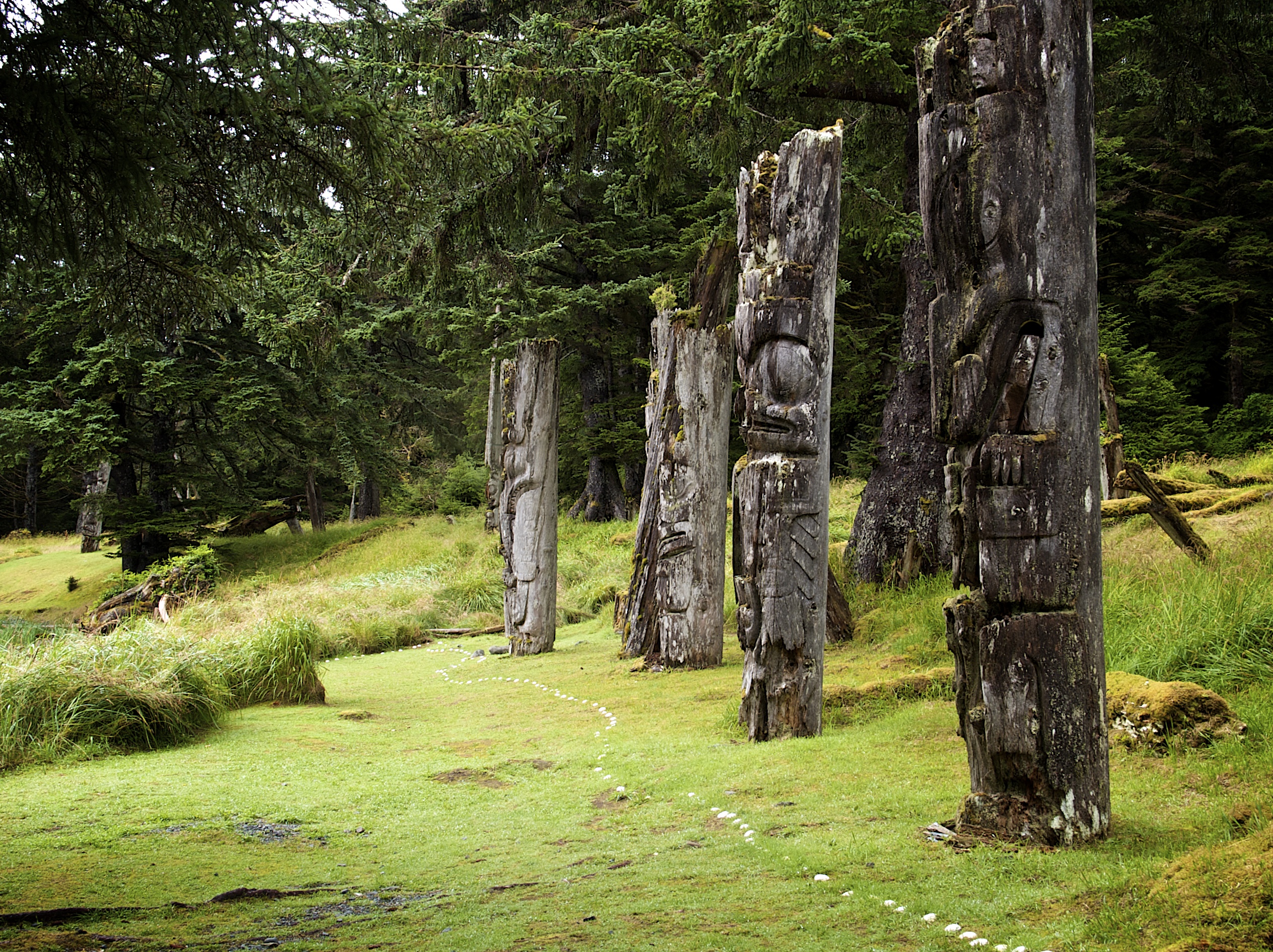
-
Editorial
Habitants and French-Speaking Quebec
The following article is an editorial written by The Canadian Encyclopedia staff. Editorials are not usually updated. Habitants were once a symbol of French-speaking Quebec, in much the same way that cowboys became an iconic image of the American West and gauchos a symbol of Argentina. In the word’s most familiar meaning, going back to the late 17th century, a habitant was a farmer who worked and lived on a plot of land granted him by a wealthy seigneur (see Seigneurial System). Although the system of land tenure in Quebec changed in the wake of the British Conquest, for many decades afterwards the notion of a habitant remained crucial to the perceived identity of the province.
"https://d3d0lqu00lnqvz.cloudfront.net/media/new_article_images/HabitantandQuebec/0967.jpg" // resources/views/front/categories/view.blade.php
https://d3d0lqu00lnqvz.cloudfront.net/media/new_article_images/HabitantandQuebec/0967.jpg
-
Article
Habitat 67
Habitat 67 is an experimental urban residential complex designed by Israeli-born architect Moshe Safdie and located in the Cité du Havre neighbourhood south of Montréal’s Old Port sector. Commissioned by the Canadian Corporation for Expo 67, the project derives its name from the theme of the fair, “Man and His World,” and became one of the major pavilions of the exhibition. It is the only remaining structure from Expo 67 to retain its original function. In 2015, the Guardian called Habitat “a functioning icon of 1960s utopianism, and one of that period’s most important buildings.”
"https://d3d0lqu00lnqvz.cloudfront.net/media/new_article_images/Habitat67/d378c1fa-9a6d-400c-aa2b-eb5b8351d306.jpg" // resources/views/front/categories/view.blade.php
https://d3d0lqu00lnqvz.cloudfront.net/media/new_article_images/Habitat67/d378c1fa-9a6d-400c-aa2b-eb5b8351d306.jpg
-
Article
Haida Gwaii
The Haida Gwaii is a group of islands off the north coast of British Columbia. The name means "Islands of the People" in the language of the Haida, who claim the archipelago as their ancestral lands. Captain George Dixon named this group of islands the Queen Charlotte Islands in 1787 after one of his ships, which in turn was named for the wife of King George III. This was its official name until 2010, when Haida Gwaii was accepted. In 2024 and 2025, leaders from both the Haida Nation and the British Columbia and federal governments attended ceremonies to cement a title agreement which returned the crown land on the Haida Gwaii islands to the Haida Nation.
"https://d3d0lqu00lnqvz.cloudfront.net/media/media/440414f5-caff-4536-9eac-90dceba5603d.jpg" // resources/views/front/categories/view.blade.php
https://d3d0lqu00lnqvz.cloudfront.net/media/media/440414f5-caff-4536-9eac-90dceba5603d.jpg