
Browse "Places"
-
Article
Forteau
Forteau, NL, incorporated as a town in 1997, population 429 (2011c), 448 (2006c). The Town of Forteau is a fishing and services centre on Forteau Bay in southern Labrador, 25 km across the Strait of Belle Isle from insular Newfoundland.
"https://thecanadianencyclopedia.ca/images/tce_placeholder.jpg?v=e9dca980c9bdb3aa11e832e7ea94f5d9" // resources/views/front/categories/view.blade.php
https://thecanadianencyclopedia.ca/images/tce_placeholder.jpg?v=e9dca980c9bdb3aa11e832e7ea94f5d9
-
Article
Fortification
Although the barrier posed by these walls was sometimes increased by setting a ditch below their outer faces, fortification did not progress beyond this rather simple conception until the 16th century.
"https://d3d0lqu00lnqvz.cloudfront.net/media/media/528fc0db-255d-4206-bfde-3fcb0b932747.jpg" // resources/views/front/categories/view.blade.php
https://d3d0lqu00lnqvz.cloudfront.net/media/media/528fc0db-255d-4206-bfde-3fcb0b932747.jpg
-
Article
Fortune
Fortune, NL, incorporated as a town in 1946, population 1442 (2011c), 1458 (2006c). The Town of Fortune is located on the west end of the Burin Peninsula at the mouth of Fortune Bay.
"https://thecanadianencyclopedia.ca/images/tce_placeholder.jpg?v=e9dca980c9bdb3aa11e832e7ea94f5d9" // resources/views/front/categories/view.blade.php
https://thecanadianencyclopedia.ca/images/tce_placeholder.jpg?v=e9dca980c9bdb3aa11e832e7ea94f5d9
-
Article
Forum
Forum. Montreal arena, home of the famous hockey team the Canadiens, and the site of many sporting, musical, and stage events. Situated at the corner of Atwater and Ste-Catherine streets, it is the property of the Canadian Arena Co.
"https://thecanadianencyclopedia.ca/images/tce_placeholder.jpg?v=e9dca980c9bdb3aa11e832e7ea94f5d9" // resources/views/front/categories/view.blade.php
https://thecanadianencyclopedia.ca/images/tce_placeholder.jpg?v=e9dca980c9bdb3aa11e832e7ea94f5d9
-
Article
Fosheim Peninsula
The Fosheim Peninsula is located on the west coast of central Ellesmere Island, Nunavut.
"https://d3d0lqu00lnqvz.cloudfront.net/media/media/99c8f8a7-e4a8-4cab-85df-fa919f71879c.JPG" // resources/views/front/categories/view.blade.php
https://d3d0lqu00lnqvz.cloudfront.net/media/media/99c8f8a7-e4a8-4cab-85df-fa919f71879c.JPG
-
Article
Four Seasons Centre for the Performing Arts
Four Seasons Centre for the Performing Arts. Toronto opera house, situated at the southeast corner of Queen St West and University Avenue.
"https://d3d0lqu00lnqvz.cloudfront.net/media/media/f04c623d-d93a-4bb8-b3cc-b58f90a65d1a.jpg" // resources/views/front/categories/view.blade.php
https://d3d0lqu00lnqvz.cloudfront.net/media/media/f04c623d-d93a-4bb8-b3cc-b58f90a65d1a.jpg
-
Article
Fox Creek
Fox Creek, AB, incorporated as a town in 1967, population 1,639 (2021 census), 1,971 (2016 census). The Town of Fox Creek is located 74 km west of Whitecourt.
"https://thecanadianencyclopedia.ca/images/tce_placeholder.jpg?v=e9dca980c9bdb3aa11e832e7ea94f5d9" // resources/views/front/categories/view.blade.php
https://thecanadianencyclopedia.ca/images/tce_placeholder.jpg?v=e9dca980c9bdb3aa11e832e7ea94f5d9
-
Article
Foxe Basin
Foxe Basin is bordered on its eastern and northern sides by the coast of Baffin Island and in the west by the Melville Peninsula.
"https://thecanadianencyclopedia.ca/images/tce_placeholder.jpg?v=e9dca980c9bdb3aa11e832e7ea94f5d9" // resources/views/front/categories/view.blade.php
https://thecanadianencyclopedia.ca/images/tce_placeholder.jpg?v=e9dca980c9bdb3aa11e832e7ea94f5d9
-
Article
Francis Winspear Centre for Music
The tall, rectangular "performance chamber" is shaped in the traditional "shoebox" design found in some of the most renowned 19th-century European halls, such as the Tonhalle in Zurich, the Concertgebouw in Amsterdam and the Musikvereinsaal in Vienna.
"https://d3d0lqu00lnqvz.cloudfront.net/media/media/c5a96f65-d243-4149-8e5f-fe841e9d28ce.jpg" // resources/views/front/categories/view.blade.php
https://d3d0lqu00lnqvz.cloudfront.net/media/media/c5a96f65-d243-4149-8e5f-fe841e9d28ce.jpg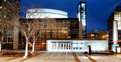
-
Article
Francis Winspear Centre for Music
Funding and DevelopmentIn 1983 a feasibility committee confirmed the need for a new concert hall for the Edmonton Symphony Orchestra, and the same year the Edmonton Concert Hall Foundation was formed under president David Norwood.
"https://d3d0lqu00lnqvz.cloudfront.net/media/media/c5a96f65-d243-4149-8e5f-fe841e9d28ce.jpg" // resources/views/front/categories/view.blade.php
https://d3d0lqu00lnqvz.cloudfront.net/media/media/c5a96f65-d243-4149-8e5f-fe841e9d28ce.jpg
-
Article
Francophones of Saskatchewan (Fransaskois)
The Fransaskois are francophones living in Saskatchewan. According to the 2021 Canadian census, 1.5 per cent of the population (16,850 inhabitants) have French as their mother tongue and 1.1 per cent of the population (12,243 inhabitants) have French as their first official language. (See French language in Canada.)
"https://d3d0lqu00lnqvz.cloudfront.net/media/new_article_images/Fransaskois/Flag_Francophones_Saskatchewan_Fransaskois.png" // resources/views/front/categories/view.blade.php
https://d3d0lqu00lnqvz.cloudfront.net/media/new_article_images/Fransaskois/Flag_Francophones_Saskatchewan_Fransaskois.png
-
Article
Frank Slide Interpretive Centre
The Frank Slide Interpretive Centre is located on the site of the FRANK SLIDE, in the municipality of CROWSNEST PASS, Alta. On 29 April 1903 part of Turtle Mountain broke away and slid through part of the mining community of Frank. There is still considerable controversy over the cause of the slide.
"https://thecanadianencyclopedia.ca/images/tce_placeholder.jpg?v=e9dca980c9bdb3aa11e832e7ea94f5d9" // resources/views/front/categories/view.blade.php
https://thecanadianencyclopedia.ca/images/tce_placeholder.jpg?v=e9dca980c9bdb3aa11e832e7ea94f5d9
-
Article
Fraser River
The Fraser River is the longest river in British Columbia, stretching 1,375 km. It begins on the western side of the Rocky Mountains at Mount Robson Provincial Park, and ends in the Strait of Georgia at Vancouver. Named for explorer Simon Fraser, the river was a transportation route and source of food for the Indigenous people of the region long before Fraser travelled its waters. In 1858, gold was discovered on sandbars south of Yale, setting off the Fraser River Gold rush.
"https://d3d0lqu00lnqvz.cloudfront.net/media/new_article_images/GeographyOfBC/FraserRiverCanyon.jpg" // resources/views/front/categories/view.blade.php
https://d3d0lqu00lnqvz.cloudfront.net/media/new_article_images/GeographyOfBC/FraserRiverCanyon.jpg
-
Article
Fraser River Canyon
The Fraser River Canyon was formed during the Miocene period (22.9-5.33 million years ago) when the river cut down into the uplifting southern part of the Interior Plateau of British Columbia. The canyon characteristics of this
"https://d3d0lqu00lnqvz.cloudfront.net/media/media/49e5b82d-d0a2-4ca6-aa37-99ecf1243a3d.jpg" // resources/views/front/categories/view.blade.php
https://d3d0lqu00lnqvz.cloudfront.net/media/media/49e5b82d-d0a2-4ca6-aa37-99ecf1243a3d.jpg
-
Article
Fraser River Gold Rush
In 1858, around 30,000 gold seekers flooded the banks of the Fraser River from Hope to just north of Lillooet in British Columbia’s first significant gold rush. Although it dissipated by the mid-1860s, the Fraser River Gold Rush had a significant impact on the area’s Indigenous peoples and resulted in the Fraser Canyon War. Fears that the massive influx of American miners would lead the United States to annex the non-sovereign British territory known as New Caledonia also resulted in the founding of British Columbia as a colony on 2 August 1858 (see The Fraser River Gold Rush and the Founding of British Columbia). By the mid-1860s, the Fraser Rush collapsed, and British Columbia sank into a recession.
"https://d3d0lqu00lnqvz.cloudfront.net/media/new_article_images/FraserCanyonWar/Fraser Canyon near Chapmans Bar, Daniel Marshall(1).jpg" // resources/views/front/categories/view.blade.php
https://d3d0lqu00lnqvz.cloudfront.net/media/new_article_images/FraserCanyonWar/Fraser Canyon near Chapmans Bar, Daniel Marshall(1).jpg.jpg)