
Browse "Places"
-
Article
Dorval
Dorval was a farming community and a resort area until the outset of the Second World War. In 1941 it became the home of the FERRY COMMAND and of a military airport, today's Montréal International Airport. After the war, this airport was an economic magnet.
"https://thecanadianencyclopedia.ca/images/tce_placeholder.jpg?v=e9dca980c9bdb3aa11e832e7ea94f5d9" // resources/views/front/categories/view.blade.php
https://thecanadianencyclopedia.ca/images/tce_placeholder.jpg?v=e9dca980c9bdb3aa11e832e7ea94f5d9
-
Article
Douglastown
Douglastown, NB, is an urban community within the city of MIRAMICHI located on the north bank of the MIRAMICHI RIVER.
"https://thecanadianencyclopedia.ca/images/tce_placeholder.jpg?v=e9dca980c9bdb3aa11e832e7ea94f5d9" // resources/views/front/categories/view.blade.php
https://thecanadianencyclopedia.ca/images/tce_placeholder.jpg?v=e9dca980c9bdb3aa11e832e7ea94f5d9
-
Article
Drainage Basin
A drainage basin is an area of land that contributes the water it receives as precipitation to a river or network of rivers.
"https://thecanadianencyclopedia.ca/images/tce_placeholder.jpg?v=e9dca980c9bdb3aa11e832e7ea94f5d9" // resources/views/front/categories/view.blade.php
https://thecanadianencyclopedia.ca/images/tce_placeholder.jpg?v=e9dca980c9bdb3aa11e832e7ea94f5d9
-
Article
Dresden
Dresden, Ontario, population centre, population 2,401 (2021 census), 2,451 (2016 census). Incorporated as a town in 1882, Dresden lost this status in 1998 after it merged into the new municipality of Chatham-Kent. Dresden is an agricultural community located in southwestern Ontario on the Sydenham River. The Dawn Settlement, near Dresden, was one of the final destinations of the Underground Railroad. In the mid-20th century, some businesses in Dresden became infamous for refusing to serve Black Canadians (see Racial Segregation of Black People).
"https://d3d0lqu00lnqvz.cloudfront.net/media/media/83ab1e40-ef36-47fc-9c13-ddd047b6aae7.jpg" // resources/views/front/categories/view.blade.php
https://d3d0lqu00lnqvz.cloudfront.net/media/media/83ab1e40-ef36-47fc-9c13-ddd047b6aae7.jpg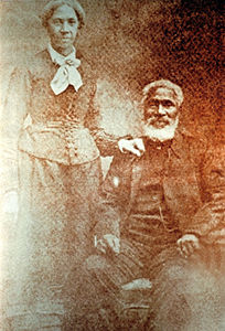
-
Editorial
Drought in Palliser's Triangle
The following article is an editorial written by The Canadian Encyclopedia staff. Editorials are not usually updated.
"https://thecanadianencyclopedia.ca/images/tce_placeholder.jpg?v=e9dca980c9bdb3aa11e832e7ea94f5d9" // resources/views/front/categories/view.blade.php
https://thecanadianencyclopedia.ca/images/tce_placeholder.jpg?v=e9dca980c9bdb3aa11e832e7ea94f5d9
-
Article
Droulers-Tsiionhiakwatha Archaeological Site
The Droulers-Tsiionhiakwatha archaeological site is located in extreme southwest Québec, in Saint-Anicet in the Haut-Saint-Laurent area.
"https://d3d0lqu00lnqvz.cloudfront.net/media/media/9a4f5824-4fef-4ee0-8b04-92257d768832.jpg" // resources/views/front/categories/view.blade.php
https://d3d0lqu00lnqvz.cloudfront.net/media/media/9a4f5824-4fef-4ee0-8b04-92257d768832.jpg
-
Article
Drumheller
Drumheller, Alberta, incorporated as a town in 1998, population 7,909 (2021 census), 7,982 (2016 census). The town of Drumheller is located on the Red Deer River in southern Alberta, 138 km northeast of Calgary. The Red Deer River valley is internationally known its abundance of fossils, particularly of dinosaurs.
"https://thecanadianencyclopedia.ca/images/tce_placeholder.jpg?v=e9dca980c9bdb3aa11e832e7ea94f5d9" // resources/views/front/categories/view.blade.php
https://thecanadianencyclopedia.ca/images/tce_placeholder.jpg?v=e9dca980c9bdb3aa11e832e7ea94f5d9
-
Article
Drummondville
Drummondville, Quebec, incorporated as a city in 1875, population 79,258 (2021 census), 75,423 (2016 census). Drummondville is located on the Saint-François River, a tributary of the St. Lawrence River, in the St. Lawrence Lowland. At the crossroads between highways 20 and 55, between 75 km and 150 km of Montreal, Quebec City, Trois-Rivières and Sherbrooke, it is also known as the “Coeur-du-Québec” (the Heart of Quebec.)
"https://thecanadianencyclopedia.ca/images/tce_placeholder.jpg?v=e9dca980c9bdb3aa11e832e7ea94f5d9" // resources/views/front/categories/view.blade.php
https://thecanadianencyclopedia.ca/images/tce_placeholder.jpg?v=e9dca980c9bdb3aa11e832e7ea94f5d9
-
Article
Dryden
Dryden, Ontario, incorporated as a city in the Kenora District in 1998, population 7,388 (2021 census), 7,749 (2016 census). The City of Dryden is situated on Wabigoon Lake in northwest Ontario, 340 km northwest of Thunder Bay.
"https://thecanadianencyclopedia.ca/images/tce_placeholder.jpg?v=e9dca980c9bdb3aa11e832e7ea94f5d9" // resources/views/front/categories/view.blade.php
https://thecanadianencyclopedia.ca/images/tce_placeholder.jpg?v=e9dca980c9bdb3aa11e832e7ea94f5d9
-
Article
Dubawnt Lake
Dubawnt Lake, 3833 km2, elevation 236 m, is situated in the southern part of mainland Nunavut, 350 km south of the Arctic Circle. Within the Precambrian SHIELD, the lake has irregular shorelines and numerous islands.
"https://thecanadianencyclopedia.ca/images/tce_placeholder.jpg?v=e9dca980c9bdb3aa11e832e7ea94f5d9" // resources/views/front/categories/view.blade.php
https://thecanadianencyclopedia.ca/images/tce_placeholder.jpg?v=e9dca980c9bdb3aa11e832e7ea94f5d9
-
Article
Dubawnt River
Dubawnt River, 842 km long, rises from a web of lakes in the Northwest Territories, 120 km northeast of Lake Athabasca, flows northeast, gathering the waters of Wholdaia, Boyd, Barlow, Nicholson, Dubawnt, Wharton and Marjorie lakes, and turns abruptly northwest to join the Thelon River at Beverly Lake.
"https://thecanadianencyclopedia.ca/images/tce_placeholder.jpg?v=e9dca980c9bdb3aa11e832e7ea94f5d9" // resources/views/front/categories/view.blade.php
https://thecanadianencyclopedia.ca/images/tce_placeholder.jpg?v=e9dca980c9bdb3aa11e832e7ea94f5d9
-
"https://thecanadianencyclopedia.ca/images/tce_placeholder.jpg?v=e9dca980c9bdb3aa11e832e7ea94f5d9" // resources/views/front/categories/view.blade.php
https://thecanadianencyclopedia.ca/images/tce_placeholder.jpg?v=e9dca980c9bdb3aa11e832e7ea94f5d9
-
Article
Dundas
Dundas, Ont, Urban Community within the city of Hamilton. Dundas is located at the west end of Lake Ontario and is situated between 2 faces of the Niagara Escarpment.
"https://d3d0lqu00lnqvz.cloudfront.net/media/media/16ee164e-d06a-4543-9a83-163fa2ae8aa4.jpg" // resources/views/front/categories/view.blade.php
https://d3d0lqu00lnqvz.cloudfront.net/media/media/16ee164e-d06a-4543-9a83-163fa2ae8aa4.jpg
-
Article
Dunnville
Dunnville, Ont, urban area, population 5789 (2011c), 5729 (2006c). Dunnville was established in 1974 as a town in the Regional Municipality of Haldimand-Norfolk from the former townships of Canborough, Dunn, Moulton and Sherbrooke and the town of Dunnville.
"https://thecanadianencyclopedia.ca/images/tce_placeholder.jpg?v=e9dca980c9bdb3aa11e832e7ea94f5d9" // resources/views/front/categories/view.blade.php
https://thecanadianencyclopedia.ca/images/tce_placeholder.jpg?v=e9dca980c9bdb3aa11e832e7ea94f5d9
-
Article
Eagle Pass
Eagle Pass, elevation about 550 m, provides a corridor through the Gold Range in the Monashee Mountains between Shuswap Lake and the Columbia River, 12 km southwest of Revelstoke, British Columbia.
"https://d3d0lqu00lnqvz.cloudfront.net/media/media/1f3712f0-f1ac-4fba-a093-ff4c7cfec856.jpg" // resources/views/front/categories/view.blade.php
https://d3d0lqu00lnqvz.cloudfront.net/media/media/1f3712f0-f1ac-4fba-a093-ff4c7cfec856.jpg