
Browse "Places"
-
Article
St. Lawrence Seaway
The St Lawrence Seaway (Great Lakes Waterway) is the system of locks, canals and channels linking the Great Lakes and the St Lawrence River with the Atlantic Ocean.
"https://d3d0lqu00lnqvz.cloudfront.net/media/media/2755f18e-ec0b-4b43-98bc-8c546e6a881c.jpg" // resources/views/front/categories/view.blade.php
https://d3d0lqu00lnqvz.cloudfront.net/media/media/2755f18e-ec0b-4b43-98bc-8c546e6a881c.jpg
-
Article
St. Margarets Bay
St. Margarets Bay, 70 km2, is a small inlet of the Atlantic Ocean on the SE coast of Nova Scotia, 40 km W of HALIFAX. It is a favourite summer resort area, noted especially for its relatively warm surface water, sandy beaches and ideal sailing conditions for small craft.
"https://thecanadianencyclopedia.ca/images/tce_placeholder.jpg?v=e9dca980c9bdb3aa11e832e7ea94f5d9" // resources/views/front/categories/view.blade.php
https://thecanadianencyclopedia.ca/images/tce_placeholder.jpg?v=e9dca980c9bdb3aa11e832e7ea94f5d9
-
Article
St Marys
The CANADA COMPANY had the area surveyed in 1839. The first settlers were attracted to the community in the 1840s because its location on the banks of the 2 watercourses meant water power to run various mills.
"https://thecanadianencyclopedia.ca/images/tce_placeholder.jpg?v=e9dca980c9bdb3aa11e832e7ea94f5d9" // resources/views/front/categories/view.blade.php
https://thecanadianencyclopedia.ca/images/tce_placeholder.jpg?v=e9dca980c9bdb3aa11e832e7ea94f5d9
-
Article
St Mary's Bay
St Mary's Bay, on the south coast of Newfoundland's Avalon Peninsula between Placentia Bay and Trepassey Bay, runs 65 km northeast to Colinet Harbour from its mouth between St Shotts and Point Lance, 32 km northwest.
"https://thecanadianencyclopedia.ca/images/tce_placeholder.jpg?v=e9dca980c9bdb3aa11e832e7ea94f5d9" // resources/views/front/categories/view.blade.php
https://thecanadianencyclopedia.ca/images/tce_placeholder.jpg?v=e9dca980c9bdb3aa11e832e7ea94f5d9
-
Article
St Mary's Church
The interior explains the unfamiliar shape; the entrance wall spirals inward past a circular baptistery to shield a broad, shadowed sanctuary under the downward billowing concrete vault. Two concrete cylinders descend from the vault to shed natural light on the altar and tabernacle areas.
"https://d3d0lqu00lnqvz.cloudfront.net/media/media/e5b0f56d-8a6a-41f4-bfb5-f912de0996e6.jpg" // resources/views/front/categories/view.blade.php
https://d3d0lqu00lnqvz.cloudfront.net/media/media/e5b0f56d-8a6a-41f4-bfb5-f912de0996e6.jpg
-
Article
St Marys River (NS)
St Marys River, one of the largest rivers in Nova Scotia, flows into the Atlantic Ocean at a point 190 km E of Halifax.
"https://thecanadianencyclopedia.ca/images/tce_placeholder.jpg?v=e9dca980c9bdb3aa11e832e7ea94f5d9" // resources/views/front/categories/view.blade.php
https://thecanadianencyclopedia.ca/images/tce_placeholder.jpg?v=e9dca980c9bdb3aa11e832e7ea94f5d9
-
Article
St Marys River (Ont)
St Marys River (Ontario) connects Lake Superior to Lake Huron and forms part of the US/Canada border. It is 125 km long and drops 6.4 m through the sault (old French term meaning "rapids" or "falls"), which gives the Canadian and US cities of Sault Ste Marie their names. The rapids offered prime habitat for fish, particularly whitefish, which the Ojibwa caught in nets from their birchbark canoes.
"https://d3d0lqu00lnqvz.cloudfront.net/media/media/738282d2-169e-45e6-a5d5-f84fb77b0da4.jpg" // resources/views/front/categories/view.blade.php
https://d3d0lqu00lnqvz.cloudfront.net/media/media/738282d2-169e-45e6-a5d5-f84fb77b0da4.jpg
-
Article
St. Norbert Provincial Heritage Park
St. Norbert Provincial Heritage Park is located in St. Norbert, which is now a ward of Winnipeg. Designated as a park in 1985, St. Norbert Provincial Heritage Park traces the development of the area from Indigenous use to first a French-speaking Métis settlement and then a French-Canadian agricultural community of the pre-First World War period. St. Norbert was one of a number of French-speaking communities established along the Red River in the 19th century, south of what was then Winnipeg.
"https://d3d0lqu00lnqvz.cloudfront.net/media/media/e531362e-bb24-4c7f-a530-c90c224bb637.jpg" // resources/views/front/categories/view.blade.php
https://d3d0lqu00lnqvz.cloudfront.net/media/media/e531362e-bb24-4c7f-a530-c90c224bb637.jpg
-
Article
St. Paul
St. Paul, Alberta, incorporated as a town in 1936, population 5,827 (2016 census), 5,405 (2011 census). The town of St. Paul, county seat for the county of St. Paul, is located on the north shore of Upper Thérien Lake, about 200 km northeast of Edmonton.
"https://d3d0lqu00lnqvz.cloudfront.net/media/media/d98dfd00-9c91-4c5d-bdbe-d68a2a98ce2e.jpg" // resources/views/front/categories/view.blade.php
https://d3d0lqu00lnqvz.cloudfront.net/media/media/d98dfd00-9c91-4c5d-bdbe-d68a2a98ce2e.jpg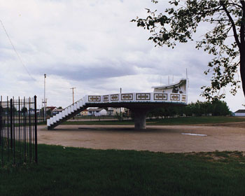
-
Article
St Peter's
St Peter's, NS, incorporated as a village in, inc 1940. St Peter's is situated between St Peter's Inlet and St Peter's Bay on the south shore of Cape Breton Island.
"https://thecanadianencyclopedia.ca/images/tce_placeholder.jpg?v=e9dca980c9bdb3aa11e832e7ea94f5d9" // resources/views/front/categories/view.blade.php
https://thecanadianencyclopedia.ca/images/tce_placeholder.jpg?v=e9dca980c9bdb3aa11e832e7ea94f5d9
-
Article
St. Peters Bay
St. Peters Bay, Prince Edward Island, Rural Municipality, incorporated in 1953, population 231 (2021 census), 237 (2016 census). St. Peters Bay the community is located at the eastern end of St. Peters Bay the body of water, along PEI’s northeastern shore. The village is known for its annual Blueberry Festival and the nearby PEI National Park in Greenwich.
"https://d3d0lqu00lnqvz.cloudfront.net/StPetersBay/DoctorRoddie.jpg" // resources/views/front/categories/view.blade.php
https://d3d0lqu00lnqvz.cloudfront.net/StPetersBay/DoctorRoddie.jpg
-
Article
St Pierre-Jolys
St-Pierre-Jolys, Manitoba, incorporated as a village in 1947, population 1099 (2011c), 839 (2006c). The Village of St-Pierre-Jolys is located 56 km southeast of WINNIPEG near the Rat River.
"https://thecanadianencyclopedia.ca/images/tce_placeholder.jpg?v=e9dca980c9bdb3aa11e832e7ea94f5d9" // resources/views/front/categories/view.blade.php
https://thecanadianencyclopedia.ca/images/tce_placeholder.jpg?v=e9dca980c9bdb3aa11e832e7ea94f5d9
-
Article
St. Stephen
St. Stephen, New Brunswick, incorporated as a town in 1973, population 4,415 (2016 census), 4,817 (2011 census). The town of St. Stephen is located on the St. Croix River in southwestern New Brunswick. First incorporated as a town in 1871, in 1973 St. Stephen was amalgamated with nearby Milltown (incorporated 1878) to form St. Stephen-Milltown. The incorporated name of St. Stephen has been used since 1975.
"https://thecanadianencyclopedia.ca/images/tce_placeholder.jpg?v=e9dca980c9bdb3aa11e832e7ea94f5d9" // resources/views/front/categories/view.blade.php
https://thecanadianencyclopedia.ca/images/tce_placeholder.jpg?v=e9dca980c9bdb3aa11e832e7ea94f5d9
-
Article
St Thomas
St Thomas, Ont, incorporated as a city in 1881, seat of Elgin County, population 37 905 (2011c), 36 110 (2006c). The City of St Thomas is located in southwestern Ontario, 29 km south of London. In 1803 Thomas TALBOT began to place settlers on a large tract of land he owned N of Lake Erie.
"https://thecanadianencyclopedia.ca/images/tce_placeholder.jpg?v=e9dca980c9bdb3aa11e832e7ea94f5d9" // resources/views/front/categories/view.blade.php
https://thecanadianencyclopedia.ca/images/tce_placeholder.jpg?v=e9dca980c9bdb3aa11e832e7ea94f5d9
-
Article
Stadacona
Stadacona was an Iroquoian village located at the present site of Quebec City, Quebec. It had an estimated population of about 500. French navigator Jacques Cartier was led to the village on his second voyage in 1535 and wintered at a safe distance, across the St-Charles River.
"https://d3d0lqu00lnqvz.cloudfront.net/media/media/24df7e90-74bb-4e4d-99ad-e63d85d72d54.jpg" // resources/views/front/categories/view.blade.php
https://d3d0lqu00lnqvz.cloudfront.net/media/media/24df7e90-74bb-4e4d-99ad-e63d85d72d54.jpg