Browse "Places"
-
Article
Old Crow Plain
The Old Crow Plain, about 5,000 km2, elevation 300 m, referred to locally as Old Crow Flats, is the northernmost part of the Porcupine Plateau in the Yukon, lying north of the Arctic Circle and 150 km south of the Beaufort Sea. The plain is a pristine wilderness area underlain by continuous permafrost and covered with a myriad of shallow lakes and ponds, some of which have an oriented rectangular shape related to prevailing wind directions and to patterned ground phenomena, (e.g., ice polygons and wedges). Its name honours the memory of a chieftain of the Gwich'in tribe.
"https://d3d0lqu00lnqvz.cloudfront.net/media/media/3372115f-2e5f-492c-a1d9-de73d4668939.jpg" // resources/views/front/categories/view.blade.php
https://d3d0lqu00lnqvz.cloudfront.net/media/media/3372115f-2e5f-492c-a1d9-de73d4668939.jpg
-
Article
Old Log Church Museum
The Old Log Church Museum is an Anglican church, built in 1900 in Whitehorse, Yukon Territory.
"https://d3d0lqu00lnqvz.cloudfront.net/media/media/bf260975-3834-45d5-82ea-1e34363b2b26.jpg" // resources/views/front/categories/view.blade.php
https://d3d0lqu00lnqvz.cloudfront.net/media/media/bf260975-3834-45d5-82ea-1e34363b2b26.jpg
-
Article
Old Meeting House and Barrington Woolen Mill
The Barrington Woolen Mill is a typical late-19th-century mill. Established in 1882, the mill operated up to 1962. It is perhaps most notable for its excellent collection of looms, spinning jennies, carding machines and other early mill equipment and machinery.
"https://d3d0lqu00lnqvz.cloudfront.net/media/media/b025b87d-c65d-40cc-af2a-c487a30e8c2c.jpg" // resources/views/front/categories/view.blade.php
https://d3d0lqu00lnqvz.cloudfront.net/media/media/b025b87d-c65d-40cc-af2a-c487a30e8c2c.jpg
-
Article
Old Montreal
Old Montreal is the historic district of the city of Montreal, located in the south-central part of Montreal Island and bounded by the St. Lawrence River to the south, Saint-Antoine Street to the north, McGill Street to the west and Saint-Hubert Street to the east. In the second half of the 20th century, this area came under pressure from urban change, as business and port activity shifted elsewhere, depriving Old Montreal of its historic roles. But in the 1960s, a long process began that completely transformed it into a heritage district (it was at this time that the name Old Montreal came into common use). The designation of the Arrondissement historique de Montréal by the Quebec government in 1964 marked an important step in this transformation. With massive investments from the three levels of government, as well as from businesses and individuals, a lengthy rehabilitation effort began. Nearly 60 years later, visitors can now follow the traces of Montreal’s history back to pre-colonial times, and the changes that the city has undergone since the first European settlers arrived in 1642.
"https://d3d0lqu00lnqvz.cloudfront.net/media/media/8d2c56dc-ee18-46a6-97c9-5270de290831.JPG" // resources/views/front/categories/view.blade.php
https://d3d0lqu00lnqvz.cloudfront.net/media/media/8d2c56dc-ee18-46a6-97c9-5270de290831.JPG
-
Article
Old Quebec
Old Quebec is a historic district of Quebec City, designated UNESCO World Heritage site in 1985. It is divided in two sectors: the Lower Town, concentrated around Place Royale and harbour facilities, and the Upper Town, delineated by its ramparts, the Citadel and other defensive structures. Together, they cover a surface area of approximately 135 hectares (1.35 km). Originally chosen by Samuel de Champlain for the construction of his first Abitation in 1608, the site grew during the 17th and 18th centuries and was established atop the promontory of Cap Diamant, gaining strategic and military advantages. The city then surrounded itself with thick fortifications which mark the district borders to this day. Despite the transformations it has undergone since the 19th century, Old Quebec remains a coherent and well-structured architectural ensemble, making Quebec City one of the most successfully preserved fortified cities from colonial times.
"https://d3d0lqu00lnqvz.cloudfront.net/media/new_article_images/VieuxQuebec/dreamstime_xl_32019574.jpg" // resources/views/front/categories/view.blade.php
https://d3d0lqu00lnqvz.cloudfront.net/media/new_article_images/VieuxQuebec/dreamstime_xl_32019574.jpg
-
Article
Olds
Olds, Alta, incorporated as a town in 1905, population 8235 (2011c), 7253 (2006c). The Town of Olds is situated in a transition zone between prairie grassland and partially wooded parkland 89 km north of Calgary.
"https://thecanadianencyclopedia.ca/images/tce_placeholder.jpg?v=e9dca980c9bdb3aa11e832e7ea94f5d9" // resources/views/front/categories/view.blade.php
https://thecanadianencyclopedia.ca/images/tce_placeholder.jpg?v=e9dca980c9bdb3aa11e832e7ea94f5d9
-
Article
O'Leary
O'Leary, PEI, incorporated as a village in 1951 and as a community in 1983, population 812 (2011c), 861 (2006c).The Community of O'Leary is situated in Prince County 59 km northwest of SUMMERSIDE. It came into being after 1874,
"https://thecanadianencyclopedia.ca/images/tce_placeholder.jpg?v=e9dca980c9bdb3aa11e832e7ea94f5d9" // resources/views/front/categories/view.blade.php
https://thecanadianencyclopedia.ca/images/tce_placeholder.jpg?v=e9dca980c9bdb3aa11e832e7ea94f5d9
-
Article
Oliver
Oliver, BC, incorporated as a village in 1945 and as a town in 1991, population 4824 (2011c), 4395 (2006c). The Town of Oliver is located in the OKANAGAN VALLEY, 27 km south of Penticton.
"https://thecanadianencyclopedia.ca/images/tce_placeholder.jpg?v=e9dca980c9bdb3aa11e832e7ea94f5d9" // resources/views/front/categories/view.blade.php
https://thecanadianencyclopedia.ca/images/tce_placeholder.jpg?v=e9dca980c9bdb3aa11e832e7ea94f5d9
-
Article
One Yellow Rabbit Performance Theatre
For its first six years, One Yellow Rabbit was run as a collective by founding members Gyllian Raby (its artistic director), Michael Green, Blake Brooker, Nigel Scott, Kirk Miles, Jan Stirling, George McFaul and Marianne Moroney.
"https://d3d0lqu00lnqvz.cloudfront.net/media/media/34830d23-e6a3-4146-b3c3-48841770d398.jpg" // resources/views/front/categories/view.blade.php
https://d3d0lqu00lnqvz.cloudfront.net/media/media/34830d23-e6a3-4146-b3c3-48841770d398.jpg
-
Article
Ontario
Ontario is a Canadian province bounded by Manitoba to the west, Hudson Bay to the north, Québec to the east, and New York, the Great Lakes, Michigan and Minnesota to the south. The province was founded on parts of the traditional territories of the Ojibwa, Odawa, Potawatomi, Algonquin, Mississauga, Haudenosaunee, Neutral, Wendat, Cree, Oji-Cree and Métis. The land is now governed by 46 treaties, including the Upper Canada, Williams and Robinson treaties, as well as Treaties 3, 5 and 9. As of the 2021 census, Ontario had 14,223,942 residents, making it the most populous province or territory in Canada. Ontario was one of the founding members of Confederation, along with New Brunswick, Nova Scotia and Québec, in 1867. The capital city of Ontario is Toronto. Doug Ford is the province’s current premier, leading a majority Progressive Conservative government.
"https://d3d0lqu00lnqvz.cloudfront.net/media/media/dea1b6f4-4cd1-448c-b08b-41dd597ec05e.jpg" // resources/views/front/categories/view.blade.php
https://d3d0lqu00lnqvz.cloudfront.net/media/media/dea1b6f4-4cd1-448c-b08b-41dd597ec05e.jpg
-
Timelines
Ontario
Ontario is Canada's most populous and second-largest province. It stretches from Canada's southernmost point at Middle Island in Lake Erie in the south, to the Manitoba-Ontario border on Hudson Bay in the north, and from the banks of the St. Lawrence River in the east, to the Manitoba border in the west.
"https://d3d0lqu00lnqvz.cloudfront.net/media/media/08da0fa3-1249-445f-9b67-c59bc9256242.JPG" // resources/views/front/categories/view.blade.php
https://d3d0lqu00lnqvz.cloudfront.net/media/media/08da0fa3-1249-445f-9b67-c59bc9256242.JPG
-
Article
Ontario Place
Ontario Place is a 155-acre tourist attraction located on the Lake Ontario shoreline in Toronto. Operated by the Province of Ontario, the park opened on 22 May 1971. A highlight of the $29-million project was the Cinesphere, the world’s first permanent IMAX theatre. Aside from Atlantis (an event space), the marina and its music venues, the provincial government closed Ontario Place between 2012 and 2017 to save money. While many of the park’s attractions permanently closed during this period, others, such as the Cinesphere, reopened. The provincial government is working with various developers to further reimagine the space.
"https://d3d0lqu00lnqvz.cloudfront.net/media/new_article_images/OntarioPlace/OntarioPlaceCinesphere80s.jpg" // resources/views/front/categories/view.blade.php
https://d3d0lqu00lnqvz.cloudfront.net/media/new_article_images/OntarioPlace/OntarioPlaceCinesphere80s.jpg
-
Article
Ontario Place Forum
Ontario Place Forum. Outdoor amphitheatre, part of Ontario Place, a provincially-operated recreational park opened in 1971 on three man-made islands off the Toronto waterfront. The Forum is circular in design and set in a basin created by four hills.
"https://thecanadianencyclopedia.ca/images/tce_placeholder.jpg?v=e9dca980c9bdb3aa11e832e7ea94f5d9" // resources/views/front/categories/view.blade.php
https://thecanadianencyclopedia.ca/images/tce_placeholder.jpg?v=e9dca980c9bdb3aa11e832e7ea94f5d9
-
Article
Ontario's Greenbelt
Ontario’s Greenbelt, also known as the Greater Golden Horseshoe Greenbelt, is about 800,000 hectares of permanently protected green space and farmland in Ontario. It is one of many prominent greenbelts worldwide, including the British Columbia Agricultural Land Reserve in Canada and greenbelts in Copenhagen, Brazil, London, England and elsewhere. The Greenbelt forms a “belt” around the Greater Golden Horseshoe, Canada’s most densely populated area. The region includes municipalities such as Toronto, Oakville, Pickering, Hamilton, and Mississauga and stretches from Rice Lake in the east to the Niagara River in the west. The Greenbelt was created in 2005 to protect high-quality farmland and environmentally sensitive features like forests, lakes and sensitive species from urban sprawl and development.
"https://d3d0lqu00lnqvz.cloudfront.net/greenbelt/oak-ridges-moraine.jpg" // resources/views/front/categories/view.blade.php
https://d3d0lqu00lnqvz.cloudfront.net/greenbelt/oak-ridges-moraine.jpg
-
Article
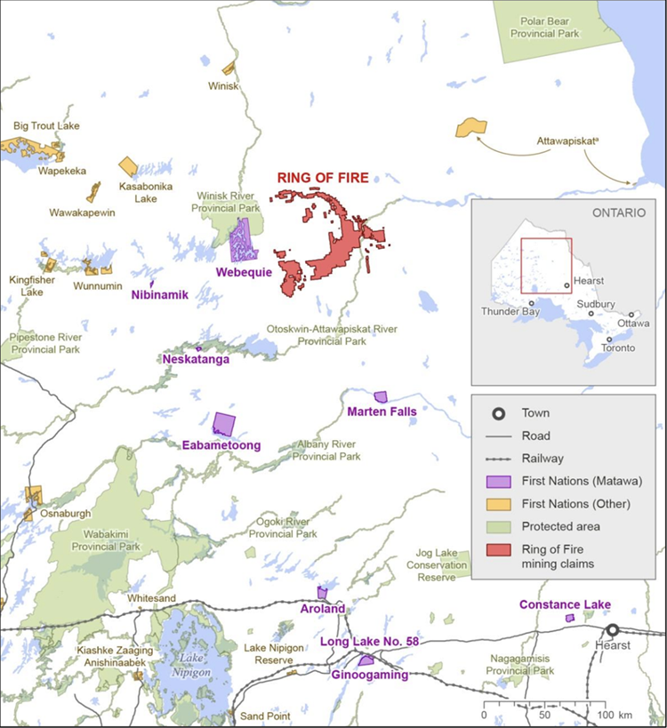
Ontario’s Ring of Fire
Ontario’s Ring of Fire, 8,000 km², refers to a region of critical mineral deposits in the James Bay lowlands of Northern Ontario. Located within the traditional territory covered by Treaty 9, it has become a focal point of conflict over resource development, Indigenous rights and environmental protections.
"https://d3d0lqu00lnqvz.cloudfront.net/ringoffire/Ring_of_Fire_-_Ontario.png" // resources/views/front/categories/view.blade.php
https://d3d0lqu00lnqvz.cloudfront.net/ringoffire/Ring_of_Fire_-_Ontario.png