
Browse "Places"
-
Article
Vuntut National Park
A portion of the Old Crow Plain (locally called the Old Crow Flats) was set aside, through the settlement of the Vuntut Gwitchin comprehensive land claim in 1993, for Vuntut National Park (established 1995, 4345 km2). The park is bound to the north by Ivvavik National Park and to the west by Alaska. Access to Vuntut National Park is by charter aircraft from the village of Old Crow, which only has year-round scheduled air service, or by a long canoe journey.
"https://d3d0lqu00lnqvz.cloudfront.net/media/media/0280eee2-9f7c-4cb4-a65b-a6e43d457819.jpg" // resources/views/front/categories/view.blade.php
https://d3d0lqu00lnqvz.cloudfront.net/media/media/0280eee2-9f7c-4cb4-a65b-a6e43d457819.jpg
-
Article
Wabana
Wabana, NL, incorporated as a town in 1950, population 2346 (2011c), 2418 (2006c). The Town of Wabana is located on the north end of BELL ISLAND in Conception Bay and is the principal community on the island.
"https://thecanadianencyclopedia.ca/images/tce_placeholder.jpg?v=e9dca980c9bdb3aa11e832e7ea94f5d9" // resources/views/front/categories/view.blade.php
https://thecanadianencyclopedia.ca/images/tce_placeholder.jpg?v=e9dca980c9bdb3aa11e832e7ea94f5d9
-
Article
Wabush
Wabush, Newfoundland and Labrador, incorporated as a town in 1967, population 1,964 (2021 census), 1,906 (2016 census). The town of Wabush is located in western Labrador, close to the Quebec border, 5 km south of Labrador City. It lies next to Wabush Lake, Little Wabush Lake and Jean Lake.
"https://d3d0lqu00lnqvz.cloudfront.net/media/media/c69fd2dd-93c8-473f-bccc-544aeae5d395.jpg" // resources/views/front/categories/view.blade.php
https://d3d0lqu00lnqvz.cloudfront.net/media/media/c69fd2dd-93c8-473f-bccc-544aeae5d395.jpg
-
Article
Wadena
Wadena, Sask, incorporated as a town in 1912, population 1306 (2011c), 1315 (2006c). The Town of Wadena is located about 200 km east of SASKATOON near the Quill Lakes. In the 18th century this area was the territory of the Saulteaux.
"https://thecanadianencyclopedia.ca/images/tce_placeholder.jpg?v=e9dca980c9bdb3aa11e832e7ea94f5d9" // resources/views/front/categories/view.blade.php
https://thecanadianencyclopedia.ca/images/tce_placeholder.jpg?v=e9dca980c9bdb3aa11e832e7ea94f5d9
-
Article
Wainwright
Wainwright, Alta, incorporated as a town in 1910, population 5925 (2011c), 5426 (2006c). The Town of Wainwright is located 200 km southeast of Edmonton. The first settlement, Denwood, established in 1906, was moved in its entirety to a railway divisional point 4 km away in 1908.
"https://thecanadianencyclopedia.ca/images/tce_placeholder.jpg?v=e9dca980c9bdb3aa11e832e7ea94f5d9" // resources/views/front/categories/view.blade.php
https://thecanadianencyclopedia.ca/images/tce_placeholder.jpg?v=e9dca980c9bdb3aa11e832e7ea94f5d9
-
Article
Walhachin
Walhachin The turn of the century in British Columbia was a time of economic prosperity. The optimism associated with this prosperity enabled land speculators to attract upper-class Englishmen to purchase land and settle at Walhachin.
"https://thecanadianencyclopedia.ca/images/tce_placeholder.jpg?v=e9dca980c9bdb3aa11e832e7ea94f5d9" // resources/views/front/categories/view.blade.php
https://thecanadianencyclopedia.ca/images/tce_placeholder.jpg?v=e9dca980c9bdb3aa11e832e7ea94f5d9
-
Article
Walker Theatre
Designed by Howard C. Stone of Montréal, the Walker was modelled on the famous Auditorium Theatre in Chicago (erected in 1889; designed by Adler and Sullivan) which is surrounded by a commercial complex.
"https://d3d0lqu00lnqvz.cloudfront.net/media/media/da543db2-770a-4cbc-9bab-1cedd9c850f4.jpg" // resources/views/front/categories/view.blade.php
https://d3d0lqu00lnqvz.cloudfront.net/media/media/da543db2-770a-4cbc-9bab-1cedd9c850f4.jpg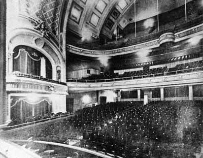
-
Article
Walkerton
Walkerton was settled in the mid-1850s and quickly developed as an important mill site and service centre for the surrounding area. In the 1860s it became the seat of the county's government.
"https://d3d0lqu00lnqvz.cloudfront.net/media/media/d3d7cda1-2e1e-4331-8fb8-0167a07a5ecb.jpg" // resources/views/front/categories/view.blade.php
https://d3d0lqu00lnqvz.cloudfront.net/media/media/d3d7cda1-2e1e-4331-8fb8-0167a07a5ecb.jpg
-
Article
Wallaceburg
Wallaceburg, Ontario, population centre, population 10,098 (2016 census), 10,127 (2011 census). Wallaceburg is a community located on the Sydenham River. Formerly a town (incorporated 1896), in 1998 Wallaceburg became a part of the new municipality of Chatham-Kent.
"https://d3d0lqu00lnqvz.cloudfront.net/media/media/d8a333ce-69c9-4063-9d7d-94a754908757.jpg" // resources/views/front/categories/view.blade.php
https://d3d0lqu00lnqvz.cloudfront.net/media/media/d8a333ce-69c9-4063-9d7d-94a754908757.jpg
-
Article
Wanipigow Lake Archaeological Site
Wanipigow Lake is a narrow, shallow widening of the river of the same name that flows in a northwesterly direction across the Canadian Canadian Shield and into Lake Winnipeg.
"https://d3d0lqu00lnqvz.cloudfront.net/media/media/e5091b2b-bb00-4462-aac4-82e75631762a.jpg" // resources/views/front/categories/view.blade.php
https://d3d0lqu00lnqvz.cloudfront.net/media/media/e5091b2b-bb00-4462-aac4-82e75631762a.jpg
-
Article
Wapusk National Park
Wapusk National Park (11,475.0 km2) became part of Canada's national parks system on 24 April 1996 when a federal-provincial agreement was signed providing for its establishment. This national park extends to the east and south of Churchill, Manitoba, and protects a representative sample of the features and wildlife of the Hudson and James Bay lowlands.
"https://d3d0lqu00lnqvz.cloudfront.net/media/media/2288f5ad-7780-4e6a-b579-e6f1614efd4e.jpg" // resources/views/front/categories/view.blade.php
https://d3d0lqu00lnqvz.cloudfront.net/media/media/2288f5ad-7780-4e6a-b579-e6f1614efd4e.jpg
-
Article
Ward Effigy Archaeological Site
The Ward Effigy Archaeological Site (Borden No. EfPf-16) is located immediately north of the Siksika Nation reserve, about 100 km east of Calgary, Alberta.
"https://d3d0lqu00lnqvz.cloudfront.net/media/media/5ec4da46-ab78-4295-8399-a789f3ae1350.jpg" // resources/views/front/categories/view.blade.php
https://d3d0lqu00lnqvz.cloudfront.net/media/media/5ec4da46-ab78-4295-8399-a789f3ae1350.jpg
-
Article
Warman
Warman, Sask, incorporated as a town in 1966, population 7084 (2011c), 4769 (2006c). The Town of Warman is located about 20 km north of SASKATOON. In 1890 the Qu'Appelle, Long Lake and Saskatchewan Railway was completed from
"https://thecanadianencyclopedia.ca/images/tce_placeholder.jpg?v=e9dca980c9bdb3aa11e832e7ea94f5d9" // resources/views/front/categories/view.blade.php
https://thecanadianencyclopedia.ca/images/tce_placeholder.jpg?v=e9dca980c9bdb3aa11e832e7ea94f5d9
-
Article
Wasaga Beach
Wasaga Beach, ON, incorporated as a town in 1974, population 24,862 (2021 census), 20,675 (2016 census). The Town of Wasaga Beach is located on the shores of Georgian Bay at the mouth of the Nottawasaga River, about 40 km northwest of Barrie. Wasaga Beach is the world's longest freshwater beach. The name was derived from the Nottawasaga River.
"https://d3d0lqu00lnqvz.cloudfront.net/media/media/8237f72b-ad4c-4821-94f6-f615920cc3e5.jpg" // resources/views/front/categories/view.blade.php
https://d3d0lqu00lnqvz.cloudfront.net/media/media/8237f72b-ad4c-4821-94f6-f615920cc3e5.jpg
-
Article
Waskahegan Trail
Waskahegan Trail is a regional hiking trail of more than 300 km developed in and around EDMONTON, Alta. It began as a Canadian Centennial project (1967) to promote hiking opportunities in Alberta's capital region. Similar in
"https://thecanadianencyclopedia.ca/images/tce_placeholder.jpg?v=e9dca980c9bdb3aa11e832e7ea94f5d9" // resources/views/front/categories/view.blade.php
https://thecanadianencyclopedia.ca/images/tce_placeholder.jpg?v=e9dca980c9bdb3aa11e832e7ea94f5d9