
Browse "Places"
-
Article
Prince Albert National Park
Prince Albert National Park (est 1927, 3874.3 km2) is located 200 km north of Saskatoon. The cabin and grave of Grey Owl (Archibald Belaney) are located in the park beside Ajawaan Lake, where he spent the last 7 years of his life.
"https://d3d0lqu00lnqvz.cloudfront.net/media/media/f507b630-0ecd-47f8-b3a8-7ef49ed586c9.jpg" // resources/views/front/categories/view.blade.php
https://d3d0lqu00lnqvz.cloudfront.net/media/media/f507b630-0ecd-47f8-b3a8-7ef49ed586c9.jpg
-
Article
Prince Charles Island
Prince Charles Island, Nunavut, 9521 km2, 130 km long and 100 km wide, is the largest island in Foxe Basin.
"https://thecanadianencyclopedia.ca/images/tce_placeholder.jpg?v=e9dca980c9bdb3aa11e832e7ea94f5d9" // resources/views/front/categories/view.blade.php
https://thecanadianencyclopedia.ca/images/tce_placeholder.jpg?v=e9dca980c9bdb3aa11e832e7ea94f5d9
-
Article
Prince Edward Island
Prince Edward Island is Canada's smallest province, making up just 0.1 per cent of Canada’s total land area. It is situated in the Gulf of St Lawrence and separated from Nova Scotia and New Brunswick by the Northumberland Strait. PEI was known to its earliest settlers, the Mi’kmaq as Epekwitk, meaning "lying in the water place,” and was described by Jacques Cartier in 1534 as "the fairest land that may possibly be seen." PEI's deep red soil has always been its most striking feature and, together with the sea, the mainstay of the population since the early 18th century.
"https://d3d0lqu00lnqvz.cloudfront.net/media/media/52a0fff7-104a-49cf-a3a8-f815e9e93b5b.jpg" // resources/views/front/categories/view.blade.php
https://d3d0lqu00lnqvz.cloudfront.net/media/media/52a0fff7-104a-49cf-a3a8-f815e9e93b5b.jpg
-
Timelines
Prince Edward Island
Prince Edward Island is Canada's smallest province, making up just 0.1 per cent of Canada’s total land area. It is situated in the Gulf of St Lawrence and separated from Nova Scotia and New Brunswick by the Northumberland Strait.
"https://d3d0lqu00lnqvz.cloudfront.net/media/media/52a0fff7-104a-49cf-a3a8-f815e9e93b5b.jpg" // resources/views/front/categories/view.blade.php
https://d3d0lqu00lnqvz.cloudfront.net/media/media/52a0fff7-104a-49cf-a3a8-f815e9e93b5b.jpg
-
Article
Prince Edward Island National Park
Prince Edward Island National Park (est 1937, 21.5 km2) is a narrow strip of coastline stretching over 40 km along the north shore of PEI.
"https://d3d0lqu00lnqvz.cloudfront.net/media/media/43c98966-afd6-46ad-88a3-937937a88fff.jpg" // resources/views/front/categories/view.blade.php
https://d3d0lqu00lnqvz.cloudfront.net/media/media/43c98966-afd6-46ad-88a3-937937a88fff.jpg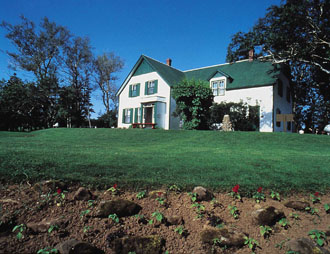
-
Article
Prince George
Prince George, British Columbia, incorporated as a city in 1915, population 76,708 (2021 census), 74,003 (2016 census). Prince George is the largest city in the northern part of the province. It is situated in the geographical centre of British Columbia at the junction of the Nechako and Fraser rivers. Prince George was founded on the traditional territory of the Lheidli T'enneh, a sub-group of the Dakelh or Carrier Dene. The Dakelh aided Alexander Mackenzie on his journey to the Pacific coast in 1793.
"https://d3d0lqu00lnqvz.cloudfront.net/media/media/5cada4a2-0076-4515-b8d0-dfad91ba5c9a.jpg" // resources/views/front/categories/view.blade.php
https://d3d0lqu00lnqvz.cloudfront.net/media/media/5cada4a2-0076-4515-b8d0-dfad91ba5c9a.jpg
-
Article
Prince of Wales Fort
Prince of Wales Fort is an 18th-century fortification built by the Hudson’s Bay Company at the mouth of the Churchill River, in what is now Manitoba. Today, it is a national historic site managed by Parks Canada.
"https://d3d0lqu00lnqvz.cloudfront.net/media/media/8c5faba2-5909-4aa1-ba38-6e503757042e.jpg" // resources/views/front/categories/view.blade.php
https://d3d0lqu00lnqvz.cloudfront.net/media/media/8c5faba2-5909-4aa1-ba38-6e503757042e.jpg
-
Article
Prince of Wales Island
Prince of Wales Island, Nunavut, 33,339 km2, is the eighth-largest island in the Arctic Archipelago.
"https://d3d0lqu00lnqvz.cloudfront.net/Prince_of_Wales_Island.png" // resources/views/front/categories/view.blade.php
https://d3d0lqu00lnqvz.cloudfront.net/Prince_of_Wales_Island.png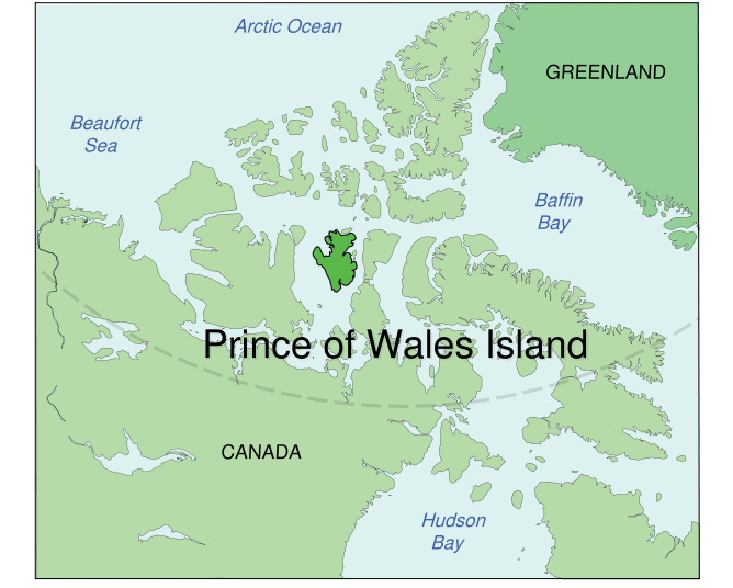
-
Article
Prince of Wales Strait
Prince of Wales Strait is situated in the Arctic Archipelago between the uplands of western Victoria Island and the east coast of Banks Island.
"https://d3d0lqu00lnqvz.cloudfront.net/media/media/6fcc972b-865e-4086-b585-c230cb7d350b.jpg" // resources/views/front/categories/view.blade.php
https://d3d0lqu00lnqvz.cloudfront.net/media/media/6fcc972b-865e-4086-b585-c230cb7d350b.jpg
-
Article
Prince Patrick Island
Prince Patrick Island, 15 848 km2, is the farthest west of Canada's Arctic Queen Elizabeth Islands.
"https://thecanadianencyclopedia.ca/images/tce_placeholder.jpg?v=e9dca980c9bdb3aa11e832e7ea94f5d9" // resources/views/front/categories/view.blade.php
https://thecanadianencyclopedia.ca/images/tce_placeholder.jpg?v=e9dca980c9bdb3aa11e832e7ea94f5d9
-
Article
Prince Rupert
Prince Rupert, BC, incorporated as a city in 1910, population 12,300 (2021 census), 12,220 (2016 census). The City of Prince Rupert is located on Kaien Island, at the mouth of the Skeena River in the Coast Mountains of British Columbia. It is Canada's wettest city, with an average of 2,619 mm of precipitation falling each year. Prince Rupert marks western end of the Yellowhead Trans-Canada Highway and, as Canada's deepest ice-free seaport, a link between the lower United States, Vancouver and Alaska (see also Iconic Highways in Canada). For these reasons it is the industrial, commercial and institutional centre for BC's Northwest Coast.
"https://d3d0lqu00lnqvz.cloudfront.net/media/media/adb7f8d5-a8d7-465c-8567-2d8d0de2e468.jpg" // resources/views/front/categories/view.blade.php
https://d3d0lqu00lnqvz.cloudfront.net/media/media/adb7f8d5-a8d7-465c-8567-2d8d0de2e468.jpg
-
Article
Princess of Wales Theatre
Considered a Toronto landmark, the Princess of Wales Theatre is located at 300 King Street West in Toronto's entertainment district.
"https://d3d0lqu00lnqvz.cloudfront.net/media/media/2377ba89-8cef-4261-8bc5-9705d3ff2c4d.jpg" // resources/views/front/categories/view.blade.php
https://d3d0lqu00lnqvz.cloudfront.net/media/media/2377ba89-8cef-4261-8bc5-9705d3ff2c4d.jpg
-
Article
Princeton
Princeton, BC, incorporated as a town in 1978, population 2724 (2011c), 2780 (2006c). The Town of Princeton is located at the junction of the Tulameen and Similkameen rivers, 114 km west of PENTICTON.
"https://thecanadianencyclopedia.ca/images/tce_placeholder.jpg?v=e9dca980c9bdb3aa11e832e7ea94f5d9" // resources/views/front/categories/view.blade.php
https://thecanadianencyclopedia.ca/images/tce_placeholder.jpg?v=e9dca980c9bdb3aa11e832e7ea94f5d9
-
Article
Principal Reservoirs in Canada
Principal Reservoirs in Canada Principal Reservoirs in Canada Reservoir River Province Storage Capacity* Year Operational Lake St Lawrence St Lawrence Ontario 808 1958 Cross-Cedar Lake Saskatchewan Manitoba 9643 1965 Williston Lake Peace BC 70 309 1968 Manicouagan Manicouagan Québec 141 851 1968 Lake Diefenbaker South Saskatchewan Saskatchewan 9868 1972 Kinbasket Lake Columbia BC 24 670 1972 Wreck Cove Wreck Cove Nova Scotia 126 1978 Hinds Lake Humber Newfoundland 305 1980 SmallwoodChurchillLabrador28 0001971 *millions of cubic...
"https://thecanadianencyclopedia.ca/images/tce_placeholder.jpg?v=e9dca980c9bdb3aa11e832e7ea94f5d9" // resources/views/front/categories/view.blade.php
https://thecanadianencyclopedia.ca/images/tce_placeholder.jpg?v=e9dca980c9bdb3aa11e832e7ea94f5d9
-
Article
Protected Areas
The International Union for Conservation of Nature (IUCN) definition of a protected area is "a clearly defined geographical space, recognized, dedicated, and managed, through legal or other effective means, to achieve the long-term conservation of nature with associated ecosystem services and cultural values." Protected areas may be comprised of terrestrial, freshwater, or marine areas, or a combination of the above.
"https://d3d0lqu00lnqvz.cloudfront.net/algonquinprovincialpark/Wetland.jpg" // resources/views/front/categories/view.blade.php
https://d3d0lqu00lnqvz.cloudfront.net/algonquinprovincialpark/Wetland.jpg