Article
Bruce Trail
The Bruce Trail is a continuous, 740 km footpath on the Niagara Escarpment
Signing up enhances your TCE experience with the ability to save items to your personal reading list, and access the interactive map.
Create Account"https://d3d0lqu00lnqvz.cloudfront.net/media/media/ca0f5c71-ef4f-4fe0-bbd9-69e1452afbbe.jpg" // resources/views/front/categories/view.blade.phphttps://d3d0lqu00lnqvz.cloudfront.net/media/media/ca0f5c71-ef4f-4fe0-bbd9-69e1452afbbe.jpg

Article
The original Dewdney Trail was a 400 km trail route extending from Hope to Galbraith's Ferry on the Kootenay River. The trail was routed and constructed under the supervision of Edgar DEWDNEY, a civil engineer appointed by Frederick Seymour, the governor of the colony of BC, in April 1865.
"https://www.thecanadianencyclopedia.ca/images/tce_placeholder.jpg?v=e9dca980c9bdb3aa11e832e7ea94f5d9" // resources/views/front/categories/view.blade.phphttps://www.thecanadianencyclopedia.ca/images/tce_placeholder.jpg?v=e9dca980c9bdb3aa11e832e7ea94f5d9

Article
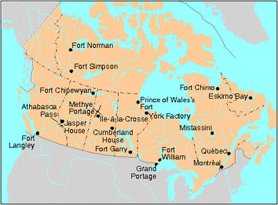
Throughout the period of the historical fur trade (early 17th to the mid-19th century), water routes were the natural “highways” of First Nations trappers and European fur traders. Water trading networks connected Indigenous societies from the Atlantic Ocean, along the St. Lawrence River to the Great Lakes, and then on towards the Hudson Bay watershed. North America’s waterborne geography facilitated intracontinental travel, enabled European expansion and settlement into Indigenous North America, and shaped the contours of Euro-Indigenous relations in the context of the fur trade. These extensive and interconnected systems of rivers, lakes and overland trails criss-crossed Indigenous territories and had been used for generations. At the height of the fur trade, the principal canoe route extended westward from the Island of Montreal through the Great Lakes, and from the northwestern shore of Lake Superior over the height of land into the Hudson Bay watershed. From the Lake Winnipeg basin, Indigenous trappers and European traders fanned out towards the Western Prairies via the Assiniboine, Qu’Appelle and Souris rivers, towards the foothills of the Rocky Mountains via the North and South branches of the Saskatchewan River, and finally towards the Athabasca Country via the Sturgeon-weir River and the Methye Portage.
"https://d3d0lqu00lnqvz.cloudfront.net/media/media/6a52818a-3f78-427a-a201-5e6bc9c5d874.jpg" // resources/views/front/categories/view.blade.phphttps://d3d0lqu00lnqvz.cloudfront.net/media/media/6a52818a-3f78-427a-a201-5e6bc9c5d874.jpg

Article
Grand Portage was a fur-trade depot and route of the voyageurs at the western extremity of Lake Superior.
"https://d3d0lqu00lnqvz.cloudfront.net/media/media/a4d6e476-5e53-4126-9ee6-313b64235660.jpg" // resources/views/front/categories/view.blade.phphttps://d3d0lqu00lnqvz.cloudfront.net/media/media/a4d6e476-5e53-4126-9ee6-313b64235660.jpg
Article
Great Divide Trail is a long-distance hiking trail, paralleling where possible the CONTINENTAL DIVIDE of Canada's Rocky Mts range. Some 560 km of the trail lies within the boundaries of Banff, Kootenay, Yoho and Jasper national parks, extending from Palliser Pass in the S to Mt ROBSON in the N.
"https://www.thecanadianencyclopedia.ca/images/tce_placeholder.jpg?v=e9dca980c9bdb3aa11e832e7ea94f5d9" // resources/views/front/categories/view.blade.phphttps://www.thecanadianencyclopedia.ca/images/tce_placeholder.jpg?v=e9dca980c9bdb3aa11e832e7ea94f5d9
Article
The Mackenzie-Grease Trail represents the final 350 km link which Alexander Mackenzie followed in the first recorded crossing of continental North America in 1793.
"https://www.thecanadianencyclopedia.ca/images/tce_placeholder.jpg?v=e9dca980c9bdb3aa11e832e7ea94f5d9" // resources/views/front/categories/view.blade.phphttps://www.thecanadianencyclopedia.ca/images/tce_placeholder.jpg?v=e9dca980c9bdb3aa11e832e7ea94f5d9
Article
Portage is a way by land around an interruption in a water route. Until the early 19th century most inhabitants of what is now Canada travelled mainly by water. Alexander Mackenzie and Simon Fraser demonstrated that it is possible, by portaging 100 times, to canoe from the St Lawrence to the Arctic or Pacific oceans.
"https://d3d0lqu00lnqvz.cloudfront.net/media/media/6a52818a-3f78-427a-a201-5e6bc9c5d874.jpg" // resources/views/front/categories/view.blade.phphttps://d3d0lqu00lnqvz.cloudfront.net/media/media/6a52818a-3f78-427a-a201-5e6bc9c5d874.jpg
Article
During the summer of 1885 the railway was constructed over the pass at great expense. Over 6.4 km of snowsheds (31) were built to protect trains, trackage and workmen from AVALANCHES (the area receives up to 15 m of snow each winter).
"https://d3d0lqu00lnqvz.cloudfront.net/media/media/4a73903a-ec12-49d4-86cb-2a9cbd3c3f23.jpg" // resources/views/front/categories/view.blade.phphttps://d3d0lqu00lnqvz.cloudfront.net/media/media/4a73903a-ec12-49d4-86cb-2a9cbd3c3f23.jpg

Article
The Trans Canada Trail is over 27,000 km of land and waterways connecting every Canadian province and territory. Construction began in 1992 as part of Canada's 125th birthday celebrations. It was completed 25 years later, in 2017, when Canada turned 150. In 2016, the trail’s name changed to “The Great Trail.” However, in June 2021, the name reverted back to the original.
"https://www.thecanadianencyclopedia.ca/images/tce_placeholder.jpg?v=e9dca980c9bdb3aa11e832e7ea94f5d9" // resources/views/front/categories/view.blade.phphttps://www.thecanadianencyclopedia.ca/images/tce_placeholder.jpg?v=e9dca980c9bdb3aa11e832e7ea94f5d9
Article
Waskahegan Trail is a regional hiking trail of more than 300 km developed in and around EDMONTON, Alta. It began as a Canadian Centennial project (1967) to promote hiking opportunities in Alberta's capital region. Similar in
"https://www.thecanadianencyclopedia.ca/images/tce_placeholder.jpg?v=e9dca980c9bdb3aa11e832e7ea94f5d9" // resources/views/front/categories/view.blade.phphttps://www.thecanadianencyclopedia.ca/images/tce_placeholder.jpg?v=e9dca980c9bdb3aa11e832e7ea94f5d9
Article
West Coast Trail, on W coast of VANCOUVER I, follows the 72 km route of the historic lifesaving trail between the communities of Bamfield and Port Renfrew, BC.
"https://www.thecanadianencyclopedia.ca/images/tce_placeholder.jpg?v=e9dca980c9bdb3aa11e832e7ea94f5d9" // resources/views/front/categories/view.blade.phphttps://www.thecanadianencyclopedia.ca/images/tce_placeholder.jpg?v=e9dca980c9bdb3aa11e832e7ea94f5d9