Article
Springdale
Springdale, NL, incorporated as a town in 1965, population 2907 (2011c), 2764 (2006c). The Town of Springdale is located on the northwest side of Halls Bay near the mouth of the Indian River.
Signing up enhances your TCE experience with the ability to save items to your personal reading list, and access the interactive map.
Create AccountArticle
Springdale, NL, incorporated as a town in 1965, population 2907 (2011c), 2764 (2006c). The Town of Springdale is located on the northwest side of Halls Bay near the mouth of the Indian River.
"https://www.thecanadianencyclopedia.ca/images/tce_placeholder.jpg?v=e9dca980c9bdb3aa11e832e7ea94f5d9" // resources/views/front/categories/view.blade.phphttps://www.thecanadianencyclopedia.ca/images/tce_placeholder.jpg?v=e9dca980c9bdb3aa11e832e7ea94f5d9

Article
Springfield, Manitoba, incorporated as a rural municipality in 1873, population 14 069 (2011c), 12 990 (2006c).
"https://www.thecanadianencyclopedia.ca/images/tce_placeholder.jpg?v=e9dca980c9bdb3aa11e832e7ea94f5d9" // resources/views/front/categories/view.blade.phphttps://www.thecanadianencyclopedia.ca/images/tce_placeholder.jpg?v=e9dca980c9bdb3aa11e832e7ea94f5d9
Article
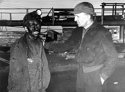
Springhill, NS, incorporated as a town in 1889, population 3868 (2011c), 3941 (2006c). The Town of Springhill, located in the heart of Cumberland County on the Chignecto Isthmus.
"https://d3d0lqu00lnqvz.cloudfront.net/media/media/10dac7dd-3569-432a-8cb3-c5ad5f082f3f.jpg" // resources/views/front/categories/view.blade.phphttps://d3d0lqu00lnqvz.cloudfront.net/media/media/10dac7dd-3569-432a-8cb3-c5ad5f082f3f.jpg
Article
Spruce Grove, Alta, incorporated as a city in 1986, population 26 171 (2011c), 19 541 (2006c). The City of Spruce Grove is located just west of Edmonton and is the eastern neighbour of the town STONY PLAIN. French and Scottish settlers arrived in 1891.
"https://www.thecanadianencyclopedia.ca/images/tce_placeholder.jpg?v=e9dca980c9bdb3aa11e832e7ea94f5d9" // resources/views/front/categories/view.blade.phphttps://www.thecanadianencyclopedia.ca/images/tce_placeholder.jpg?v=e9dca980c9bdb3aa11e832e7ea94f5d9
Article
Squamish, British Columbia, incorporated as a district municipality in 1964, population 23,819 (2021 census), 19,497 (2016 census). The district of Squamish is located 70 km north of Vancouver at the head of Howe Sound. The municipality is governed by a mayor and six councillors. It is the service centre for a richly endowed recreational area, with road, rail and water access to Vancouver.
"https://www.thecanadianencyclopedia.ca/images/tce_placeholder.jpg?v=e9dca980c9bdb3aa11e832e7ea94f5d9" // resources/views/front/categories/view.blade.phphttps://www.thecanadianencyclopedia.ca/images/tce_placeholder.jpg?v=e9dca980c9bdb3aa11e832e7ea94f5d9
Article
St. Alban's, NL, incorporated as a town in 1964, population 1233 (2011c), 1278 (2006c). The Town of St Alban's is located at the mouth of Bay D'Espoir on the south coast of Newfoundland.
"https://d3d0lqu00lnqvz.cloudfront.net/media/media/b429c854-8e79-4688-9843-8158c819faa1.jpg" // resources/views/front/categories/view.blade.phphttps://d3d0lqu00lnqvz.cloudfront.net/media/media/b429c854-8e79-4688-9843-8158c819faa1.jpg

Article
St Albert, Alta, incorporated as a city in 1977, population 61 466 (2011c), 57 764 (2006c). The City of St Albert is located along the northwestern city boundary of EDMONTON.
"https://d3d0lqu00lnqvz.cloudfront.net/media/media/d0a2938b-4548-4d63-8063-2fa2e8a1b54e.jpg" // resources/views/front/categories/view.blade.phphttps://d3d0lqu00lnqvz.cloudfront.net/media/media/d0a2938b-4548-4d63-8063-2fa2e8a1b54e.jpg

Article
St Andrews, Manitoba, incorporated as a rural municipality in 1880, population 11 875 (2011c), 11 359 (2006c). The Rural Municipality of St Andrews stretches from a boundary 8 km north of WINNIPEG to Winnipeg Beach and Netley Marsh at the southern tip of Lake Winnipeg.
"https://www.thecanadianencyclopedia.ca/images/tce_placeholder.jpg?v=e9dca980c9bdb3aa11e832e7ea94f5d9" // resources/views/front/categories/view.blade.phphttps://www.thecanadianencyclopedia.ca/images/tce_placeholder.jpg?v=e9dca980c9bdb3aa11e832e7ea94f5d9
Article
St Anthony, NL, incorporated as a town in 1945, population 2418 (2011c), 2476 (2006c). The Town of St Anthony is located near the top of the Northern Peninsula.
"https://www.thecanadianencyclopedia.ca/images/tce_placeholder.jpg?v=e9dca980c9bdb3aa11e832e7ea94f5d9" // resources/views/front/categories/view.blade.phphttps://www.thecanadianencyclopedia.ca/images/tce_placeholder.jpg?v=e9dca980c9bdb3aa11e832e7ea94f5d9
Article
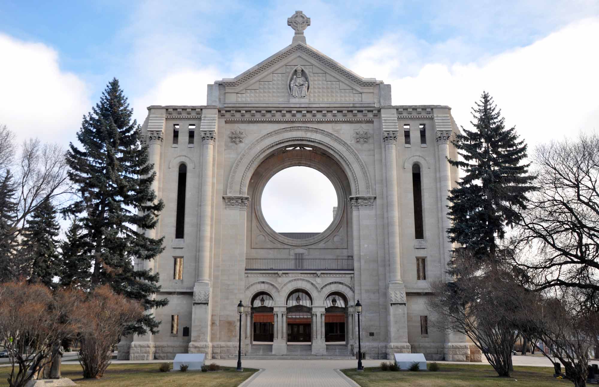
St. Boniface, Manitoba, incorporated as a town in 1883 and a city in 1908, now one of 15 wards in the city of Winnipeg, population 46,035 (2016 census). St. Boniface is located on the banks of the Red and Seine rivers in eastern Winnipeg. One councillor represents St. Boniface on Winnipeg City Council. As one of the larger French communities outside Quebec, it has often been at the centre of struggles to preserve French language and identity within Manitoba.
"https://d3d0lqu00lnqvz.cloudfront.net/media/media/ef9365db-3cb4-4ed6-aa76-73e4674169b4.jpg" // resources/views/front/categories/view.blade.phphttps://d3d0lqu00lnqvz.cloudfront.net/media/media/ef9365db-3cb4-4ed6-aa76-73e4674169b4.jpg
Article
St. Catharines, ON, incorporated as a city in 1876, population 136,803 (2021 census), 133,113 (2016 census). The City of St. Catharines is the principal city of the Niagara Region. It lies south of Toronto across Lake Ontario (111 km by the Queen Elizabeth Way), 19 km inland from the international boundary with the United States, along the Niagara River. The city is named after Catharine Hamilton, wife of Robert Hamilton, an influential merchant of Queenston and a landowner with mills on Twelve Mile Creek; the growing community, then known as The Twelve or Shipman's Corners, was renamed in her honour after her death in 1796. After 1876, as the urban area of St. Catharines expanded, it was permitted to annex parts of the surrounding Grantham Township, culminating in 1961 in the complete amalgamation of the township as well as the adjacent towns of Merritton and Port Dalhousie. In 1970, the rural township of Louth to the west was split between St. Catharines and the new town of Lincoln.
"https://d3d0lqu00lnqvz.cloudfront.net/media/media/0b59b887-a76a-4eea-9406-10f64badd85e.jpg" // resources/views/front/categories/view.blade.phphttps://d3d0lqu00lnqvz.cloudfront.net/media/media/0b59b887-a76a-4eea-9406-10f64badd85e.jpg

Article
This village was the site of a fierce battle during the REBELLIONS OF 1837 as Chenier and the PATRIOTES barricaded themselves in the church, priest's house and convent. Nearly 100 Patriotes were killed and the British troops put the village to the torch.
"https://www.thecanadianencyclopedia.ca/images/tce_placeholder.jpg?v=e9dca980c9bdb3aa11e832e7ea94f5d9" // resources/views/front/categories/view.blade.phphttps://www.thecanadianencyclopedia.ca/images/tce_placeholder.jpg?v=e9dca980c9bdb3aa11e832e7ea94f5d9
Article
St George's, NL, incorporated as a town in 1965, population 1207 (2011c), 1246 (2006c). The Town of St George's is located on the southeast side of St George's Bay, on the west coast of Newfoundland.
"https://www.thecanadianencyclopedia.ca/images/tce_placeholder.jpg?v=e9dca980c9bdb3aa11e832e7ea94f5d9" // resources/views/front/categories/view.blade.phphttps://www.thecanadianencyclopedia.ca/images/tce_placeholder.jpg?v=e9dca980c9bdb3aa11e832e7ea94f5d9
Article
St Hubert MissionSt Hubert Mission, located some 16 km SW of Whitewood, Sask, originated from the settlement of a group of titled French and Belgian nobility that apparently sought to escape from adverse changes undermining their way of life in Europe and to transplant the Old World traditions of French noblesse oblige. In the mid-1880s the representative of a wealthy Frenchman bought land in the area and commenced farming operations. His home, called La Rolanderie,...
"https://www.thecanadianencyclopedia.ca/images/tce_placeholder.jpg?v=e9dca980c9bdb3aa11e832e7ea94f5d9" // resources/views/front/categories/view.blade.phphttps://www.thecanadianencyclopedia.ca/images/tce_placeholder.jpg?v=e9dca980c9bdb3aa11e832e7ea94f5d9
Article
St. Jacobs, ON, established as a Police Village in 1904 and dissolved as such in 1972 under the Regional Municipality of Waterloo Act (1972), population 1,891 (2011c), 1,597 (2006c).
"https://d3d0lqu00lnqvz.cloudfront.net/media/media/019c8ee4-7bf6-4277-84a6-04025bd7a60e.jpg" // resources/views/front/categories/view.blade.phphttps://d3d0lqu00lnqvz.cloudfront.net/media/media/019c8ee4-7bf6-4277-84a6-04025bd7a60e.jpg
