Article
Osoyoos
Osoyoos, BC, incorporated as a town in 1946, population 4845 (2011c), 4752 (2006c). The Town of Osoyoos is located on Osoyoos Lake, 60 km south of Penticton in the OKANAGAN VALLEY.
Signing up enhances your TCE experience with the ability to save items to your personal reading list, and access the interactive map.
Create AccountArticle
Osoyoos, BC, incorporated as a town in 1946, population 4845 (2011c), 4752 (2006c). The Town of Osoyoos is located on Osoyoos Lake, 60 km south of Penticton in the OKANAGAN VALLEY.
"https://www.thecanadianencyclopedia.ca/images/tce_placeholder.jpg?v=e9dca980c9bdb3aa11e832e7ea94f5d9" // resources/views/front/categories/view.blade.phphttps://www.thecanadianencyclopedia.ca/images/tce_placeholder.jpg?v=e9dca980c9bdb3aa11e832e7ea94f5d9

Article
Ottawa, Ontario, incorporated as a city in 1855, population 1,017,449 (2021 census), 934,243 (2016 census). The City of Ottawa is the capital of Canada and is located on the Ottawa River on Ontario's eastern boundary with Québec, about 200 km west of Montréal. The name "Ottawa" is thought to derive from an Algonquian-speaking First Nation of the same name, probably from a word meaning "to trade" (seeOdawa). Amalgamation, on 1 January 2001, merged "old" Ottawa with 11 area municipalities and the Regional Municipality of Ottawa-Carleton to create a “new” city. The amalgamated city encompasses the municipalities of Ottawa, Vanier, Nepean, Kanata, Gloucester and Cumberland; the townships of Rideau, West Carleton, Goulbourn and Osgoode; and the village of Rockcliffe Park.
"https://d3d0lqu00lnqvz.cloudfront.net/media/media/604a383c-e913-458a-b6b2-759c08afa1f6.jpg" // resources/views/front/categories/view.blade.phphttps://d3d0lqu00lnqvz.cloudfront.net/media/media/604a383c-e913-458a-b6b2-759c08afa1f6.jpg

Article
The name Otterburn is a reminder of the birthplace of Sir Joseph Hickson, general manager of the GRAND TRUNK RAILWAY from 1874 to 1890.
"https://d3d0lqu00lnqvz.cloudfront.net/media/media/3343e517-5699-4e5b-8d48-17cc5952b771.jpg" // resources/views/front/categories/view.blade.phphttps://d3d0lqu00lnqvz.cloudfront.net/media/media/3343e517-5699-4e5b-8d48-17cc5952b771.jpg

Article
The town of Outlook developed as a result of railway land development. In 1908 the Canadian Pacific Railway purchased the farm of a local homesteader and announced that it would be developed as a townsite.
"https://www.thecanadianencyclopedia.ca/images/tce_placeholder.jpg?v=e9dca980c9bdb3aa11e832e7ea94f5d9" // resources/views/front/categories/view.blade.phphttps://www.thecanadianencyclopedia.ca/images/tce_placeholder.jpg?v=e9dca980c9bdb3aa11e832e7ea94f5d9
Article
Outremont, one of the smallest cities in terms of area of the MONTRÉAL Urban Community (MUC), is one of the most affluent, beautiful and picturesque residential communities on the island.
"https://www.thecanadianencyclopedia.ca/images/tce_placeholder.jpg?v=e9dca980c9bdb3aa11e832e7ea94f5d9" // resources/views/front/categories/view.blade.phphttps://www.thecanadianencyclopedia.ca/images/tce_placeholder.jpg?v=e9dca980c9bdb3aa11e832e7ea94f5d9
Article
Owen Sound, Ont, incorporated as a city in 1920, population 21 688 (2011c), 21 753 (2006c). The City of Owen Sound is located on an inlet at the south end of GEORGIAN BAY, at the outlet of the Sydenham and Pottawatomi rivers, 190 km northwest of Toronto.
"https://www.thecanadianencyclopedia.ca/images/tce_placeholder.jpg?v=e9dca980c9bdb3aa11e832e7ea94f5d9" // resources/views/front/categories/view.blade.phphttps://www.thecanadianencyclopedia.ca/images/tce_placeholder.jpg?v=e9dca980c9bdb3aa11e832e7ea94f5d9
Article
Paldi, British Columbia was established in 1917, about 75 km northwest of Victoria. It was one of the first multi-ethnic, migrant mill towns on Vancouver Island. Sikh entrepreneur Mayo Singh (born Mayan Singh Manhas) founded the community. He named Paldi after his own village in District Hoshiarpur in Punjab, India. (Singh originally named Paldi after himself, calling the settlement Mayo Siding. However, because there was already a town named Mayo in Yukon, Singh changed the name to Paldi in 1936.) Though Paldi no longer has a registered population, it remains a symbol of successful, intercultural living in Canada.
"https://d3d0lqu00lnqvz.cloudfront.net/MayoSingh/ChildrenAndTemple.jpg" // resources/views/front/categories/view.blade.phphttps://d3d0lqu00lnqvz.cloudfront.net/MayoSingh/ChildrenAndTemple.jpg

Article
Paradise, NL, incorporated as a town in 1981, population 17 695 (2011c), 12 584 (2006c). The Town of Paradise is situated inland approximately 13 km from downtown ST JOHN'S.
"https://www.thecanadianencyclopedia.ca/images/tce_placeholder.jpg?v=e9dca980c9bdb3aa11e832e7ea94f5d9" // resources/views/front/categories/view.blade.phphttps://www.thecanadianencyclopedia.ca/images/tce_placeholder.jpg?v=e9dca980c9bdb3aa11e832e7ea94f5d9
Article
Parksville, BC, incorporated as a city in 1986, population 11 977 (2011c), 10 993 (2006c). The City of Parksville is located on the east coast of VANCOUVER ISLAND, 35 km northwest of NANAIMO.
"https://www.thecanadianencyclopedia.ca/images/tce_placeholder.jpg?v=e9dca980c9bdb3aa11e832e7ea94f5d9" // resources/views/front/categories/view.blade.phphttps://www.thecanadianencyclopedia.ca/images/tce_placeholder.jpg?v=e9dca980c9bdb3aa11e832e7ea94f5d9
Article
Parrsboro, NS, incorporated as a town in 1889, population 1305 (2011c), 1401 (2006c). The Town of Parrsboro, located where the Parrsboro River meets the MINAS BASIN.
"https://www.thecanadianencyclopedia.ca/images/tce_placeholder.jpg?v=e9dca980c9bdb3aa11e832e7ea94f5d9" // resources/views/front/categories/view.blade.phphttps://www.thecanadianencyclopedia.ca/images/tce_placeholder.jpg?v=e9dca980c9bdb3aa11e832e7ea94f5d9
Article
Parry Sound, Ont, incorporated as a town in 1887, population 6191 (2011c), 5818 (2006c). The Town of Parry Sound is located on the eastern side of GEORGIAN BAY, 225 km north of Toronto. The name honours British explorer Sir
"https://www.thecanadianencyclopedia.ca/images/tce_placeholder.jpg?v=e9dca980c9bdb3aa11e832e7ea94f5d9" // resources/views/front/categories/view.blade.phphttps://www.thecanadianencyclopedia.ca/images/tce_placeholder.jpg?v=e9dca980c9bdb3aa11e832e7ea94f5d9
Article
Pasadena, NL, incorporated as a town in 1955, population 3352 (2011c), 3180 (2006c). The Town of Pasadena is situated on the shores of Deer Lake in the Humber Valley region of western Newfoundland, 25 km from the seaport and paper-milling centre of Corner Brook.
"https://www.thecanadianencyclopedia.ca/images/tce_placeholder.jpg?v=e9dca980c9bdb3aa11e832e7ea94f5d9" // resources/views/front/categories/view.blade.phphttps://www.thecanadianencyclopedia.ca/images/tce_placeholder.jpg?v=e9dca980c9bdb3aa11e832e7ea94f5d9
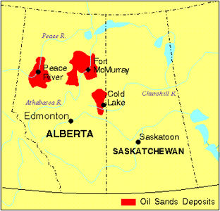
Article
Peace River, Alta, incorporated as a town in 1919, population 6744 (2011c), 6315 (2006c). The Town of Peace River is located near the confluence of the PEACE and Smoky rivers.
"https://d3d0lqu00lnqvz.cloudfront.net/media/media/9a26c61d-d249-4e98-9fe3-21c0199423c0.jpg" // resources/views/front/categories/view.blade.phphttps://d3d0lqu00lnqvz.cloudfront.net/media/media/9a26c61d-d249-4e98-9fe3-21c0199423c0.jpg
Article
Peachland, BC, incorporated as a district municipality in 1909, population 5200 (2011c), 4883 (2006c). The District of Peachland is located on the west shore of OKANAGAN LAKE, 25 km south of KELOWNA.
"https://d3d0lqu00lnqvz.cloudfront.net/media/media/ee63257d-2328-4e59-914e-6e496c640a51.jpg" // resources/views/front/categories/view.blade.phphttps://d3d0lqu00lnqvz.cloudfront.net/media/media/ee63257d-2328-4e59-914e-6e496c640a51.jpg

Article
The rural-agricultural environment includes the Short Hills, vineyards, orchards and Canada's oldest sugar maple tree. There are sand quarries on the Fonthill Kame.
"https://www.thecanadianencyclopedia.ca/images/tce_placeholder.jpg?v=e9dca980c9bdb3aa11e832e7ea94f5d9" // resources/views/front/categories/view.blade.phphttps://www.thecanadianencyclopedia.ca/images/tce_placeholder.jpg?v=e9dca980c9bdb3aa11e832e7ea94f5d9