Article
Kindersley
Kindersley, Sask, incorporated as a town in 1911, population 4678 (2011c), 4412 (2006c). The Town of Kindersley is located in west-central Saskatchewan, 200 km southwest of Saskatoon and 65 km east of the Alberta border.
Signing up enhances your TCE experience with the ability to save items to your personal reading list, and access the interactive map.
Create AccountArticle
Kindersley, Sask, incorporated as a town in 1911, population 4678 (2011c), 4412 (2006c). The Town of Kindersley is located in west-central Saskatchewan, 200 km southwest of Saskatoon and 65 km east of the Alberta border.
"https://www.thecanadianencyclopedia.ca/images/tce_placeholder.jpg?v=e9dca980c9bdb3aa11e832e7ea94f5d9" // resources/views/front/categories/view.blade.phphttps://www.thecanadianencyclopedia.ca/images/tce_placeholder.jpg?v=e9dca980c9bdb3aa11e832e7ea94f5d9

Article
Kingsville, Ont, incorporated as a town in 1901, population 21 362 (2011c), 20 908 (2006c). The Town of Kingsville amalgamated with the townships of Gosfield South and Gosfield North in 1998. Kingsville is located about 40 km southeast of WINDSOR, in Essex County on the north shore of Lake Erie.
"https://www.thecanadianencyclopedia.ca/images/tce_placeholder.jpg?v=e9dca980c9bdb3aa11e832e7ea94f5d9" // resources/views/front/categories/view.blade.phphttps://www.thecanadianencyclopedia.ca/images/tce_placeholder.jpg?v=e9dca980c9bdb3aa11e832e7ea94f5d9
Article
Kippens, NL, incorporated as a town in 1968, population 1815 (2011c), 1739 (2006c). The Town of Kippins is located on the west coast of Newfoundland to the west of STEPHENVILLE and overlooking St George's Bay.
"https://d3d0lqu00lnqvz.cloudfront.net/media/media/e2405cb4-4c61-42e3-9436-6f0c2ad15670.jpg" // resources/views/front/categories/view.blade.phphttps://d3d0lqu00lnqvz.cloudfront.net/media/media/e2405cb4-4c61-42e3-9436-6f0c2ad15670.jpg

Article
The town began with an edict by King Louis the XIV of France on 29 June 1711 which established the parish of St-Joachim de Pointe-Claire. A civil parish was established 11 years later on 3 March 1722. On 1 July 1845, the parish came under the control of the clergy.
"https://d3d0lqu00lnqvz.cloudfront.net/media/media/957abd37-5418-464b-9c53-740d485debeb.jpg" // resources/views/front/categories/view.blade.phphttps://d3d0lqu00lnqvz.cloudfront.net/media/media/957abd37-5418-464b-9c53-740d485debeb.jpg

Article
Kirkland Lake, Ont, incorporated as a town in 1972, population 8133 (2011c), 8248 (2006c). The Town of Kirkland Lake is located 241 km northwest of North Bay.
"https://www.thecanadianencyclopedia.ca/images/tce_placeholder.jpg?v=e9dca980c9bdb3aa11e832e7ea94f5d9" // resources/views/front/categories/view.blade.phphttps://www.thecanadianencyclopedia.ca/images/tce_placeholder.jpg?v=e9dca980c9bdb3aa11e832e7ea94f5d9
Article
Klondike (also spelled Klondyke). The name is derived from a Gwich'in word, thron-duick (hammer river), and identifies a town, a river, and a range of hills in the Yukon.
"https://www.thecanadianencyclopedia.ca/images/tce_placeholder.jpg?v=e9dca980c9bdb3aa11e832e7ea94f5d9" // resources/views/front/categories/view.blade.phphttps://www.thecanadianencyclopedia.ca/images/tce_placeholder.jpg?v=e9dca980c9bdb3aa11e832e7ea94f5d9
Article
First named Baye des Morues, or "bay of cod," by Jean Alphonse in the 1500s, it was referred to as malle baye (latin, "bad bay") by Samuel de CHAMPLAIN in 1608 for its difficult anchorage. Some of New France's first rural settlements were located in the area.
"https://d3d0lqu00lnqvz.cloudfront.net/media/media/e8e68977-8038-4c47-8ee4-2970a6e433c3.jpg" // resources/views/front/categories/view.blade.phphttps://d3d0lqu00lnqvz.cloudfront.net/media/media/e8e68977-8038-4c47-8ee4-2970a6e433c3.jpg

Article
Occupation of the present townsite started when Archdeacon John Alexander Mackay established a residential school and sawmill (1898). Not accessible by road until 1947, the largely Indigenous community grew very slowly for many years.
"https://www.thecanadianencyclopedia.ca/images/tce_placeholder.jpg?v=e9dca980c9bdb3aa11e832e7ea94f5d9" // resources/views/front/categories/view.blade.phphttps://www.thecanadianencyclopedia.ca/images/tce_placeholder.jpg?v=e9dca980c9bdb3aa11e832e7ea94f5d9
Article
HistoryFounded in 1917, it was one of the first agricultural centres to be settled when the transcontinental railway opened up the Abitibi region around 1910.
"https://www.thecanadianencyclopedia.ca/images/tce_placeholder.jpg?v=e9dca980c9bdb3aa11e832e7ea94f5d9" // resources/views/front/categories/view.blade.phphttps://www.thecanadianencyclopedia.ca/images/tce_placeholder.jpg?v=e9dca980c9bdb3aa11e832e7ea94f5d9
Article
La Tuque, Quebec, incorporated 1911, population 11,001 (2016 census), 11,227 (2011 census). La Tuque is located on the Rivière Saint-Maurice, 165 km north of Trois-Rivières. The town was built at the start of the 20th century at the site of a former trading post. It owes its name to a mountain shaped like a triangular woolen hat, popularly known as a “tuque.” The town’s economy is driven in large part by the forestry industry.
"https://www.thecanadianencyclopedia.ca/images/tce_placeholder.jpg?v=e9dca980c9bdb3aa11e832e7ea94f5d9" // resources/views/front/categories/view.blade.phphttps://www.thecanadianencyclopedia.ca/images/tce_placeholder.jpg?v=e9dca980c9bdb3aa11e832e7ea94f5d9
Article
Labrador City, Newfoundland and Labrador, incorporated as a town in 1961, population 7,220 (2016 census), 7,367 (2011 census). The Town of Labrador City is in western Labrador near the Quebec border.
"https://www.thecanadianencyclopedia.ca/images/tce_placeholder.jpg?v=e9dca980c9bdb3aa11e832e7ea94f5d9" // resources/views/front/categories/view.blade.phphttps://www.thecanadianencyclopedia.ca/images/tce_placeholder.jpg?v=e9dca980c9bdb3aa11e832e7ea94f5d9
Article
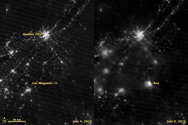
Lac-Mégantic, Quebec was incorporated as a town in 1907, population 5,747 (2021 census), 5,654 (2016 census). Located in Estrie in the Regional County Municipality of Le Granit, the town of Lac-Mégantic is situated approximately 95 km east of Sherbrooke on the northeast shore of Lac Mégantic (see Eastern Townships). The town is Le Granit’s centre of industry (lumber and granite), administration and commerce. On 6 July 2013, a devastating train derailment occurred in Lac-Mégantic (see Lac-Mégantic Rail Disaster; Railway Disasters).
"https://d3d0lqu00lnqvz.cloudfront.net/media/media/0ba32689-d18b-4fa5-924f-8d7008f7ca20.jpg" // resources/views/front/categories/view.blade.phphttps://d3d0lqu00lnqvz.cloudfront.net/media/media/0ba32689-d18b-4fa5-924f-8d7008f7ca20.jpg
Article
Agriculture sustained the early settlers, but the town developed through its close connection with the paper and textile industries.
"https://www.thecanadianencyclopedia.ca/images/tce_placeholder.jpg?v=e9dca980c9bdb3aa11e832e7ea94f5d9" // resources/views/front/categories/view.blade.phphttps://www.thecanadianencyclopedia.ca/images/tce_placeholder.jpg?v=e9dca980c9bdb3aa11e832e7ea94f5d9
Article
Lacombe, Alta, incorporated as a town in 1902 and as a city in 2010, population 11 707 (2011c), 10 752 (2006c). The City of Lacombe, the county seat for the County of Lacombe, is situated in rolling parkland some 118 km south of Edmonton.
"https://www.thecanadianencyclopedia.ca/images/tce_placeholder.jpg?v=e9dca980c9bdb3aa11e832e7ea94f5d9" // resources/views/front/categories/view.blade.phphttps://www.thecanadianencyclopedia.ca/images/tce_placeholder.jpg?v=e9dca980c9bdb3aa11e832e7ea94f5d9
Article
Ladysmith, BC, incorporated as a town in 1904, population 7921 (2011c), 7538 (2006c). The Town of Ladysmith is located on the east coast of VANCOUVER ISLAND, 85 km north of Victoria. It is located on Ladysmith Harbour on the northern edge of a lucrative farming area.
"https://www.thecanadianencyclopedia.ca/images/tce_placeholder.jpg?v=e9dca980c9bdb3aa11e832e7ea94f5d9" // resources/views/front/categories/view.blade.phphttps://www.thecanadianencyclopedia.ca/images/tce_placeholder.jpg?v=e9dca980c9bdb3aa11e832e7ea94f5d9