Share on Facebook
 Share on X
 Share by Email
 Share on Google Classroom
Torngat Mountains National Park (established in 2008) encompasses 9700 km2 of Labrador north of Saglek Fiord. Torngat - in Inuktitut, Torngait - refers to one of the most powerful of Inuit spirits believed to dwell in these mountains. For thousands of years, this place has been home to Inuit and their predecessors, and remains an Inuit homeland today.
The process of establishing this park began in 1969. It involved patience, perseverance, changing policies, changing circumstances, mutual respect and, most important, willingness of Inuit to consent to the creation of a National Park in their homeland.
Torngat Mountains National Park Reserve was officially established on 1 December 2005 when the Labrador Inuit Land Claims Agreement came into legal effect. Nunavik (northern Québec) Inuit also have rights and interests to the land and resources in this area. Their consent to the establishment of a national park is provided through the Nunavik Inuit Land Claims Agreement and the national park reserve transitioned to full national park status when this agreement took effect on 10 July 2008.
Natural History
Torngat Mountains National Park extends from Saglek Fiord to the very northern tip of Labrador; and from the provincial boundary with Québec in the west, to the Labrador Sea in the east. Within this area an 8.4 km2 inholding of Labrador Inuit Lands centered on Iron Strand Beach is the only significant parcel of land not included in the park. The park includes all coastal islands and islets in and north of Saglek Fiord, and all lands down to the low tide mark.
The park's biophysical setting strongly influences the climate and biota. With the Labrador Sea to the east, Hudson and Davis straits to the north and Ungava Bay to the west, there is a strong maritime influence. The coast is icebound through the winter, and pack ice may persist well into July and icebergs drift past on the Labrador Current all summer long. In addition to this marine influence, the Torngat Mountains are deeply incised by fjords and deep river valleys. Consequently, extreme bioclimatic gradients are the norm and lead to highly localized weather and ecological communities. While temperatures often reach 20º-30º C during summer, sub-zero temperatures, snow, and extreme winds can occur during any month.
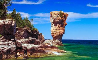
The Torngat Mountains are a geological showcase. A diversity of surficial features is clearly visible because of the limited vegetation cover and the sheer cliffs cutting through deep layers of rock. The oldest rocks in the park have been aged at more than 3.6 billion years old, and ensuing effects of plate tectonics, deposition, metamorphosis and glaciation have created a rich geological tapestry. The mountain range include many peaks exceeding 1200 m, including Mount Caubvick (known as Mont D'Iberville in Québec), which at 1652 m is the highest point in mainland Canada east of the Rocky Mountains. Evidence of glaciation is widespread; indeed more than 50 small glaciers still persist in deep cirques and are the only glaciers in continental North America not in the western mountains.
Torngat Mountains National Park lies just north of the treeline and is characterized by pronounced vegetation gradients. In sheltered valley bottoms in the southern half of the park relatively lush shrub thickets of willows and alders develop and some small stands of balsam poplar persist along Nakvak Brook. However, as one moves upslope these thickets rapidly give way to dwarf birch, prostrate shrubs and herbaceous tundra, and then to barren communities dominated by rock, lichens and moss in alpine zones. These zones creep down towards sea level as one moves further north, an effect that is exacerbated along the coast. Thus shrub thickets dwindle and disappear in the northern half of the park, and the extreme north is dominated by tundra and rock-lichen vegetation communities.
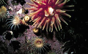
The park is at the limits of distribution for many wildlife species. Boreal species occupy the relatively lush vegetation in southern river valleys. Tundra species inhabit northern and highland sections of the park. Generally wildlife communities are typical of the low Arctic and include such species as Arctic fox, grey wolf, Arctic hare, caribou, and several species of northern voles and lemmings. However many boreal species such as black bears and red fox also inhabit the park. The extensive coastline also brings species associated with marine environments, most notably polar bears but also including several species of seals and whales. Large runs of arctic char connect the sea to the land and for centuries have provided an important food source for wildlife and Inuit alike.
Bird communities provide a strong sense that the park is a crossroads for wildlife. Several treeline species reach their northern range limits in thickets of tall shrubs in the southern half of the park; these include grey-cheeked thrush, blackpoll warbler, Wilson's warbler, American tree sparrow and fox sparrow. Conversely true Arctic species such as red-throated loon, ivory gull, snowy owl, rough-legged hawk and rock ptarmigan also breed in the area. The many sheltered bays and islands are important for seabirds such as black guillemot and glaucous gull, while high numbers of many species of waterfowl such as common and Barrow's goldeneye, American black duck, black scoter, common eider and Canada goose come to the northern Labrador coast in late summer to molt.
An Inuit Homeland
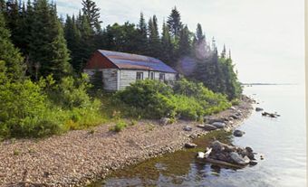
Inuit and their predecessors have occupied the Torngat Mountains for millennia, and archaeological sites, some of which are nearly 7000 years old are evident throughout the park. The chert quarry at Ramah Bay was a source of highly valued, glasslike stone used for making tools; Ramah chert was traded widely and has been found as far away as Newfoundland, New England and the Great Lakes. Evidence of more recent human use includes abandoned Moravian mission sites and Hudson's Bay Company trading posts, and a German meteorological station, which was deployed by U-boat at Martin Bay during the Second World War (see also U-Boat Operations).
Today the area continues to be used for hunting, fishing and travelling by Inuit and increasingly as a tourist destination by people from around the world. Though many Inuit elders were born and grew up in the area now included in the park, there is no contemporary year-round human occupancy in the park.
Park Management
The cornerstone of the relationship between Parks Canada and Inuit is a 7-member co-operative management board consisting of 2 members appointed each by Makivik Corporation (representing Nunavik Inuit), the Nunatsiavut Government (representing Labrador Inuit) and Parks Canada, with an independent chair jointly appointed by all 3 parties. The board's mandate is to advise the federal minister of Environment on all matters related to park management.
The administrative and visitor reception and orientation centre is in Nain, NL. A satellite office is located in Kangiqsualujjuaq, Nunavik, Qué. The Torngat Mountains Base Camp and Research Station, owned and operated by Inuit, is located adjacent to the southern boundary of the park and is a gateway to the park. Activities include hiking and backpacking, mountain climbing, participating in guided expeditions or tours, and exploring cultural and human history.