Share on Facebook
 Share on X
 Share by Email
 Share on Google Classroom

Course

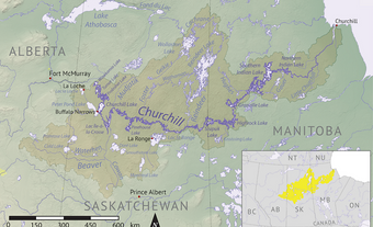
The Red River begins at the confluence of the Bois de Sioux and Otter Tail rivers and flows north, creating the border between Minnesota and North Dakota. It then passes through Fargo and Grand Forks, North Dakota and is joined by the Pembina River just south of the Canadian border before reaching Emerson, Manitoba. Between Emerson and Winnipeg, the Red River flows through a rich agricultural area, is joined by the Roseau River, and passes through St. Jean Baptiste, Morris, Ste. Agathe and St. Adolphe. It then flows through the urban environment of Winnipeg, where it is joined by the Assiniboine River — the Red’s largest tributary — before returning to an agricultural region and flowing through Lockport and Selkirk on its way to Lake Winnipeg where it drains. Its course is meandering, with numerous oxbow lakes formed along the way. (An oxbow lake begins as a river curve that eventually gets cut off, becoming a lake as the river finds a shorter course.)
Flora and Fauna
The Red River is located in a temperate grassland region; however, much of the natural landscape has been converted for agricultural purposes. The land adjacent to the river is home to willow, cottonwood, American elm, Manitoba maple, green ash, bur oak and basswood. Bluestem, switchgrass, Indian grass, quaking aspen, rough fescue and oak can be found on the surrounding prairie. Mussels, clams, snails, crayfish, walleye, northern pike, channel catfish, burbot, common carp, bass and crappie inhabit the river in addition to salamanders, snapping turtles, western painted turtles, three species of frog (wood, boreal chorus and northern leopard), muskrats and beavers. Great blue herons, belted kingfishers, ducks, geese, golden eagles, bald eagles, falcons and hawks are common migratory birds. The surrounding prairie is home to white-tailed deer, rabbits and ground squirrels.
Environmental Concerns
Water quality is a concern in the Red River,and is affected by both natural (e.g., sediment) and human (e.g., contaminants) substances. The river supplies drinking water to municipalities in southern Manitoba, Minnesota and North Dakota, as well as water for industrial and agricultural activities (e.g., irrigation). As a result of human activities in these regions, the Red River contains higher than normal concentrations of nitrogen and phosphorus, which enter the river through agricultural and urban runoff (e.g., fertilizers, feed lots, lawn fertilizers and household chemicals). High phosphorus concentrations have led to eutrophication (enhanced plant growth and decreased dissolved oxygen) in upstream lakes and wetlands, which has negative consequences for water quality and ecosystem diversity. Air pollution, as well as discharge of treated municipal sewage, also contribute to poor water quality. In one instance an accidental release of untreated sewage in September 2002 in Winnipeg led to high levels of fecal coliform upstream and in Lake Winnipeg.
The Red River has a lot of suspended sediment, particularly when floods erode the river banks. Because sediment acts as a repository for certain chemicals released into the environment, too much exposure to sediment can be harmful to aquatic species. Moreover, sediment makes the water more difficult to treat for human consumption. Contaminants bind to the suspended particles, or hide behind them, making it more difficult for water treatment plants to kill pathogens.
Flooding


The Red River is prone to severe flooding, particularly during the spring as snow melts and river ice breaks up. Major floods in 1826 and 1852 both contributed to the destruction of the original Upper Fort Garry (Winnipeg). Since then, severe flooding has occurred in 1861, 1950, 1966, 1974,1979, 1996, 1997, 2006, 2009 and 2011. The 1997 flood was termed the “flood of the century,” as it was the largest flooding event in 145 years. In Manitoba, it created a flooded area of about 2,000 km2 (dubbed “the Red Sea” by the media) and caused more than $500 million worth of damage.
Evidence indicates that both the magnitude and frequency of flooding has increased. Numerous small communities have constructed ring dykes to reduce the risk of damage due to flooding, and, in 1968, the city of Winnipeg built the Red River Floodway, which diverts floodwaters east around the city. The floodway was instrumental in mitigating the effects of flooding in Winnipeg during the 2009 and 2011 floods.
History
For thousands of years before contact with Europeans, the Red River basin in what is now Manitoba was inhabited by the Sioux and Saulteaux (an Ojibwa people). The Red River and its tributaries were significant to transportation,trade and fishing,while the surrounding land was important for hunting and ceremonial activities. Archaeological evidence indicates early attempts at agriculture near Lockport in the early 1400s, and fishing and trading camps at the confluence of the Assiniboine and Red rivers, commonly known as the Forks, dating back 6,000 years.
Prior to European exploration of the Red River, the Sioux, Saulteaux, and neighbouring Cree were in contact with Europeans through trade at York Factory, a post on Hudson Bay, south of the Nelson River Delta. Trade came closer to home for these First Nations groups when, under the direction of Pierre Gaultier de Varennes, Sieur de La Vérendrye, Fort Maurepas was built near the mouth of the Red River (1734) and Fort Rouge was built at the Forks (1738). These forts were soon abandoned, but with the establishment of Fort Gibraltar in 1809 (later Upper Fort Garry), the Forks remained an important hub for transportation and trade. In 1812, the Red River Colony — a settlement encompassing the length of the Red River — was established by Thomas Douglas, 5th Earl of Selkirk. As Europeans continued to colonize the Red River Valley, the Métis population grew. In 1869, Louis Riel led the Métis resistance at Upper Fort Garry, formed a government, and created the province of Manitoba.(See also Métis Settlements, Red River Rebellion.)