Share on Facebook
 Share on X
 Share by Email
 Share on Google Classroom
Nunavut covers 1,936,113 km2 of land and 157,077 km2 of water in Northern Canada, representing 21 per cent of the country’s total area. The territory includes part of the mainland, most of the Arctic Archipelago, and all of the islands in Hudson Bay, James Bay and Ungava Bay. Nunavut is divided by three of Canada’s seven physiographic regions. These regions are the Hudson Bay Lowlands, the Canadian Shield and the Canadian Arctic.

Physiographic Regions
The Hudson Bay Lowlands are a sedimentary basin in the middle of the Canadian Shield. This region includes Southampton Island and Coats Island in Hudson Bay.
The Canadian Shield comprises much of the mainland, certain islands around Hudson Bay and parts of the Arctic Archipelago. The lowlands of the Canadian Shield rest on a bed of rock that is at least 1 billion years old. They are covered by a thin layer of soil, and are often poorly drained and flat. A defining characteristic of this physiographic region are the thousands of lakes and rivers that dot the surface. Baffin Island represents the eastern rim of the Canadian Shield and is classified as a highland. Its landscape includes rolling plateau surfaces interrupted by glacial troughs.
The Canadian Arctic physiographic region extends throughout the northern half of Nunavut. The region contains the Arctic Coastal Plains, Arctic Lowlands and the Innuitian Region of the High Arctic. Nunavut also includes most of Canada’s Arctic Archipelago. Within its archipelagic territory, Nunavut contains five of the world’s 30 largest islands. These islands are Baffin (the largest island in Canada and fifth largest in the world), Ellesmere, Devon, Axel Heiberg and Prince of Wales. Victoria and Melville islands, also among the largest 30 islands in the world, are split between Nunavut and the Northwest Territories. The Archipelago is divided into northern and southern halves by the Parry Channel, which runs from Lancaster Sound on the eastern fringe to M’Clure Strait. The eastern edge of the Archipelago is a mountainous zone, with elevations approaching 2,000 m in the north, and a heavily fjorded coast. The ice caps that occupy the highest land on many of these islands contain the largest glaciers in Canada. In sharp contrast, the central and western islands are relatively flat, with low relief. On the northern islands, night lasts for 24 hours during the winter months, while day lasts for 24 hours during the summer.
Geology

Nunavut is divided into three geological regions. These regions are the Innuitian Orogen in parts of the northern Arctic Archipelago, the Canadian Shield and the Interior Platform. The Innuitian Orogen, which lies primarily in the northern half of the Archipelago, is made up of folded and gently dipping sedimentary rock. This area is composed of the Franklin Basin and the Sverdrup Basin. Both these basins have been accumulating sedimentary deposits for 500 million years. The Canadian Shield region contains some of the oldest igneous, metamorphic and sedimentary rocks on Earth. These rocks are between one and four billion years old. The Interior Platform region encompasses most of the southern half of the Archipelago. It is covered in rocks from the Cambrian to the Cenozoic era (as old as 542 million years).
Mineral and hydrocarbon resources are abundant throughout Nunavut. The territory contains proven reserves of oil and gas, diamonds, gold, tin, uranium, iron ore, zinc, lead, rock salt, gypsum and other base metals. The Sverdrup Basin alone is thought to contain over 481 billion cubic metres of recoverable gas.
Surface

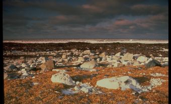
Much of the land in Nunavut is characterized as tundra, which is bare, rocky and treeless. The soil of the tundra is locked in permafrost. In Nunavut permafrost extends anywhere from a few metres to 1,500 m into the ground. Only a thin layer of the tundra thaws during the summer months. During this period, the ground is soggy and covered in marshes, lakes, bogs and streams. Moving northward in the Archipelago, the tundra progressively changes into polar desert as the climate becomes increasingly drier and colder.
Water
Nunavut contains 21 per cent of Canada’s freshwater within its rivers, streams and lakes. The Arctic Archipelago has a land to water ratio of 1:1. It is characterized by many channels, ranging in depth from less than 100 m to more than 600 m in eastern Lancaster Sound. The dominant characteristic of the water in these channels is the seasonal to multiyear cover of sea ice. This sea ice can be several metres thick. Sea ice coverage is complete in winter throughout the Archipelago. However, several recurring polynyas (areas of open water surrounded by sea ice) provide exceptions. The largest polynya is in northern Baffin Bay.
Climate
The climate varies across Nunavut’s vast territory. The entire region, however, experiences long, cold winters and cool summers. Nunavut is the coldest and driest part of Canada. Annual precipitation is very low. Large parts of the Archipelago, especially the northern half, receive only 100 to 200 mm of precipitation a year. This classifies it as polar desert. On Baffin Island, the average annual temperature may be as low as -20°C in the north and -6°C in the south. In Kugluktuk, the warmest community in Nunavut, the temperature can sometimes reach 30°C in the summer, with winter ranging from -15°C to -40°C. In contrast, Grise Fiord is Nunavut’s coldest community. Here, temperatures infrequently reach above 0 and frequently drop to −50°C in the winter. Spring temperatures are more consistent throughout the territory, with average daytime highs between -20°C and -10°C.
The Arctic is experiencing climate warming faster and more intensely than most other parts of the world. Changes in Nunavut include higher temperatures, melting permafrost, reduced sea ice, thinning and retreating glaciers and diminished ice shelves. These changes threaten polar bears, seals, walruses, caribou and many other species on which traditional Inuit harvesting practices depend. Melting permafrost is also having a negative impact on housing and infrastructure throughout Nunavut.
Vegetation and Wildlife

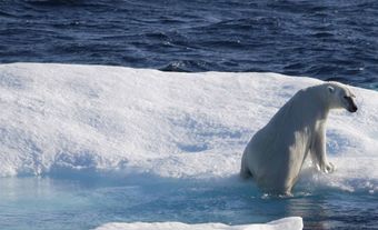
A wide array of flora and fauna can be found across Nunavut. There are no trees in the territory. However, other vegetation survives in Nunavut’s shallow soil. This vegetation includes dwarf shrubs, grasses, mosses, lichens and about 200 species of flowering plants. Nunavut is also home to dozens of land mammals. These mammals include polar bear, Peary caribou, barren-ground caribou, muskox, Arctic fox, Arctic wolf, Arctic hare, wolverine and lemming. The territory is also home to over 100 species of birds, most of which are migratory species. These birds include auks, buntings, ducks, geese, cranes, loons, plovers, sandpipers and terns. Only the raven, snowy owl and ptarmigan spend the entire year in Nunavut. In addition, Nunavut’s waters are rich in mammals and fish. Aquatic mammals that live in the waters of the Archipelago include walrus, ringed seals, bearded seals, beluga, narwhal, bowhead and various other species of whale.
National and Territorial Parks

As of 2015, 12 per cent of the territory, including both land and water, are protected (236,621 km2). Nunavut has five national parks, covering 110,364 km2. The five parks are Auyuittuq National Park, Quttinirpaaq National Park, Sirmilik National Park, Ukkusiksalik National Park and Qausuittuq National Park. The territory also has protected area sites, national wildlife areas, territorial parks, conservation and historic sites and wildlife sanctuaries. Currently, Lancaster Sound has been proposed as a National Marine Conservation Area.