Share on Facebook
 Share on X
 Share by Email
 Share on Google Classroom
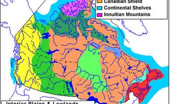
Manitoba is divided by three of Canada’s seven physiographic regions. These three regions are the Hudson Bay Lowland, the Canadian Shield and the Interior Plains. Most of Manitoba’s population is concentrated in the southeastern corner of the province, in the Interior Plains physiographic region. This region is also where most of Manitoba’s arable land is located. By comparison, the Hudson Bay Lowland and the Canadian Shield are generally not suitable for agriculture. Churchill, Manitoba’s only saltwater port, is located in the Hudson Bay Lowland. Hydroelectric power, freshwater fishing, metal mines and some forestry are located in the Canadian Shield region.

Geology
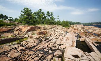
The bedrock underlying the province varies from ancient Precambrian rock to young sedimentary rock. The Precambrian rock is between 4.6 billion to 542 million years old. By comparison, the sedimentary rock dates from the Paleozoic to Cenozoic era (542 to 66 million years old). The Precambrian rock forms part of the Canadian Shield — some of the oldest rock on Earth. It consists principally of granites and granite gneisses in contact with volcanic rocks and ancient, metamorphosed sedimentary rocks. Contact zones often contain valuable minerals, including nickel, lead, zinc, copper, gold and silver. All of these minerals are mined in Manitoba.

Over top of the Precambrian rock is sedimentary rock. During the last ice age, a large, glacial lake called Lake Agassiz was located in south-central Manitoba. The surface of the lowland created by this lake is made up of sediment on top of rocks formed during the Ordovician, Silurian and Devonian periods. Rocks from these periods range from 485 to 359 million years old. These rocks are mined for limestone, gypsum, clay, bentonite, sand and gravel. Petroleum has also been found in rocks formed during the Carboniferous period (359 to 299 million years ago).
Lakes and Rivers
Manitoba’s principal resource is fresh water. Of Canada’s 10 provinces, Manitoba ranks third in water coverage. Lakes and rivers make up 101,590 km2 of the province, comprising one-sixth of its total area. The largest lakes are Winnipeg (24,387 km2), Winnipegosis (5,374 km2) and Manitoba (4,624 km 2). All three are the remnants of Lake Agassiz.
Since Southern Manitoba is lower than the regions to the west, east and south, the major rivers of Western Canada flow into it. These rivers include the Saskatchewan, Red, Assiniboine and Winnipeg rivers. Lakes Winnipeg, Manitoba and Winnipegosis receive the combined flow of these drainage basins. In turn, the water drains into Hudson Bay via the Nelson River. These river systems, together with the Churchill, Hayes and other rivers, are sources of hydroelectricity. Today, Lake Winnipeg is the only body of water used for commercial transportation. However, the Hayes, Nelson, Winnipeg, Red and Assiniboine rivers were important during the fur trade and early settlement eras.

Flooding along the Red River and its principal tributaries, the Souris and Assiniboine, has affected towns as well as large expanses of agricultural land. The flood in April and May 1997 was the most severe since 1852. An estimated 1,000 homes were damaged, and 7,000 military personnel were called in to help with evacuation and relocation. The Red River Floodway, originally built in 1968, was expanded following the 1997 flood. The floodway protects Winnipeg in the event of a major flood. Similar diversions, dams and dikes are in place to protect other communities.
Climate

Manitoba is located in the upper middle latitudes (49° N to 60° N) and at the heart of a continental landmass. Because of its location, Manitoba experiences large annual temperature ranges. Winters are very cold and summers are moderately warm. In the winter, Manitoba receives a southward sweep of cold, dry, Arctic and maritime polar air. The winter is followed by mild, humid, maritime tropical air in summer. Nearly two-thirds of Manitoba’s precipitation occurs during the six summer months. The remainder of the province’s precipitation is mostly snow.
Spring comes first to the Red River Valley and spreads to the north and west. Snowfall tends to be heaviest in the east and diminishes westward. Around Winnipeg the average snowfall is 126 cm per year. Fortunately, 60 per cent of Manitoba’s annual precipitation falls in May, June and July. These months are the peak growing period for grains. Late August and early September are dry, favouring the harvest of cereal grains.
Vegetation

Southern Manitoba is open grassland and aspen. In the centre is mixed forest. To the north is boreal forest and bush-tundra by Hudson Bay. In the south, high evaporation rates discourage the growth of trees, which are replaced by prairie. Both tall-grass and mixed-grass species were extensive before settlement. Elm, ash and Manitoba maple grow along streams, and oak grows on dry sites. Toward the centre of the province there is less evaporation. Here, mixed broadleaf forest replaces parkland.
The boreal forest in the northern half of Manitoba consists of white and black spruce, jack pine, larch, aspen and birch.
The boreal forest continues with decreasing density nearly to the shores of Hudson Bay. Here, cold summers and short growing periods discourage all but stunted growth of trees. Vegetation in this part of Manitoba is mainly spruce, willow and tundra types of moss, lichens and sedges.
Soil

In general, the types of soil found in Manitoba correspond with the distribution of natural vegetation. The most productive soil is called chernozem. This black-coloured soil is found in the once-dominant prairie grassland of the Red River Valley and southwestern Manitoba.
In areas of transition to mixed forest, degraded black soils and grey-wooded soils are common. Large areas of the former Lake Agassiz, where drainage is poor, are termed “degraded rendzina.” The term rendzina refers to the high concentration of lime carbonate in the soil. Soils derived from the hard granites and other rocks of the Canadian Shield are described as grey-wooded, podsol and peat.
National and Provincial Parks
Manitoba has 92 provincial parks and two national parks — Riding Mountain and Wapusk. At 8,310 km2, Sand Lakes Wilderness Park is Manitoba’s largest provincial park. Others include Whiteshell Provincial Park in the southeast corner of the province, featuring the rugged terrain of the Canadian Shield; Turtle Mountain Provincial Park in the southwest, created to protect the marshland and deciduous forest of the region; and Grass River Provincial Park in the west, close to the midpoint of the province’s western boundary, home to wild caribou, moose and bear.