Share on Facebook
 Share on X
 Share by Email
 Share on Google Classroom
City
In Canada "city" is a broad, generic term usually referring to an urbanized area. The size of this area, its economic base, social character and form of local government may be different in each province or territory because Municipal Government derives its authority from the provincial legislature, and in each province the conditions that must exist before an area may be classified as a city differ. As a result, it is simpler to examine the process of Urbanization itself, defined as the generation and spread of characteristic features of urban life.
The demographic trend toward urbanization in Canada began well before Confederation and still continues at a rapid pace. Today, 80% of Canadians live in urban areas, meaning cities, towns, villages or unincorporated settlements with populations greater than 1000 persons, or in built-up fringes of incorporated areas.
Historical Development to 1920
Great empires with dynamic metropolitan centres such as Paris and London expanded by establishing colonial outposts. Early Canadian colonial towns were part of this large-scale phenomenon and served as agents of the urban metropolitan centres. Economically, they exploited the colony's staples; culturally, they transmitted the metropolitan-centre style of life to a new frontier; militarily and administratively they were often the means of occupying and holding the colony.
The colonial towns were generally entrepôts, collecting staples (eg, fur, fish, minerals or wheat) from the region for shipment to the metropolitan centre, where the final processing was done and from which the manufactured foods were, in turn, distributed. French and British colonial towns preceded the general settlement of a region and constituted an urban frontier, but the growth and prosperity of the colonial towns depended on the potential of their hinterlands.
Initially the towns acted as a channel for a region's development and contained a high proportion of the colony's population. Decentralization began as the town's proportion of the total population dropped, even though the towns tended to grow rapidly. The new, smaller, secondary centres developed a degree of autonomy during this second phase because of their isolation in a prerailway era and because the primary town of the region did not yet have the necessary facilities to dominate all aspects of life in the hinterland. This decentralization process was reversed when colonial towns such as Quebec City, Montreal, Toronto and Halifax became major urban centres.
Colonial towns, primarily connected and concerned with the overseas metropolis, lacked significant connections with other colonial towns, even with those of their own region. The beginning of regional and inter-regional connections represented the end of the colonial phase and the beginning of the commercial era, as towns began to produce goods and services not only for themselves but for the entire region.
By 1851, the 9 largest cities - Montréal, Québec City, Saint John, Toronto, Halifax, Hamilton, Kingston, Ottawa and London - had developed into dynamic commercial centres and had won considerable hegemony over sizable hinterlands.
The modern Canadian city emerged between 1851 and 1921, although in most respects the changes in the first 30 years after 1851 were relatively minor. Toronto replaced Québec City as Canada's second-largest city (after Montréal), and several manufacturing towns in southern Ontario increased their population to almost 10 000 (Guelph, St Catherines, Brantford, Belleville), forming a second tier of cities.
By the 1880s, however, Canada's 2 largest cities, Montréal and Toronto, began to outdistance their nearest rivals in importance. Equally dramatic was the rapid growth of western cities, led by Winnipeg and Vancouver, followed by that of 2 other young giants, Calgary and Edmonton, developments which signalled the relative decline of Québec City and Kingston in central Canada and of Saint John and Halifax in the Atlantic provinces.
To some extent rapid urban growth and stagnation can be attributed to the aggressiveness of local Elites. Winnipeg's business elite was crucial to that city's rise to metropolitan status, while the local leadership in many Atlantic cities faltered in critical periods; but more important were the vagaries of international markets in staples, and government and corporate decisions. These factors were beyond the control of individual cities.
International political events stimulated the growth of Montréal's export trade and Toronto's successful competition with Montréal over the use of American trade routes. The policies of the federal government on tariffs and railways strengthened the growth of manufacturing in central cities and led to a simultaneous weakening of industry in the Maritimes. The Canadian Pacific Railway decided to run its main line through Winnipeg and created a number of new communities, including Vancouver.
Technological change was also important. The conversion from wood and sail to iron and steam undercut a major shipbuilding industry in Québec City and Saint John, and resulted in a shift from an Atlantic to a continental economy.
In their pursuit of metropolitan status, most Canadian cities passed through several stages of development: colonial entrepôt, commercial town, commercial-industrial city and diversified metropolis. Although all cities did not, of course, develop systematically in some deterministic fashion, Canada's urban development can nevertheless be distinguished by particular eras, and all cities and towns, regardless of scale, function and regional location, were shaped to a great extent by each era.
The Contemporary City
Since 1920, Canadian cities have entered a phase dominated by the technology of the automobile and the truck, an economic orientation away from industry to service functions and to dramatic spatial decentralization of population and activities. City-building, however, is a cumulative process. The pre-1920 city is still the core of the modern, dispersed metropolis.
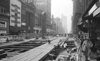
The distinction between modern developments and those of earlier periods is usually very clear and can be identified on any street map. The street systems of urban cores are set out on grids. Surrounding these urban cores are more recent suburban developments with curvilinear street systems. Many of the tensions in contemporary cities derive from the struggle for coexistence between parts of the city built before WWII and those built afterwards. As economic activity has shifted from industry to the service sector, the change has been reflected in building styles as office towers push factories to cheaper land at the urban fringe.
Transportation facilities - streets, expressways and public transit lines - are crucial to the functioning of modern cities and often occupy 25-30% of urban land. Residential housing uses a slightly larger percentage of urban land, followed by industry and office buildings. These land uses represent outward expansion, as the city captures and incorporates more and more farmland, and upward expansion, as the downtown area expands with high-rise buildings that greatly intensify land use for both commercial and residential purposes.
Suburbs
The new portion of any city is usually known as the suburb. The suburbs of 1910 in Toronto, Vancouver, Montréal or Halifax are now considered to be part of the central city core, and the suburban additions of the 1920s are now integrated into the main area of the city proper. Shortly after 1945, however, the development of suburbs changed significantly. E.P. Taylor amassed 2000 acres (809.4 ha) of farmland on the outskirts of Toronto and developed a new town called Don Mills which, because of its scale, design and distinctive character, changed suburban development.
Each of the 4 neighbourhoods into which it was divided centered or focused on a school. The curvilinear road system was used not only to discourage through traffic, but to allow roads to follow the topography. Houses of 1½ storeys were set broadside to the street on large lots. Residential densities (at 25 units per ha) were half of standard densities. Land uses in each neighbourhood were deliberately separated.
Space was allocated for a shopping centre, and single family dwellings were separated from apartment buildings, offices and industrial space. Don Mills was considered so successful, both financially and socially, that the model was repeated throughout Canada until the late 1970s.
Urban Renewal
After 1945, urban renewal schemes were attempted by all levels of government (federal, provincial and municipal) to try to improve the housing conditions in city cores (see Urban Reform). Most politicians and planners believed that urban renewal - involving the expropriation of homes and businesses, the clearing of land and the building of new (often public) housing - would revitalize the edges of the downtown and make this housing more acceptable to those who were migrating to the suburbs.
Massive urban renewal schemes met with stiff resistance from the displaced working-class families. Owners of expropriated property did not receive enough compensation to purchase a similar house elsewhere. Tenants complained that their lives were being uprooted and good housing was being demolished. Small businesses were destroyed.
The basic objection to urban renewal came from people who had a different idea of their communities from that of the city planners and politicians. These residents argued strongly that the urban renewal program was wrong-headed because Canadian cities did not have the slums of American cities and that the 3 levels of government were replacing viable neighbourhoods with concrete jungles.
The struggles over public urban renewal continued until the late 1960s, when after massive outcries in Vancouver, Winnipeg and Toronto, the federal government finally agreed to stop funding the public urban renewal program. Since then more modest attempts to revitalize the city have included improved street lighting, neighbourhood parks, decorative sidewalks and community centres.
Public authorities were not responsible for all urban renewal. The private development industry responded to the vastly increased housing needs of young Canadians by building large apartment buildings, usually where handsome 19th-century houses had been demolished as city councils had approved yet another rezoning. Neighbourhood groups were formed in reaction to the destruction of neighbourhoods, and in every Canadian city these groups had running battles with the developers and city hall (see Urban Citizen Movements; City Politics).
By the mid-1970s, as the apartment boom ended, mainly for economic reasons, cities began developing policies to strengthen downtown communities, rather than trying to obliterate them.
Cityscape
The image of most Canadian cities is defined by the downtown, where tall office towers have now replaced smokestacks. Buildings are usually similar in design, reflecting the fact that development companies are among the largest of Canadian-owned corporations. The natural settings of most Canadian cities are now secondary in importance to the downtown, and in many cases even difficult to identify.
The explosive growth of cities since WWII has resulted in the destruction of much of Canada's urban heritage. Considerable political energy has been spent saving what remains of 19th-century buildings from the ravages of the latter half of the 20th century.
By the end of the 1970s, city officials, developers and the public were ready to admit that more interesting buildings could be built and more attractive streetscapes could be designed, and most cities began to take steps to improve the downtown areas. These changes have certainly improved an otherwise bleak central city, but have done little to make the scale of cities human again.
By the late 1980s there was a new approach to the cityscape that focused on the interrelationship between the natural and the built environment. Growing out of the environmental movement, citizens and policy makers began to discuss urban ecology and to plan the built environment in new and innovative ways. The widely agreed upon goal was to begin to plan urban places in sustainable ways that preserved many aspects of the natural environment. Progress toward urban sustainability has been slow but it is clear that urban ecology - like urban heritage - will be a major and important issue in the coming decade.
Social Context and Diversity
Until 1945, most Canadian cities grew by immigration from northwest Europe, but since the 1950s this pattern has given way to a far more diversified set of origins. In 1957, 95% of immigrants were from Europe or the US. The proportion of immigrants coming from those countries has decreased so by 2006, 83.9% of the immigrants who arrived between 2001 and 2006 were born in regions other than Europe. By 2006, for example, the "visible minority" population made up 42.9% of the 5.1 million people in the Toronto region. Their arrival has enriched Canadian cities immeasurably but has coincided with other pressures on jobs and the provision of public services, leading inevitably to some stresses and social problems.
These trends indicate that the Canadian city is diverse and that there is a dynamic set of processes at work. Cities, to survive, are continually remaking themselves. To understand them is a continuing challenge.