Share on Facebook
 Share on X
 Share by Email
 Share on Google Classroom

The Alaska boundary dispute took place between Canada and the United States over the boundary of southeastern Alaska and the coast of British Columbia. The contested area, known as the Alaska Panhandle, is a complex coastal area consisting of large fjords and channel islands. The dispute was resolved by an international tribunal in 1903. ( See also Northwest Coast.)
Early History
The eastern border of the Alaska Panhandle was never firmly established throughout the period of Russian colonization (c. 1780s to 1867), nor in the first few decades of American control.
Throughout the late 18th and early 19th century, Russian explorers, whalers and traders travelling east across the Bering Sea had settled along coastal Alaska, claiming the area as the eastern frontier of the Russian Empire. The Panhandle was an especially attractive region, given its abundant stocks of fish and sea otters — at that time the most valuable animal in the European fur trade.
The presence of British and American explorers also grew throughout this period, adding to a European presence in the region that increasingly encroached on the traditional territories of the Łingít (Tlingit) and Haida peoples.
(courtesy Native Land Digital / Native-Land.ca)
In 1825, the Russian and British governments signed the Treaty of Saint Petersburg, which set the southern coastal border of the Panhandle at 54°40’ N latitude (near the modern town of Prince Rupert, BC). The treaty was focused on the coastal area and did not firmly set the Panhandle’s eastern boundary, because the interior region was extremely mountainous and not seen as a priority to the negotiators. However, the text of the agreement stated that “the line of coast which is to belong to Russia… shall be formed by a line parallel to the winding of the coast, and which shall never exceed the distance of ten marine leagues [56 km] therefrom.”
Alaska Purchase
On 30 March 1867, the United States bought the entire region from Russia. The Alaska Purchase (as it’s called) occurred at a strategic moment for both countries. Following the Crimean War between Russia and Britain in the 1850s, Russia feared that Alaska would be easily conquered by the British in the event of a future war, and was therefore interested in cutting its potential losses by selling the territory. In the 1840s, the United States had rapidly secured holdings along the Pacific coast, from California to British Columbia. Some American officials hoped that Washington may even claim British Columbia, at that time still a British colony.
As the purchase was completed, the Canadian colonies in the east were in negotiations toward Confederation — a process that was completed on 1 July 1867. Four years later, on 20 July 1871, British Columbia joined Canada, thereby ending American aspirations for full control of the Pacific coast north of Tijuana, Mexico (see Northwest Coast).
Shortly afterward, Ottawa petitioned Washington for a survey of the Panhandle area to determine the exact location of the border, but Washington rejected the idea on the grounds that it would be too costly an investment for such a peripheral tract of land.
Klondike Gold Rush and Arbitration
The Klondike gold rush, which began in fall 1897, brought the smouldering dispute to a head. Canada wanted a direct route from the Klondike gold fields to the Pacific fjords, whereas the US wanted to maintain control of the intervening territory.


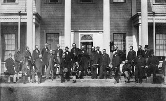
A joint commission attempted to resolve the dispute in 1898–99 and failed. The problem was then referred to an international tribunal in 1903, whose members included three American politicians (Elihu Root, Henry Cabot Lodge and George Turner), two Canadians (Sir Allen Bristol Aylesworth and Sir Louis-Amable Jetté) and Lord Alverstone, Lord Chief Justice of England.
The Canadian and American representatives favoured their respective governments’ territorial claims. Based on the 1825 Treaty of Saint Petersburg, it was clear that the border should lie 56 km east of the ocean coast, but it was not clear how the ocean coast should be defined. The Americans argued that the coast should be defined as the point where the mainland touches Pacific water, whereas the Canadians argued that the coast was at the western boundary of the channel islands.
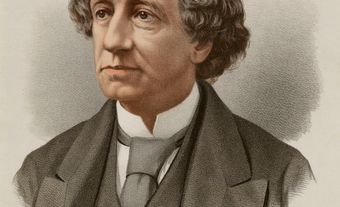
To the Canadians’ chagrin, Alverstone supported the American claim. Furious with what they saw as a betrayal by their colonial government, the Canadian representatives refused to sign the final decision. However, this act of protest did not prevent the decision from taking effect, since the question had been put to binding arbitration. When the resolution was issued on 20 October 1903, a strong wave of anti-British feeling erupted in Canada.
Significance and Legacy
Though Canada lost the Alaska boundary dispute, the event marked a significant moment in which the country began to distinguish its political interests from both Britain and the United States. Canadians’ frustration with the American victory may, for instance, have contributed to their rejection of free trade with the US in the 1911 “reciprocity election.”

More importantly, the dispute enhanced Canadians’ desire for full control over their foreign policy. Irritated at the decision, Prime Minister Sir Wilfrid Laurier asserted that Canada's lack of treaty-making power made it difficult to maintain its rights internationally. He took no immediate action to rectify this problem, but the dispute nonetheless supported Ottawa’s case for increasing independence from London in the years following the First World War.