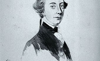
James Cook, explorer (born 27 October 1728 near Marton, England; died on 14 February 1779 at Kealakekua Bay, Sandwich Islands, Hawaii). The greatest navigator of his era, Cook served as master of the Pembroke at the siege of Louisbourg (1758) during the Seven Years' War.

Contributions to Cartography
James Cook charted part of Gaspé and helped prepare the map that enabled James Wolfe's armada to navigate the St. Lawrence River. He was a painstaking surveyor, and was chiefly responsible 1763-67 for mapping the intricate and treacherous coast of Newfoundland, which England acquired at the end of the war; he had charted part of its east shore in 1762, including St. John's harbour. Cook revolutionized Europe's knowledge of the South Pacific in his great circumnavigations of 1768-71 and 1772-75.
Voyages in North America
In July 1776 he began a third voyage, to search for a Northwest Passage. He sailed east across the Pacific and anchored in Nootka Sound, on Vancouver Island (29 March 1778). His men repaired his ships and carried on a lucrative trade with the Nootka (Nuu-chah-nulth) for otter pelts. He departed 26 April 1778 and sailed into Bering Strait in search of the passage, retreating in the face of a wall of ice. He was killed in the Sandwich Islands in an altercation with the local people.
Cook was not the first to explore the Northwest Coast, but he and his men were the first to reveal its attractions, particularly the fur trade. Among those who followed was George Vancouver, who had sailed with Cook on his second and third voyages.


 Share on Facebook
 Share on X
 Share by Email
 Share on Google Classroom


