
Browse "Places"
-
Article
Madawaska: A Canadian-American Borderland, from Colonization to Division
Madawaska was a borderland that comprised parts of New Brunswick, Lower Canada, and the state of Maine, concentrated along the upper Saint John River valley.
"https://d3d0lqu00lnqvz.cloudfront.net/media/media/0052e055-bf0b-4980-8f10-08f926f15b9b.jpg" // resources/views/front/categories/view.blade.php
https://d3d0lqu00lnqvz.cloudfront.net/media/media/0052e055-bf0b-4980-8f10-08f926f15b9b.jpg
-
Article
Magog
In 1888 the village of Magog separated from the municipality of Magog Township (established 1855) and soon incorporated as a town.
"https://thecanadianencyclopedia.ca/images/tce_placeholder.jpg?v=e9dca980c9bdb3aa11e832e7ea94f5d9" // resources/views/front/categories/view.blade.php
https://thecanadianencyclopedia.ca/images/tce_placeholder.jpg?v=e9dca980c9bdb3aa11e832e7ea94f5d9
-
Article
Mahone Bay
Mahone Bay, NS, incorporated as a town in 1919, population 943 (2011c), 904 (2006c). The Town of Mahone Bay is located on the "Lighthouse Route" of Nova Scotia's southern shore, 10 km northwest of LUNENBURG.
"https://thecanadianencyclopedia.ca/images/tce_placeholder.jpg?v=e9dca980c9bdb3aa11e832e7ea94f5d9" // resources/views/front/categories/view.blade.php
https://thecanadianencyclopedia.ca/images/tce_placeholder.jpg?v=e9dca980c9bdb3aa11e832e7ea94f5d9
-
Article
Mailhot-Curran Archaeological Site
The Mailhot-Curran Site is an ancient Iroquoian village located in the municipality of Saint-Anicet in southwestern Québec, about 70 km upstream from Montreal.
"https://d3d0lqu00lnqvz.cloudfront.net/media/media/55eeeb66-e2b1-4c62-a2c6-51acc259b3fa.jpg" // resources/views/front/categories/view.blade.php
https://d3d0lqu00lnqvz.cloudfront.net/media/media/55eeeb66-e2b1-4c62-a2c6-51acc259b3fa.jpg
-
Article
Main River
From its 4 headwater lakes (called Four Ponds - lakes are called "ponds" in Newfoundland and Labrador) in the Long Range Mountains on Newfoundland and Labrador's Great Northern Peninsula, the Main River drops quickly over boulder-strewn rapids.
"https://thecanadianencyclopedia.ca/images/tce_placeholder.jpg?v=e9dca980c9bdb3aa11e832e7ea94f5d9" // resources/views/front/categories/view.blade.php
https://thecanadianencyclopedia.ca/images/tce_placeholder.jpg?v=e9dca980c9bdb3aa11e832e7ea94f5d9
-
Article
Maisie Hurley
Maisie Hurley, née Maisie Amy Campbell-Johnston, Vancouver-area political activist, Indigenous ally (see Indigenous Peoples in Canada), newspaper founder and art collector (born 27 November 1887 in Swansea, Wales; died 3 October 1964 in North Vancouver, British Columbia). Although Hurley had no formal legal training or law degree (see Legal Education), she worked on several legal cases and advocated for Indigenous peoples’ basic human rights as well as for changes to the Indian Act. In 1946, Hurley started a newspaper called The Native Voice that aimed to bring attention to important issues concerning Indigenous communities across Canada (see Rights of Indigenous Peoples in Canada). In 2011, Hurley’s collection of Indigenous art was displayed at the North Vancouver Museum.
"https://d3d0lqu00lnqvz.cloudfront.net/Untitled-11.jpg" // resources/views/front/categories/view.blade.php
https://d3d0lqu00lnqvz.cloudfront.net/Untitled-11.jpg
-
Article
Maison Saint-Gabriel
Maison Saint-Gabriel is a museum and historic site that opened in 1966. This 300-year-old building, located in Montreal’s Pointe-Sainte-Charles district, is one of the finest examples of the traditional architecture of New France. It served, notably, as a home for the Filles du Roi.
"https://d3d0lqu00lnqvz.cloudfront.net/media/media/73821ef9-7927-4c50-87a8-505b99c36529.jpg" // resources/views/front/categories/view.blade.php
https://d3d0lqu00lnqvz.cloudfront.net/media/media/73821ef9-7927-4c50-87a8-505b99c36529.jpg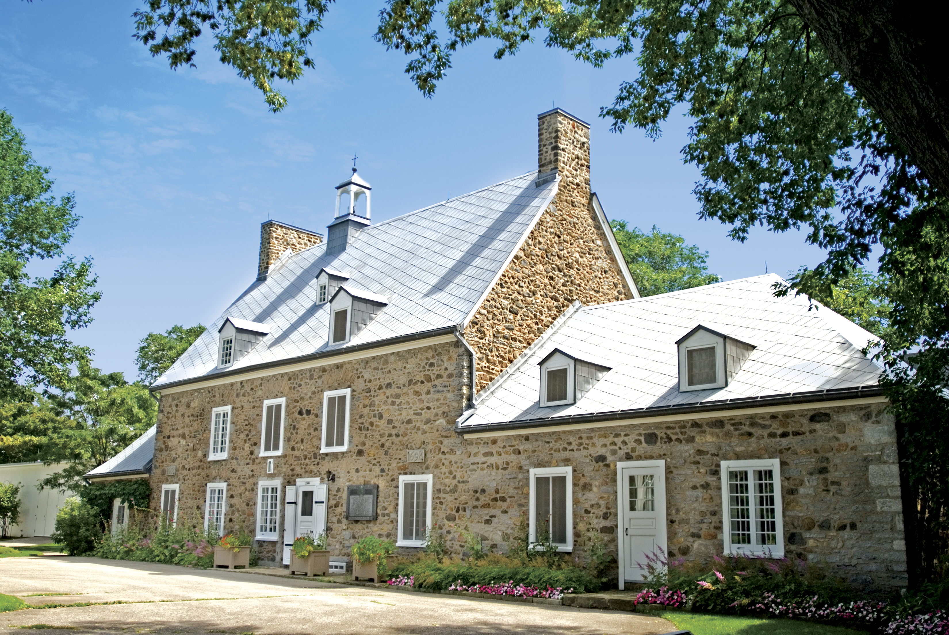
-
Article
Malartic
Malartic, Qué, Town, pop 3640 (2006c), 3704 (2001c), inc 1939. Malartic is located 70 km east of ROUYN-NORANDA in northwestern Québec. It was established by Québec's Ministry of Mines, which hoped to end the
"https://thecanadianencyclopedia.ca/images/tce_placeholder.jpg?v=e9dca980c9bdb3aa11e832e7ea94f5d9" // resources/views/front/categories/view.blade.php
https://thecanadianencyclopedia.ca/images/tce_placeholder.jpg?v=e9dca980c9bdb3aa11e832e7ea94f5d9
-
Article
Malpeque Bay
Malpeque Bay is a picturesque bay so deeply indented into the northeast coast of Prince Edward Island that its southern edge lies within 7 km of the south coast of the Island.
"https://thecanadianencyclopedia.ca/images/tce_placeholder.jpg?v=e9dca980c9bdb3aa11e832e7ea94f5d9" // resources/views/front/categories/view.blade.php
https://thecanadianencyclopedia.ca/images/tce_placeholder.jpg?v=e9dca980c9bdb3aa11e832e7ea94f5d9
-
Article
Mandeville and Lanoraie Archaeological Sites
The Mandeville and Lanoraie archaeological sites are located downstream from Montreal.
"https://d3d0lqu00lnqvz.cloudfront.net/media/media/ba39944f-720c-4075-bfd3-9d7823ef5a3f.jpg" // resources/views/front/categories/view.blade.php
https://d3d0lqu00lnqvz.cloudfront.net/media/media/ba39944f-720c-4075-bfd3-9d7823ef5a3f.jpg
-
Article
Manitoba
Manitoba is a Canadian province located at the centre of the country, bounded by Saskatchewan to the west, Hudson Bay and Ontario to the east, Nunavut to the north, and North Dakota and Minnesota to the south. The province was founded on parts of the traditional territories of the Cree, Anishinaabe, Oji-Cree, Dakota/Lakota (Sioux) and Dene peoples, and on the homeland of the Métis Nation. The land is now governed treaties 1, 2, 3, 4, 5, 6 and 10. As of the 2021 census, Manitoba had 1,342,153 residents, making it the fifth most populous province or territory in Canada. Manitoba joined Confederation in 1870, and its capital city, Winnipeg, was incorporated shortly thereafter, in 1873.
"https://d3d0lqu00lnqvz.cloudfront.net/media/media/05379a18-2309-44ac-a09c-17602a71a3da.jpg" // resources/views/front/categories/view.blade.php
https://d3d0lqu00lnqvz.cloudfront.net/media/media/05379a18-2309-44ac-a09c-17602a71a3da.jpg
-
Timelines
Manitoba
Sometimes referred to as the “keystone” province because of its position in the centre of the country, Manitoba is bounded by Nunavut and Hudson Bay to the north, Ontario to the east, the United States to the south and Saskatchewan to the west.
"https://d3d0lqu00lnqvz.cloudfront.net/media/media/631b3ba1-7b69-4d3b-9c8f-68ec97fdfdfb.jpg" // resources/views/front/categories/view.blade.php
https://d3d0lqu00lnqvz.cloudfront.net/media/media/631b3ba1-7b69-4d3b-9c8f-68ec97fdfdfb.jpg
-
Article
Centennial Concert Hall
The Centennial Concert Hall is a performing arts centre located on Main Street in Winnipeg, Manitoba. It opened in in 1968 and is owned by the province and operated by the Manitoba Centennial Centre Corporation.
"https://d3d0lqu00lnqvz.cloudfront.net/centennialconcerthall/centennialconcerthall.jpg" // resources/views/front/categories/view.blade.php
https://d3d0lqu00lnqvz.cloudfront.net/centennialconcerthall/centennialconcerthall.jpg
-
Article
Manitoba Escarpment
The Manitoba Escarpment is an approximately 675 km-long ridge that lies mainly within the southwest corner of Manitoba and extends into east-central Saskatchewan and northeastern North Dakota, United States (see Escarpments in Canada). The portion that extends into the United States is also known as the Pembina Escarpment. The Escarpment hosts the highest elevation points in Manitoba and divides the Canadian Prairies into the First and Second Prairie levels. Several of Manitoba’s most rare and famous fossils have been discovered along the Manitoba Escarpment from marine Cretaceous bedrock exposures between 66 and 120 million years old. Today, the varied topography, soils and microclimates of the Escarpment host a diverse community of plant and animal life, including several at-risk species.
"https://d3d0lqu00lnqvz.cloudfront.net/manitobaescarpment/Pembina-Hills.jpg" // resources/views/front/categories/view.blade.php
https://d3d0lqu00lnqvz.cloudfront.net/manitobaescarpment/Pembina-Hills.jpg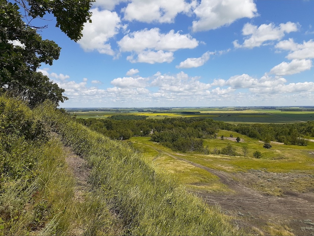
-
Article
Manitoulin Island
Manitoulin Island, 2,765 km2, the largest island in the world located in a lake, is part of an archipelago at the top of Lake Huron straddling the Ontario-Michigan border. Its northern shore encloses the North Channel, which leads to the St. Mary's River at Sault Ste Marie. An extension of the Niagara Peninsula, Manitoulin Island has an irregular, rocky shoreline and many interior lakes.
"https://d3d0lqu00lnqvz.cloudfront.net/media/media/1162b2df-38f0-4b14-9524-61846e90f575.jpg" // resources/views/front/categories/view.blade.php
https://d3d0lqu00lnqvz.cloudfront.net/media/media/1162b2df-38f0-4b14-9524-61846e90f575.jpg