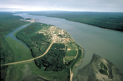
Browse "Places"
-
Article
Fort McMurray
Fort McMurray, Alberta, unincorporated population centre, population 61,374 (2011c), 47,705 (2006c). Fort McMurray is the largest community in the Regional Municipality of Wood Buffalo (RMWB). It is technically known as the municipality’s “Urban Service Area” and colloquially known as “Fort Mac.” The community located near the confluence of the Athabasca and Clearwater rivers in northeastern Alberta, near the centre of the vast Athabasca oil sands deposit. Originally incorporated as a city in 1980, in 1995 Fort McMurray merged with much of the surrounding area — collectively known as Improvement District No. 143 — to create the RMWB. At 63,783 km2, the municipality is the largest in North America in terms of size, accounting for nearly 10 per cent of the province’s total area. In May 2016, Fort McMurray experienced one of the worst forest fires in Canadian history. More than 80,000 residents were evacuated and approximately 2,400 structures — about 10 per cent of the city — were destroyed.
"https://d3d0lqu00lnqvz.cloudfront.net/media/media/c51a0711-1d24-48e1-9267-7117eaa2eb47.jpg" // resources/views/front/categories/view.blade.php
https://d3d0lqu00lnqvz.cloudfront.net/media/media/c51a0711-1d24-48e1-9267-7117eaa2eb47.jpg
-
Article
Fort McPherson
Fort McPherson, Northwest Territories, population 647 (2021). The hamlet of Fort McPherson is located on the right bank of the Peel River, on the Dempster Highway. It is west of the Mackenzie River and east of the Richardson Mountains. Fort McPherson is called Teetł’it Zheh (“head of the waters-town”) in Gwich’in, an Athapaskan language (see Indigenous Languages in Canada). The hamlet is home to the Teetł’it Gwich’in First Nation (“people of the headwaters”). Fort McPherson is one of four communities in the Gwich’in Settlement Region. The region is an area created by the Gwich’in Comprehensive Land Claim Agreement (1992). The other three communities in the region are Aklavik, Tsiigehtchic and Inuvik.
"https://d3d0lqu00lnqvz.cloudfront.net/media/new_article_images/FortMcPherson/FortMcPhersonDog.jpg" // resources/views/front/categories/view.blade.php
https://d3d0lqu00lnqvz.cloudfront.net/media/new_article_images/FortMcPherson/FortMcPhersonDog.jpg
-
Article
Fort Michilimackinac
Fort Michilimackinac is located on the south side of the Straits of Mackinac. It sits on a sand beach in the northernmost extension of the Lower Peninsula of Michigan. Michilimackinac was the second fort to guard the Straits of Mackinac. The fort was a key trade, military, and diplomatic post for the French (1715–61) and the British (1761–81). The fort’s buildings were moved by the British in 1780-1 to a more defensible location on Mackinac Island. Fort Michilimackinac was reconstructed in the 20th century and serves as a living history museum in Michigan.
"https://d3d0lqu00lnqvz.cloudfront.net/Michilimackinac/Michilimackinac-State-Park-buildings.jpg" // resources/views/front/categories/view.blade.php
https://d3d0lqu00lnqvz.cloudfront.net/Michilimackinac/Michilimackinac-State-Park-buildings.jpg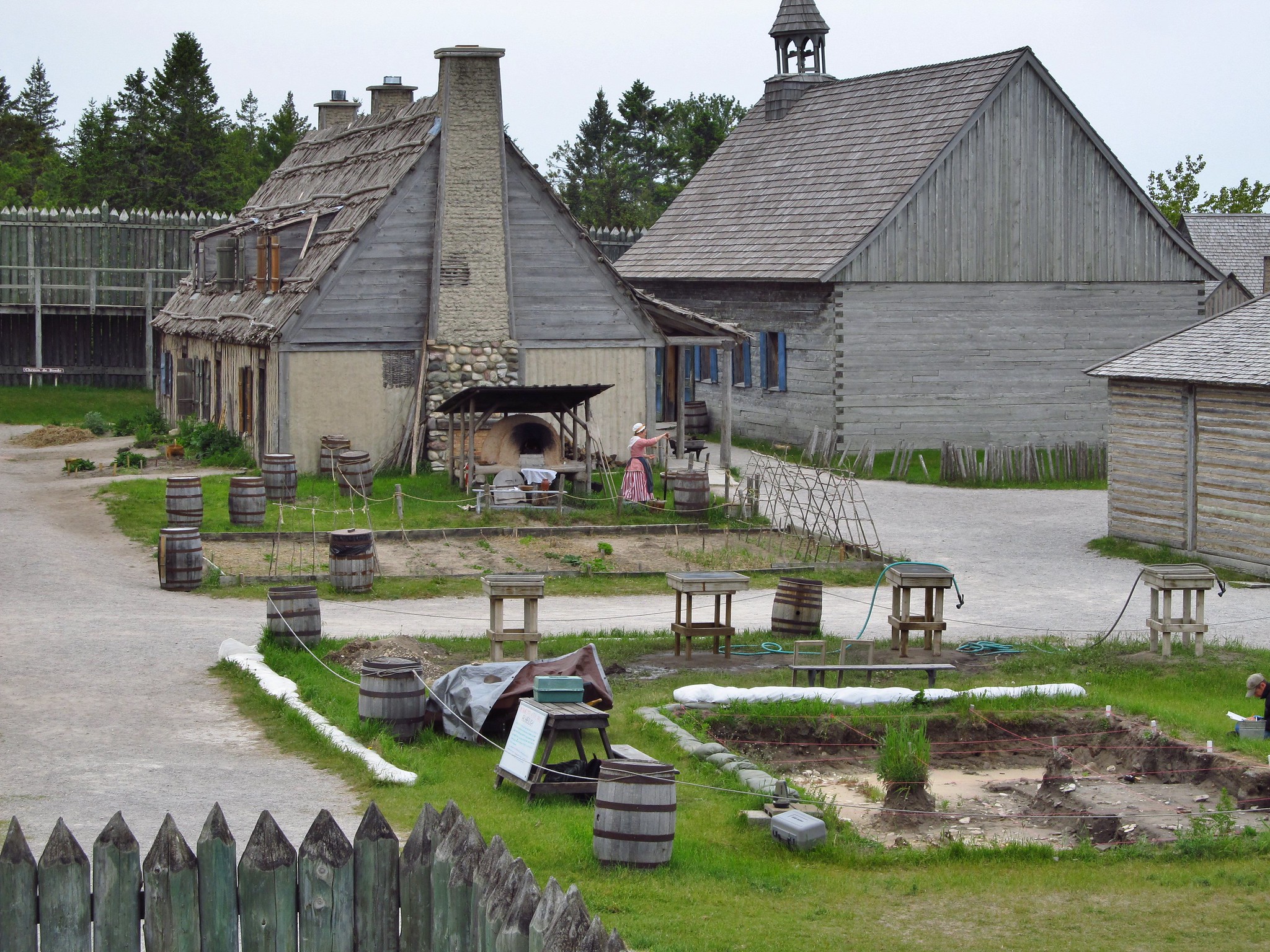
-
Article
Fort Mississauga National Historic Site of Canada
Fort Mississauga National Historic Site, located in NIAGARA-ON-THE-LAKE, Ont, was designated as a national historic site in 1931 by the Historic Sites and Monuments Board of Canada. The British built Fort Mississauga between 1813 and 1823 to guard the mouth of the NIAGARA RIVER.
"https://thecanadianencyclopedia.ca/images/tce_placeholder.jpg?v=e9dca980c9bdb3aa11e832e7ea94f5d9" // resources/views/front/categories/view.blade.php
https://thecanadianencyclopedia.ca/images/tce_placeholder.jpg?v=e9dca980c9bdb3aa11e832e7ea94f5d9
-
Article
Fort Nelson
Fort Nelson, BC, population centre, population 2,611 (2021 census), 3,371 (2016 census). Fort Nelson is the service centre for the Northern Rockies Regional Municipality (NRRM). The NRRM is made up of a number of communities, of which Fort Nelson is the largest. Fort Nelson is located in the northeast corner of British Columbia, near the confluence of three rivers: Muskwa, Prophet and Sikanni Chief. Together these rivers combine to become the Fort Nelson River. The community is 387 km north of Fort St. John. It was named after British Admiral Horatio Nelson, famous for the Battle of Trafalgar. Incorporated as a town in 1987, Fort Nelson became a part of the NRRM in 2009.
"https://thecanadianencyclopedia.ca/images/tce_placeholder.jpg?v=e9dca980c9bdb3aa11e832e7ea94f5d9" // resources/views/front/categories/view.blade.php
https://thecanadianencyclopedia.ca/images/tce_placeholder.jpg?v=e9dca980c9bdb3aa11e832e7ea94f5d9
-
Article
Fort Niagara
Fort Niagara is situated on the east side of the Niagara River at Lake Ontario north of Youngstown, New York. It was built by the French in 1726–27 and surrendered to the British in 1759 during the Seven Years’ War. Fort Niagara was a major British supply depot during the American Revolution but was later transferred to the United States. It was an important American staging area during the War of 1812 but was captured by the British in 1813. Today it is a New York State historic site.
"https://d3d0lqu00lnqvz.cloudfront.net/media/media/659c26df-741b-477d-8d28-b5a7c4212206.jpg" // resources/views/front/categories/view.blade.php
https://d3d0lqu00lnqvz.cloudfront.net/media/media/659c26df-741b-477d-8d28-b5a7c4212206.jpg
-
Article
Fort Pitt
Founded in 1830, Fort Pitt was the major Hudson's Bay Company trading post between Forts Edmonton and Carlton (Saskatchewan), located at a large bend in the North Saskatchewan River just east of the modern Alberta-Saskatchewan border.
"https://d3d0lqu00lnqvz.cloudfront.net/media/media/2a58e580-6da4-4fd4-b1fe-dc1357c14c36.jpg" // resources/views/front/categories/view.blade.php
https://d3d0lqu00lnqvz.cloudfront.net/media/media/2a58e580-6da4-4fd4-b1fe-dc1357c14c36.jpg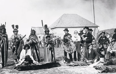
-
Article
Fort Providence
Fort Providence, NWT, incorporated as a hamlet in 1987, population 734 (2011c), 727 (2006c). The Hamlet of Fort Providence is located on the northeast bank of the MACKENZIE RIVER, 233 km southwest of YELLOWKNIFE.
"https://thecanadianencyclopedia.ca/images/tce_placeholder.jpg?v=e9dca980c9bdb3aa11e832e7ea94f5d9" // resources/views/front/categories/view.blade.php
https://thecanadianencyclopedia.ca/images/tce_placeholder.jpg?v=e9dca980c9bdb3aa11e832e7ea94f5d9
-
Article
Fort Qu'Appelle
The Cree and Saulteaux signed Treaty 4 at this site in 1874, and a year later a North-West Mounted Police outpost was established near the present townsite.
"https://d3d0lqu00lnqvz.cloudfront.net/media/media/da0840cf-ea67-4b6e-8a75-62b89d517d96.jpg" // resources/views/front/categories/view.blade.php
https://d3d0lqu00lnqvz.cloudfront.net/media/media/da0840cf-ea67-4b6e-8a75-62b89d517d96.jpg
-
Article
Fort Reliance
Fort Reliance, YT, is an abandoned post, established in 1874, located on the east bank of the YUKON RIVER, 13 km downstream from DAWSON. It remained the centre of the FUR TRADE and mining on the upper Yukon River for more than a decade.
"https://thecanadianencyclopedia.ca/images/tce_placeholder.jpg?v=e9dca980c9bdb3aa11e832e7ea94f5d9" // resources/views/front/categories/view.blade.php
https://thecanadianencyclopedia.ca/images/tce_placeholder.jpg?v=e9dca980c9bdb3aa11e832e7ea94f5d9
-
Article
Fort Resolution
Fort Resolution, NWT, incorporated as a hamlet in 2010, population 474 (2011c), 484 (2006c). The Hamlet of Fort Resolution is located on the south shore of GREAT SLAVE LAKE, 153 air km south of Yellowknife.
"https://thecanadianencyclopedia.ca/images/tce_placeholder.jpg?v=e9dca980c9bdb3aa11e832e7ea94f5d9" // resources/views/front/categories/view.blade.php
https://thecanadianencyclopedia.ca/images/tce_placeholder.jpg?v=e9dca980c9bdb3aa11e832e7ea94f5d9
-
Article
Fort Saint-Pierre
Fort Saint-Pierre is a French trading post spanning the years c. 1632 to 1669. It is situated on the southeastern shore of Cape Breton Island, in the village of St. Peters, on the Atlantic coast of a narrow isthmus separating the inland waterway of Lake Bras D'or from the open ocean.
"https://d3d0lqu00lnqvz.cloudfront.net/media/media/53e44654-9a96-4878-852f-9637b47db180.jpg" // resources/views/front/categories/view.blade.php
https://d3d0lqu00lnqvz.cloudfront.net/media/media/53e44654-9a96-4878-852f-9637b47db180.jpg
-
Article
Fort Saskatchewan
Fort Saskatchewan, Alberta, incorporated as a city in 1985, population 24,149 (2016 census), 19,051 (2011 census). The city of Fort Saskatchewan is located northeast of Edmonton, on the prairie parklands along to the North Saskatchewan River.
"https://thecanadianencyclopedia.ca/images/tce_placeholder.jpg?v=e9dca980c9bdb3aa11e832e7ea94f5d9" // resources/views/front/categories/view.blade.php
https://thecanadianencyclopedia.ca/images/tce_placeholder.jpg?v=e9dca980c9bdb3aa11e832e7ea94f5d9
-
Article
Fort Selkirk
The trading post was short-lived; it shut down in the summer of its establishment after it was attacked and plundered by the Chilkat. In 1898-99 the site was the base of the YUKON FIELD FORCE. A private trading post was established by Arthur Harper around 1890.
"https://d3d0lqu00lnqvz.cloudfront.net/media/media/ed5cd90d-59e6-4f79-98c0-9d447f907a0b.jpg" // resources/views/front/categories/view.blade.php
https://d3d0lqu00lnqvz.cloudfront.net/media/media/ed5cd90d-59e6-4f79-98c0-9d447f907a0b.jpg
-
Article
Fort Simpson
Fort Simpson, Northwest Territories (NWT), incorporated as a village in 1973, population 1,202 (2016 census), 1,238 (2011 census). The Hamlet of Fort Simpson is located on an island at the confluence of the Mackenzie and Liard rivers, 378 air km southwest of Yellowknife.
"https://d3d0lqu00lnqvz.cloudfront.net/media/media/4f133fe0-0529-435c-859e-7fc144a682c6.jpg" // resources/views/front/categories/view.blade.php
https://d3d0lqu00lnqvz.cloudfront.net/media/media/4f133fe0-0529-435c-859e-7fc144a682c6.jpg