Article
South Porcupine
South Porcupine, ON, one of five wards in the city of Timmins. Incorporated in 1911, South Porcupine became a part of Timmins in 1973. The town is named for an island in a local river reportedly shaped like a porcupine.
Signing up enhances your TCE experience with the ability to save items to your personal reading list, and access the interactive map.
Create AccountArticle
South Porcupine, ON, one of five wards in the city of Timmins. Incorporated in 1911, South Porcupine became a part of Timmins in 1973. The town is named for an island in a local river reportedly shaped like a porcupine.
"https://d3d0lqu00lnqvz.cloudfront.net/media/media/32e4c070-eeb8-4b20-83d5-b09fd6ad1241.jpg" // resources/views/front/categories/view.blade.phphttps://d3d0lqu00lnqvz.cloudfront.net/media/media/32e4c070-eeb8-4b20-83d5-b09fd6ad1241.jpg

Article
Spaniard's Bay, NL, incorporated as a town in 1965, population 2622 (2011c), 2540 (2006c). The Town of Spaniard's Bay is located north of Bay Roberts on the west side of Conception Bay.
"https://www.thecanadianencyclopedia.ca/images/tce_placeholder.jpg?v=e9dca980c9bdb3aa11e832e7ea94f5d9" // resources/views/front/categories/view.blade.phphttps://www.thecanadianencyclopedia.ca/images/tce_placeholder.jpg?v=e9dca980c9bdb3aa11e832e7ea94f5d9

Article
Spirit River, Alta, incorporated as a town in 1951, population 1025 (2011c), 1148 (2006c). The Town of Spirit River is located in the middle of a large prairie 78 km north of GRANDE PRAIRIE.
"https://www.thecanadianencyclopedia.ca/images/tce_placeholder.jpg?v=e9dca980c9bdb3aa11e832e7ea94f5d9" // resources/views/front/categories/view.blade.phphttps://www.thecanadianencyclopedia.ca/images/tce_placeholder.jpg?v=e9dca980c9bdb3aa11e832e7ea94f5d9
Article
Springdale, NL, incorporated as a town in 1965, population 2907 (2011c), 2764 (2006c). The Town of Springdale is located on the northwest side of Halls Bay near the mouth of the Indian River.
"https://www.thecanadianencyclopedia.ca/images/tce_placeholder.jpg?v=e9dca980c9bdb3aa11e832e7ea94f5d9" // resources/views/front/categories/view.blade.phphttps://www.thecanadianencyclopedia.ca/images/tce_placeholder.jpg?v=e9dca980c9bdb3aa11e832e7ea94f5d9
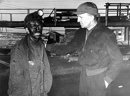
Article
Springhill, NS, incorporated as a town in 1889, population 3868 (2011c), 3941 (2006c). The Town of Springhill, located in the heart of Cumberland County on the Chignecto Isthmus.
"https://d3d0lqu00lnqvz.cloudfront.net/media/media/10dac7dd-3569-432a-8cb3-c5ad5f082f3f.jpg" // resources/views/front/categories/view.blade.phphttps://d3d0lqu00lnqvz.cloudfront.net/media/media/10dac7dd-3569-432a-8cb3-c5ad5f082f3f.jpg
Article
St. Alban's, NL, incorporated as a town in 1964, population 1233 (2011c), 1278 (2006c). The Town of St Alban's is located at the mouth of Bay D'Espoir on the south coast of Newfoundland.
"https://d3d0lqu00lnqvz.cloudfront.net/media/media/b429c854-8e79-4688-9843-8158c819faa1.jpg" // resources/views/front/categories/view.blade.phphttps://d3d0lqu00lnqvz.cloudfront.net/media/media/b429c854-8e79-4688-9843-8158c819faa1.jpg

Article
St Anthony, NL, incorporated as a town in 1945, population 2418 (2011c), 2476 (2006c). The Town of St Anthony is located near the top of the Northern Peninsula.
"https://www.thecanadianencyclopedia.ca/images/tce_placeholder.jpg?v=e9dca980c9bdb3aa11e832e7ea94f5d9" // resources/views/front/categories/view.blade.phphttps://www.thecanadianencyclopedia.ca/images/tce_placeholder.jpg?v=e9dca980c9bdb3aa11e832e7ea94f5d9
Article
St George's, NL, incorporated as a town in 1965, population 1207 (2011c), 1246 (2006c). The Town of St George's is located on the southeast side of St George's Bay, on the west coast of Newfoundland.
"https://www.thecanadianencyclopedia.ca/images/tce_placeholder.jpg?v=e9dca980c9bdb3aa11e832e7ea94f5d9" // resources/views/front/categories/view.blade.phphttps://www.thecanadianencyclopedia.ca/images/tce_placeholder.jpg?v=e9dca980c9bdb3aa11e832e7ea94f5d9
Article
St Lawrence, NL, incorporated as a town in 1949, population 1244 (2011c), 1349 (2006c). The Town of St Lawrence is located in the southeast corner of Newfoundland on the Burin Peninsula.
"https://d3d0lqu00lnqvz.cloudfront.net/media/media/b7a47460-85e0-4234-bcc2-659dcd61fad9.jpg" // resources/views/front/categories/view.blade.phphttps://d3d0lqu00lnqvz.cloudfront.net/media/media/b7a47460-85e0-4234-bcc2-659dcd61fad9.jpg

Article
The CANADA COMPANY had the area surveyed in 1839. The first settlers were attracted to the community in the 1840s because its location on the banks of the 2 watercourses meant water power to run various mills.
"https://www.thecanadianencyclopedia.ca/images/tce_placeholder.jpg?v=e9dca980c9bdb3aa11e832e7ea94f5d9" // resources/views/front/categories/view.blade.phphttps://www.thecanadianencyclopedia.ca/images/tce_placeholder.jpg?v=e9dca980c9bdb3aa11e832e7ea94f5d9
Article
St. Paul, Alberta, incorporated as a town in 1936, population 5,827 (2016 census), 5,405 (2011 census). The town of St. Paul, county seat for the county of St. Paul, is located on the north shore of Upper Thérien Lake, about 200 km northeast of Edmonton.
"https://d3d0lqu00lnqvz.cloudfront.net/media/media/d98dfd00-9c91-4c5d-bdbe-d68a2a98ce2e.jpg" // resources/views/front/categories/view.blade.phphttps://d3d0lqu00lnqvz.cloudfront.net/media/media/d98dfd00-9c91-4c5d-bdbe-d68a2a98ce2e.jpg
Article
St. Stephen, New Brunswick, incorporated as a town in 1973, population 4,415 (2016 census), 4,817 (2011 census). The town of St. Stephen is located on the St. Croix River in southwestern New Brunswick. First incorporated as a town in 1871, in 1973 St. Stephen was amalgamated with nearby Milltown (incorporated 1878) to form St. Stephen-Milltown. The incorporated name of St. Stephen has been used since 1975.
"https://www.thecanadianencyclopedia.ca/images/tce_placeholder.jpg?v=e9dca980c9bdb3aa11e832e7ea94f5d9" // resources/views/front/categories/view.blade.phphttps://www.thecanadianencyclopedia.ca/images/tce_placeholder.jpg?v=e9dca980c9bdb3aa11e832e7ea94f5d9
Article
Sainte-Anne-de-Beaupré, Quebec, constituted as a town in 1973, population 2,888 (2021 census), 2,880 (2011 census). The town has an area 62.64 km2 and is located on the north shore of the St. Lawrence River, 35 km east of Québec City. The town of Sainte-Anne-de-Beaupré is known worldwide for its Basilica of Sainte-Anne-de-Beaupré, a national shrine and pilgrimage site attracting over one million visitors and pilgrims annually. On 28 July 2022, Pope Francis celebrated mass at the basilica as part of his Apostolic Journey to Canada.
"https://d3d0lqu00lnqvz.cloudfront.net/media/media/81c8f2b9-c8a4-426f-ace2-e07cf5b82ea7.mov" // resources/views/front/categories/view.blade.phphttps://d3d0lqu00lnqvz.cloudfront.net/media/media/81c8f2b9-c8a4-426f-ace2-e07cf5b82ea7.mov

Article
Ste-Marie, Qué, Town, pop 11 320 (2001c), 10 966 (1996c), 10 513 (1991cA), 9536 (1986c), area 107.20 km2, inc 1855, is located on the Rivière CHAUDIÈRE. Situated on lowlands suitable for agriculture, it was built on part of the seigneury given in 1736 to Thomas-Jacques Taschereau.
"https://www.thecanadianencyclopedia.ca/images/tce_placeholder.jpg?v=e9dca980c9bdb3aa11e832e7ea94f5d9" // resources/views/front/categories/view.blade.phphttps://www.thecanadianencyclopedia.ca/images/tce_placeholder.jpg?v=e9dca980c9bdb3aa11e832e7ea94f5d9
Article
Stellarton, Nova Scotia, was incorporated as a town in 1889 and has a population of 4,485 (2011). It borders the East River, approximately 18 km southeast of Pictou.
"https://www.thecanadianencyclopedia.ca/images/tce_placeholder.jpg?v=e9dca980c9bdb3aa11e832e7ea94f5d9" // resources/views/front/categories/view.blade.phphttps://www.thecanadianencyclopedia.ca/images/tce_placeholder.jpg?v=e9dca980c9bdb3aa11e832e7ea94f5d9