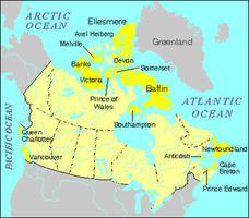
Victoria Island, NWT and Nunuvut, 217 291 km2. Victoria Island, the second-largest island in Canada, lies in the ARCTIC ARCHIPELAGO directly north of the arctic mainland. It is surrounded by Amundsen Gulf to the west, Viscount Melville Sound to the north and M'Clintock Channel to the east. BANKS ISLAND lies across the narrow Prince of Wales Strait in the northwest. Most of the western half of Victoria Island, except for the southern coast, is in the Northwest Territories. The remainder of the island is in Nunavut.
Geology
Victoria Island is largely composed of sedimentary rock. There is a belt of Precambrian rock on the west coast and another on the south coast, veined with copper formerly used by the COPPER INUIT. The northwestern part of the island is mainly composed of the Shaler Mountains, which reach above 600 m. The island's largest river, Kuujjua (Inuktitut, "big river"), rises in the mountains and flows into Minto Inlet. The east side is a flat lowland that rises to prominent cliffs on the Wollaston Peninsula. The glacial landforms are more complex than those on any of the other arctic islands. The rivers of the lowlands follow gently wandering courses and there are numerous lakes. The rock formations as well as the shape of the south coast closely resemble those of CORONATION GULF immediately to the south.
History
Victoria Island was first sighted in the southwest by John RICHARDSON of the second FRANKLIN Expedition in 1826. In 1839 Peter Warren DEASE and Thomas Simpson named the island for the newly crowned Queen. The northwestern peninsula later took the name of her consort, Prince Albert. John RAE of the Hudson's Bay Company (HBC) examined the shoreline (1851) from Prince Albert Sound to Pelly Point, travelling by toboggan. The island received the attention of the CANADIAN ARCTIC EXPEDITION under Vilhjalmur STEFANSSON in 1915 and 1917 (although he was first there in 1910), and Diamond JENNESS - for whom the western peninsula is named - made a study of the Copper Inuit. The HBC established posts at CAMBRIDGE BAY, Walker Bay and ULUKHAKTOK beginning in the early 1920s.

 Share on Facebook
 Share on X
 Share by Email
 Share on Google Classroom

