Share on Facebook
 Share on X
 Share by Email
 Share on Google Classroom
The Oldman River is a heavily regulated river flowing through the arid, agricultural region of southwestern Alberta. Although population in the region is relatively low — Lethbridge is the largest city — water use is very high, primarily for irrigation to supply numerous farms and ranches with adequate water during the growing season. The Rocky Mountains generate up to 90 per cent of the streamflow; however, the amount of water moving along the river varies from year to year and season to season. Additionally, droughts are common, and numerous dams, weirs, and reservoirs on the Oldman and its tributaries are used to manage the high water demand. The Oldman River is also used for hydroelectricity generation, municipal drinking water and recreational activities including fishing, boating and camping.
Course

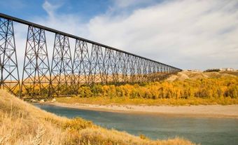
The headwaters of the Oldman River are at Mount Lyall on the border between British Columbia and Alberta. From there, the river flows southeast to the Rocky Mountain foothills and into the Oldman River Reservoir, along with the Crowsnest and Castle rivers. The river then flows east past the Oldman River Dam, and a portion of its summer flow is diverted into irrigation canals toward Keho, Picture Butte Lake and Park Lake reservoirs. It goes on through Fort Macleod and into the semi-arid Prairie region. Between Fort Macleod and Lethbridge the Oldman is joined by the Belly and St. Mary rivers, both of which originate in northwestern Montana, United States. The river continues east across the Prairies, is joined by the Little Bow River, then flows past Taber to the confluence with the Bow River and the beginning of the South Saskatchewan River.
Flora and Fauna
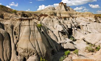
The Oldman River flows from the steep Rocky Mountain headwaters to the Prairie grasslands, much of which has been converted for agricultural use. The forested upper Oldmanbasin is characterized by alpine fir, Engelmann spruce and lodgepole pine and is home to black and grizzly bears, wolverines, mountain goat, deer,grouse, and waterfowl. Vegetation from the foothills to Prairies includes wheatgrass, fescue, quakingaspen, and mixed shrubs, while dominant vegetation along the river valley is cottonwoods and poplars. Wildlifein this area of the basin includes deer, coyote,rabbit, antelope, rattlesnakes, golden eagle and grouse. The cold water of the upper Oldman is home to mountain whitefish, trout and shorthead sculpin, while warmer downstream water is home to northern pike, walleye,goldeye and yellow perch. Additionally, river environments are home to beaver and muskrat.
Environmental Concerns

The population of the Oldman River Basin is relatively low, but water demand is high, with up to 70 per cent of the median streamflow being used by surrounding communities, primarily for irrigation.The Oldman River is regulated by the Oldman Dam, and an irrigation canal downstream of the dam diverts water to nearby reservoirs for use by local farms. Additionally, major irrigation infrastructure exists on several tributaries to the Oldman River.Water is also withdrawn for industrial uses and municipalities, including Fort Macleod and Lethbridge.
These water withdrawals reduce streamflow, and when combined with declining snowpack and earlier snowmelt (due largely to climate change) put a strain on the Oldman Riversystem. The implications of reduced flow include higher water temperatures, making it more difficult for cold-water aquatic species to live in the river. In addition, streamside vegetation is affected by drought-like conditions.
Water quality is good in upstream portions of the river but decreases downstream. It is at its worst during the growing season (May–August). Water quality is affected by agricultural, municipal and industrial runoff, which can include bacterial contaminants,fertilizers, and pesticides. Additionally, poor water quality from tributaries contributes to water quality issues on the Oldman River.
In June 2013, heavy rains and snowmelt in southern Alberta caused a devastating flood on the Bow and Oldman rivers. Several communities, including Lethbridge,declared a state of emergency. Additionally, the flood resulted in poor water quality including increased fecal bacteria.
History
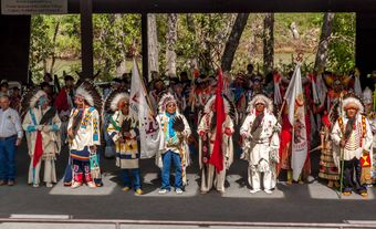
The Oldman River basin is the traditional territory of the Piikani Nation of the Blackfoot Confederacy. The Oldman River is named after Napi, the Old Man, who is the creatorof the Earth and all its living inhabitants. The Old Man’s Playing Ground, a place of great cultural significance where Piikani people gathered to play games, is located along the headwaters of the Oldman River. The Piikani were nomadic, gathering rootsand berries and, in the autumn, engaging in large-scale communal buffalo hunting. The hunt involved buffalo jumps, such as Head-Smashed-In Buffalo Jump,located just north of the river and to the west of Fort Macleod. Buffalo were a critical resource forthe sustenance of the Piikani people, and later as an economic resource during the fur trade. Several factors, including the introduction of rifles, drove buffalo populations to near extinction in the 1880s.
The first known European explorer to reach the Oldman River was Peter Fidler, a Hudson’s Bay Company surveyor, during the winter of 1792–93. Shortly following his exploration, the Hudson’s Bay Company sent fur traders to initiate trade with the Piikani. However, European settlement of the region didn’t occur until the 1870s, primarily fuelled by thewhiskey trade, with settlements such as Fort Whoop-Up. Following the arrival of the North West Mounted Police in 1874 — and the civil order that came with them — Europeans began settling on farms and ranches and diverting water from the Oldman River for irrigation.