Share on Facebook
 Share on X
 Share by Email
 Share on Google Classroom

Continental Divide of the Americas
In Canada, the main continental divide is known as the Continental Divide of the Americas, or Great Divide. It roughly follows the ridge of the Rocky Mountains. The water separated along the Great Divide eventually reaches one of the Arctic, Atlantic or Pacific Oceans (with the exception of certain “closed watersheds” in Saskatchewan and Alberta). Significant sections of the Alberta-British Columbia and Yukon-Northwest Territories borders follow this natural boundary, as does the Great Divide Trail.
The Canadian portion is only a fraction of the Continental Divide of the Americas. In its entirety, the Great Divide spans almost the whole length of North and South America, from Cape Prince of Wales in Alaska to the southern tip of South America, running atop the Rocky Mountains, the Sierra Madre Occidental range and the Andes.


While other continental divides exist in North America, scientists do not agree on the precise number. Important examples in Canada are the Arctic Divide, the Laurentian Divide and the St. Lawrence Divide.
Arctic Divide

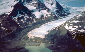
The Arctic Divide (sometimes called the Northern Divide) runs from Snow Dome mountain, on the edge of the Columbia Icefield in Jasper National Park, across Alberta, Saskatchewan and the Northwest Territories to finally reach Nunavut. Three drainage basins meet at Snow Dome, a phenomenon called a hydrological apex. This occurs because Snow Dome is at the junction of two continental divides: the Great Divide and the Arctic Divide. Precipitation that falls on Snow Dome mountain can end up in the Pacific (if it falls on the west side of the Great Divide), the Atlantic (if it falls on the east side of the Great Divide and the south of the Arctic Divide), or the Arctic Ocean (if it falls on the east side of the Great Divide and the north of the Arctic Divide).
Laurentian Divide

The Laurentian Divide spans most of the width of the continent, running from Montana to Labrador. Its path begins in the United States’ Rocky Mountains, continuing through southern Alberta and Saskatchewan before swinging back into the United States and reaching the southern tip of the Red River. Rivers south of this line are part of the Missouri-Mississippi River system. The divide then comes back up into Canada just northwest of the Great Lakes. At that point, any water draining south of the Laurentian Divide ends up in the Great Lakes–St. Lawrence River basin. Water draining to the north of that line flows toward Hudson Bay. The divide then cuts through Ontario and Québec and runs along the much-eroded Canadian Shield to reach the border between Québec and Labrador. Water flowing from this section of the divide was diverted into dammed reservoirs to generate hydroelectric power as part of the James Bay Project.
St. Lawrence Divide
The St. Lawrence Divide runs south of the Great Lakes in the United States before following the St. Lawrence River. Water travelling north of this line ends up in the Great Lakes–St. Lawrence basin. Water south of the line ends up in the Mississippi (and then the Gulf of Mexico) or the Atlantic basin. (See also Labrador Boundary Dispute, Oregon Treaty, Laurentian Highlands.)